File:Canadawineregions.png
Jump to navigation
Jump to search

Size of this preview: 685 × 599 pixels. Other resolutions: 274 × 240 pixels | 549 × 480 pixels | 878 × 768 pixels | 1,171 × 1,024 pixels | 1,388 × 1,214 pixels.
Original file (1,388 × 1,214 pixels, file size: 67 KB, MIME type: image/png)
Captions
Captions
Add a one-line explanation of what this file represents
Summary
[edit]
| Description |
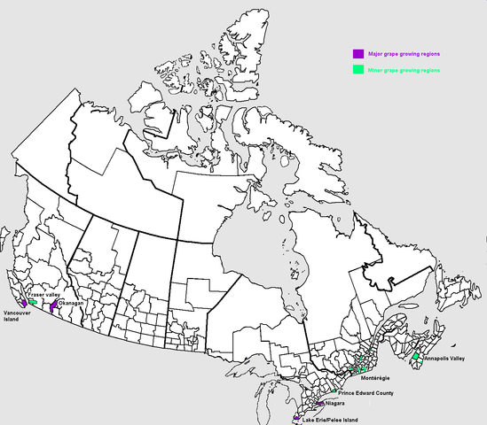
English: Map of grape growing regions in Canada. Own work based on Public Domain Census Subdivision map by Earl Andrew at File:Censusdivisions.PNG and information in John Schreiner (2005), The Wines of Canada, ISBN 1-84533-007-2 Français : Carte des régions viticoles du Canada. |
| Date | |
| Source | Own work |
| Author | Luigi Zanasi |
Licensing
[edit]
| I, the copyright holder of this work, release this work into the public domain. This applies worldwide. In some countries this may not be legally possible; if so: I grant anyone the right to use this work for any purpose, without any conditions, unless such conditions are required by law. |
File history
Click on a date/time to view the file as it appeared at that time.
| Date/Time | Thumbnail | Dimensions | User | Comment | |
|---|---|---|---|---|---|
| current | 16:26, 10 September 2006 | | 1,388 × 1,214 (67 KB) | Luigizanasi (talk | contribs) | |
| 16:19, 10 September 2006 |  | 1,388 × 1,214 (67 KB) | Luigizanasi (talk | contribs) | {{Information |Description=Map of grape growing regions in Canada/Carte des régions viticoles du Canada |Source=OWN Work Based on Public Domain Census Subdivision map by Earl Andrew at Image:Censusdivisions.PNG and information in John Schreiner (2005), ' |
You cannot overwrite this file.
File usage on Commons
The following page uses this file:
File usage on other wikis
The following other wikis use this file:
- Usage on cs.wikipedia.org
- Usage on de.wikipedia.org
- Usage on en.wikipedia.org
- Usage on hy.wikipedia.org
- Usage on nl.wikipedia.org
- Usage on nn.wikipedia.org
- Usage on ru.wikipedia.org
- Usage on sv.wikipedia.org
- Usage on uk.wikipedia.org