File:Canton1860.jpg
跳转到导航
跳转到搜索

本预览的尺寸:800 × 457像素。 其他分辨率:320 × 183像素 | 640 × 366像素 | 1,024 × 585像素 | 1,280 × 731像素 | 2,560 × 1,462像素 | 11,680 × 6,672像素。
原始文件 (11,680 × 6,672像素,文件大小:11.72 MB,MIME类型:image/jpeg)
说明
说明
添加一行文字以描述该文件所表现的内容
| 警告 | 部分浏览器在浏览此图片的完整大小时可能会遇到困难:该图片中有数量巨大的像素点,可能无法完全载入或者导致您的浏览器停止响应。 |
|---|
摘要[编辑]
| 描写 |
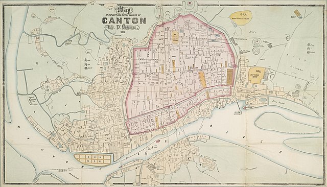
English: "Map of the City and Entire Suburbs of Canton in 1860 by Rev. D. Vrooman", an updating of Vrooman's 1855 map of the city, incorporating the destruction of the Thirteen Factories, the erection of Shamian, and minor adjustments to his prospective map of the city following its opening to foreign visitors following the treaties of Tianjin and Beijing.
中文(简体):广州市1860年地图,藏于澳洲国家图书馆。
中文(繁體):廣州市1860年地圖,藏於澳洲國家圖書館。 |
||||||||||||||||
| 日期 | |||||||||||||||||
| 来源 | http://www.nla.gov.au/apps/cdview/nla.map-lms636 | ||||||||||||||||
| 创作作者 |
|
||||||||||||||||
| Geotemporal data | |||||||||||||||||
| 边框 |
|
||||||||||||||||
| 地理参考 | |||||||||||||||||
| 其他版本 | |||||||||||||||||

许可协议[编辑]
|
本作品在其来源国以及其他著作权期限是作者逝世后100年或以下的国家和地区属于公有领域。 | |
| 本文件已被确认为免除已知的著作权法限制(包括所有相关权利)。 | |
文件历史
点击某个日期/时间查看对应时刻的文件。
| 日期/时间 | 缩略图 | 大小 | 用户 | 备注 | |
|---|---|---|---|---|---|
| 当前 | 2018年1月17日 (三) 14:25 | | 11,680 × 6,672(11.72 MB) | User-duck(留言 | 贡献) | Cropped using CropTool with lossless mode. |
| 2011年8月24日 (三) 10:34 |  | 11,952 × 7,536(13.97 MB) | Gzdavidwong(留言 | 贡献) | {{Information |Description ={{en|1=Maps of Canton City in 1860.}} {{zh-hans|1=广州市1860年地图。}} {{zh-hant|1=廣州市1860年地圖。}} |Source ={{own}} |Author =Gzdavidwong |Date =1860 |Permissi |
您不可以覆盖此文件。
文件用途
以下页面使用本文件:
全域文件用途
以下其他wiki使用此文件:
- en.wikipedia.org上的用途
- fr.wikipedia.org上的用途
- ha.wikipedia.org上的用途
- ja.wikipedia.org上的用途
- mai.wikipedia.org上的用途
- ru.wikipedia.org上的用途
- www.wikidata.org上的用途
- zh-yue.wikipedia.org上的用途
- zh.wikipedia.org上的用途