File:Cape Cod Landsat 7.jpg
Salta a la navegació
Salta a la cerca

Mida d'aquesta previsualització: 676 × 600 píxels. Altres resolucions: 271 × 240 píxels | 541 × 480 píxels | 866 × 768 píxels | 1.154 × 1.024 píxels | 2.418 × 2.145 píxels.
Fitxer original (2.418 × 2.145 píxels, mida del fitxer: 1,07 Mo, tipus MIME: image/jpeg)
Llegendes
Llegendes
Afegeix una explicació d'una línia del que representa aquest fitxer
| Descripció |
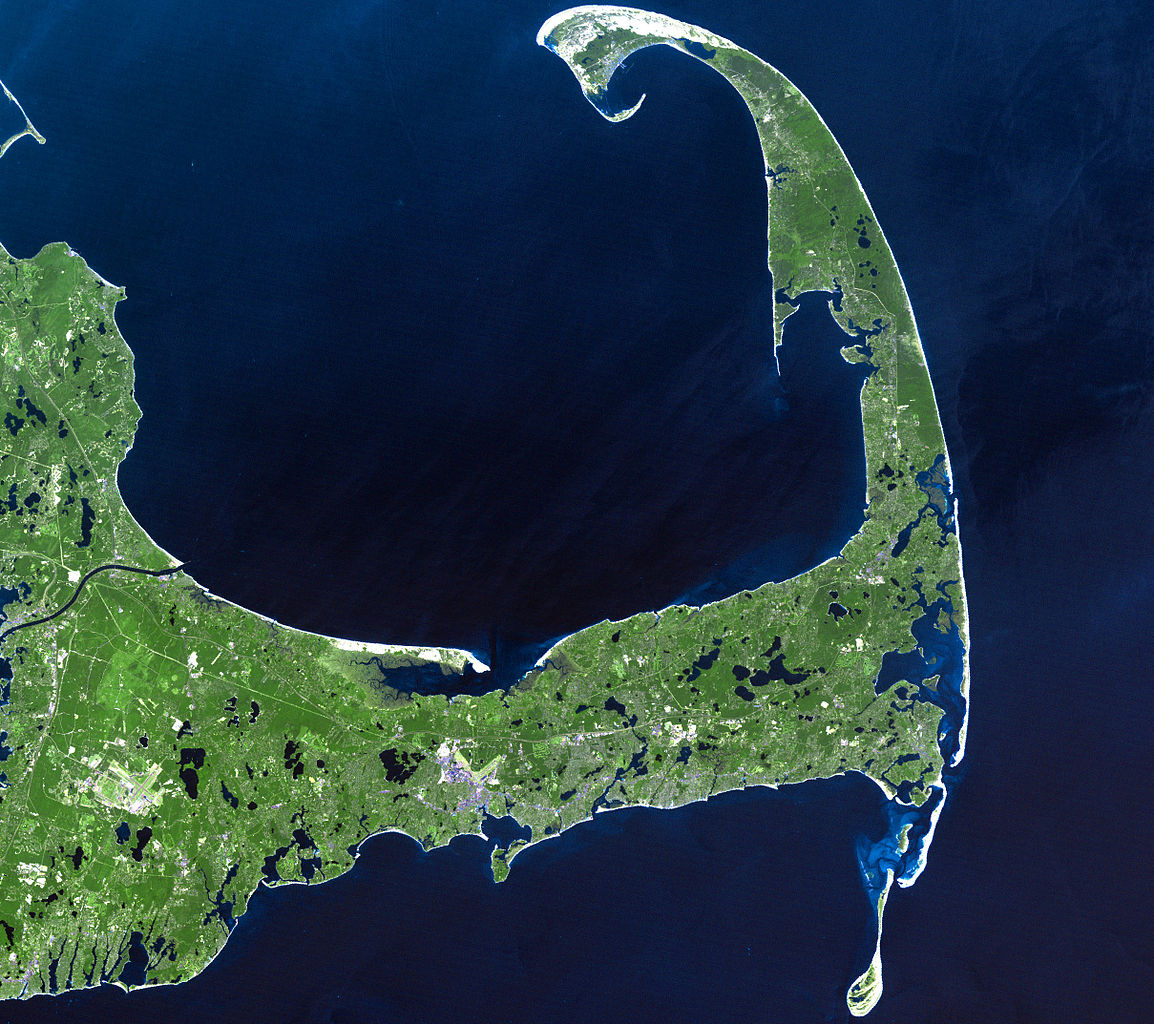
English: In easternmost Massachusetts, Cape Cod juts dramatically out into the Atlantic Ocean. The 65-mile peninsula has Cape Cod Bay to its north, the Nantucket Sound to its south and the Atlantic Ocean to its east. It is the world’s largest glacially formed peninsula; a remnant landscape left by the retreating Laurentide Ice Sheet.
The outer shore of the cape, from Long Point to south of Pleasant Bay, was designated as the Cape Cod National Seashore in August of 1961. The National Seashore encompasses over 44,000 acres of land, which includes marine, estuarine, and freshwater ecosystems. This Landsat 7 image was acquired on June 22, 2002. The pseudo-natural colour image, is a composite of ETM+ bands 7, 5, and 3. Cape Cod is found on Landsat WRS-2 Path 11 Row 31. |
| Data |
22 de juny de 2002 |
| Font |
http://landsat.gsfc.nasa.gov/images/lg_jpg/f0006_06.22.02.jpg (http://landsat.gsfc.nasa.gov/images/archive/f0006.html) |
| Autor |
NASA/Landsat 7. Original uploader was Ktr101 at en.wikipedia |
Llicència[modifica]
| Aquest fitxer és en el domini públic perquè ha estat creat per la NASA. L'avís legal de la NASA diu que «el material de la NASA no està protegit per copyright si no es diu el contrari». (NASA copyright policy page o JPL Image Use Policy). | ||
 |
Atenció:
|
Aquesta imatge és de domini públic, ja que conté materials que originalment van venir del Servei Geològic dels Estats Units d'Amèrica, una agència del Departament de l'Interior dels Estats Units. Per a obtenir més informació, consulti la política oficial de drets de l'USGS.
|
Registre original de càrregues[modifica]
La pàgina de descripció original era aquí. Els noms d'usuari a continuació es refereixen a en.wikipedia.
- 2008-06-14 02:08 Ktr101 2418×2145× (1120814 bytes) Cape Cod from a Landsat 7 image in 2002. Source:http://landsat.gsfc.nasa.gov/images/archive/f0006.html
Historial del fitxer
Cliqueu una data/hora per veure el fitxer tal com era aleshores.
| Data/hora | Miniatura | Dimensions | Usuari/a | Comentari | |
|---|---|---|---|---|---|
| actual | 16:13, 9 ago 2009 | | 2.418 × 2.145 (1,07 Mo) | Transatracurium (discussió | contribucions) | {{Information |Description={{en| In easternmost Massachusetts, Cape Cod juts dramatically out into the Atlantic Ocean. The 65-mile peninsula has Cape Cod Bay to its north, the Nantucket Sound to its south and the Atlantic Ocean to its east. It is the worl |
No podeu sobreescriure aquest fitxer.
Ús del fitxer
La pàgina següent utilitza aquest fitxer:
Ús global del fitxer
Utilització d'aquest fitxer en altres wikis:
- Utilització a ca.wikipedia.org
- Utilització a de.wikipedia.org
- Utilització a en.wikipedia.org
- Cape Cod
- User:Dchurbuck
- User:Cape cod naturalist
- User:Clariosophic
- User:Seduisant
- User:Quissett
- Attack on Orleans
- User:Lrsears
- Wikipedia:WikiProject Cape Cod and the Islands
- Template:User WikiProject Cape Cod and the Islands
- User:Ktr101/Userboxes
- User:Grolltech
- User:Happyandrew1994
- Wikipedia:Userboxes/WikiProjects/Regional/03
- Shields (album)
- Wikipedia:Userboxes/WikiProjects/alphabetical/06
- Category:Wikipedians interested in Cape Cod and the Islands
- User:M V D H P
- Utilització a he.wikipedia.org
- Utilització a mk.wikipedia.org
- Utilització a sk.wikipedia.org
- Utilització a sr.wikipedia.org
- Utilització a www.wikidata.org