File:Captaincy General of Chile (orthographic projection).svg
Μετάβαση στην πλοήγηση
Πήδηση στην αναζήτηση

Το μέγεθος αυτής της PNG προεπισκόπησης αυτού του SVG το αρχείο: 550 × 550 εικονοστοιχεία. Άλλες αναλύσεις: 240 × 240 εικονοστοιχεία | 480 × 480 εικονοστοιχεία | 768 × 768 εικονοστοιχεία | 1.024 × 1.024 εικονοστοιχεία | 2.048 × 2.048 εικονοστοιχεία.
Πρωτότυπο αρχείο (Αρχείο SVG, ονομαστικό μέγεθος 550 × 550 εικονοστοιχεία, μέγεθος αρχείου: 844 KB)
Λεζάντες
Λεζάντες
Δεν ορίστηκε λεζάντα
Σύνοψη
[επεξεργασία]| Περιγραφή |
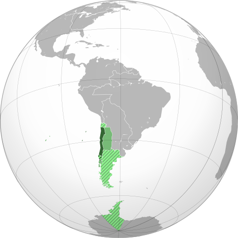
English: Approximate extension of the Captaincy General of Chile in orthographic projection.
Territory under effective control of the Captaincy by 1786.
Territory of the Captaincy, ceded or transferred before 1786.
Claimed, disputed, not under effective control or only nominal control territory associated to the Captaincy by 1786.
Claimed, disputed, not under effective control or only nominal control territory associated with ceded territories of the Captaincy. Español: Ubicación geográfica aproximada de la Capitanía General de Chile en proyección ortográfica.
Territorio efectivo de la Capitanía hacia 1786.
Territorio de la Capitanía, cedido o transferido a otras entidades previo a 1786.
Territorio reclamado, disputado, sin control efectivo o sólo control nominal asociado a la Capitanía hacia 1786.
Territorio reclamado, disputado, sin control efectivo o sólo control nominal asociado a territorios cedidos por la Capitanía. |
||
| Ημερομηνία | |||
| Πηγή |
Own work based on: the Brazil (orthographic projection).svg, created by the Wikimedia Commons user Ssolbergj, under a Creative Commons Licence. Boundaries based in the following sources:
|
||
| Δημιουργός | B1mbo | ||
| Άδεια (Επαναχρησιμοποίηση αυτού του αρχείου) |
Εγώ, ο κάτοχος των πνευματικών δικαιωμάτων αυτού του έργου, το δημοσιεύω δια του παρόντος υπό την εξής άδεια χρήσης: Το αρχείο διανέμεται υπό την άδεια Creative Commons Αναφορά προέλευσης 3.0 Μη εισαγόμενη
|
||
| άλλες εκδόσεις |
.svg)
|
||
| SVG ανάπτυξη |
.svg)
.svg)
.svg)
.svg)
.svg)
.svg)
.svg)
.svg)
.svg)
.svg)
.svg)
.svg)
.svg)
.svg)
.svg)
.svg)
.svg)
.svg)
.svg)
.svg)
.svg)
.svg)
.svg)
.svg)
.svg)
.svg)
.svg)
.svg)
.svg)
.svg)
.svg)
.svg)
.svg)
.svg)
.svg)
.svg)
.svg)
.svg)
.svg)
.svg)
.svg)
.svg)
.svg)
.svg)
.svg)
.svg)
.svg)
.svg)
.svg)
.svg)
.svg)
.svg)
.svg)
.svg)
.svg)
.svg)
.svg)
.svg)
.svg)
.svg)
.svg)
.svg)
.svg)
.svg)
.svg)
.svg)
.svg)
.svg)
.svg)
.svg)
.svg)
.svg)
.svg)

.svg)

.svg)

.svg)
.svg)
.svg)
.svg)
.svg)
.svg)
.svg)


.svg)
.svg)
.svg)
.svg)
.svg)
.svg)
.svg)

.svg)
.svg)
.svg)
.svg)
.svg)
.svg)
.svg)
.svg)
.svg)
.svg)

.svg)
.svg)
.svg)
.svg)
.svg)
.svg)
.svg)
_without_national_boundaries.svg)
.svg)
.svg)
.svg)
.svg)
.svg)
.svg)

.svg)
.svg)
.png)
.svg)
.svg)
.svg)
.svg)

.svg)
.svg)
.svg)
.svg)
.svg)
.svg)
.svg)
.svg)
.svg)
.svg)
.svg)

.svg)
.svg)
.svg)
.svg)
.svg)
.svg)
.svg)
.svg)
.svg)

.svg)
.svg)

.svg)
.svg)
.svg)
.svg)
.svg)
.svg)
.svg)
.svg)
.svg)
.svg)
.svg)
.svg)
.svg)
.svg)
.svg)
.svg)
.svg)
.svg)
.svg)
.svg)
.svg)
.svg)
.svg)
.svg)
.svg)
.svg)
.svg)
_-_Crimea_disputed.svg)
.svg)
.svg)
.svg)
.svg)
.svg)
.svg)
.svg)
.svg)
.svg)
.svg)
.svg)
_political.svg)
.svg)
.svg)
.svg)
.svg)
_-_Crimea_disputed_-_no_borders.svg)
.svg)
.svg)
.svg)
.svg)
.svg)
.svg)
.svg)
.svg)
.svg)
.svg)
.svg)

.svg)
.svg)
.svg)

.png)
.svg)
.svg)
.svg)
.svg)
.svg)
.svg)
.svg)
.svg)
.svg)
.svg)
.svg)
.svg)
.svg)
.svg)
.svg)
.svg)
.svg)
.svg)
.svg)
.svg)
.svg)
.svg)
.svg)
.svg)
.svg)
.svg)
.svg)
.svg)
.svg)
.svg)
.svg)
.svg)
.svg)
.svg)
.png)
.svg)
.svg)
.svg)
_(orthographic_projection).png)

.svg&action=edit§ion=1)
.svg)
.jpg)
.svg)
Ιστορικό αρχείου
Πατήστε σε μια ημερομηνία/ώρα για να δείτε το αρχείο όπως εμφανιζόταν εκείνη την χρονική στιγμή.
| Ημερομηνία/Ώρα | Μικρογραφία | Διαστάσεις | Χρήστης | Σχόλιο | |
|---|---|---|---|---|---|
| τρέχον | 19:36, 7 Νοεμβρίου 2022 | | 550 × 550 (844 KB) | Janitoalevic (συζήτηση | Συνεισφορά) | Borders bases on the Map of Cano y Olmedilla of 1775 |
| 16:54, 18 Οκτωβρίου 2022 |  | 550 × 550 (373 KB) | Janitoalevic (συζήτηση | Συνεισφορά) | Added Terra Australis (1555) and Easter Island (1770) | |
| 22:37, 7 Ιουλίου 2022 |  | 550 × 550 (364 KB) | Janitoalevic (συζήτηση | Συνεισφορά) | límite en el río Loa entre la prov. de Santiago y Arequipa (Eyzaguirre, Jaime, 1967) | |
| 22:11, 19 Σεπτεμβρίου 2019 |  | 550 × 550 (253 KB) | B1mbo (συζήτηση | Συνεισφορά) | Correcciones | |
| 17:00, 10 Ιουλίου 2012 |  | 550 × 550 (139 KB) | Jespinos (συζήτηση | Συνεισφορά) | Reverted to version as of 16:58, 10 July 2012 | |
| 16:58, 10 Ιουλίου 2012 |  | 550 × 550 (150 KB) | Jespinos (συζήτηση | Συνεισφορά) | Reverted to version as of 09:07, 26 May 2012 | |
| 16:58, 10 Ιουλίου 2012 |  | 550 × 550 (139 KB) | Jespinos (συζήτηση | Συνεισφορά) | Reverted to version as of 23:27, 20 June 2010 | |
| 09:07, 26 Μαΐου 2012 |  | 550 × 550 (150 KB) | Franco-eisenhower (συζήτηση | Συνεισφορά) | Límite verdadero Patagonia: http://www.scielo.cl/scielo.php?pid=S0717-71942002003500009&script=sci_arttext&tlng=es | |
| 23:27, 20 Ιουνίου 2010 |  | 550 × 550 (139 KB) | B1mbo (συζήτηση | Συνεισφορά) | == Summary == {{created with Inkscape}} {{Information |Description= {{en|Location of the Captaincy General of Chile in orthographic projection, approx. 1796. {{legend|DarkGreen|Sovereign territory.}} {{legend|Lime|Terr |
Δεν μπορείτε να αντικαταστήσετε αυτό το αρχείο.
Χρήση αρχείου
Περισσότεροι από 100 σελίδες χρησιμοποιούν αυτό το αρχείο. Η ακόλουθη λίστα δείχνει τις πρώτες 100 σελίδες που συνδέονται με αυτό το αρχείο μονοσήμαντα. Η πλήρης λίστα είναι διαθέσιμη.
.svg)
- Grey–green orthographic projections maps
- User:Heraldry/Projections
- User:Ssolbergj/orthographic
- File:ALBA (orthographic projection).png
- File:Africa (orthographic projection).svg
- File:African Union (orthographic projection).svg
- File:Almoravid map.svg
- File:America do Sul (orthographic projection).jpg
- File:Americas (orthographic projection).svg
- File:Andean Community (orthographic projection).svg
- File:Antarctica (orthographic projection).svg
- File:Antillas (orthographic projection).svg
- File:Arctic (orthographic projection).svg
- File:Argentina (orthographic projection).png
- File:Argentina (orthographic projection).svg
- File:Aridoamerica (orthographic projection).svg
- File:Armenia (orthographic projection).svg
- File:Asia (orthographic projection).svg
- File:Association of Southeast Asian Nations (orthographic projection).svg
- File:Australia-New Guinea (orthographic projection).svg
- File:Australia (orthographic projection).svg
- File:Australia map with outlying islands.svg
- File:Bhutan (orthographic projection).svg
- File:Brazil (orthographic projection).svg
- File:CECAFA-Map.svg
- File:Canada (orthographic projection).svg
- File:Cape Verde (orthographic projection).svg
- File:Captaincy General of Chile (orthographic projection).svg
- File:Central America (orthographic projection).svg
- File:Central Asia (orthographic projection).svg
- File:Chile (orthographic projection).svg
- File:Colombia (orthographic projection).svg
- File:Democratic Republic of the Congo (orthographic projection).svg
- File:Dominion of Pakistan & Indian Controlled Kashmir (orthographic projection).svg
- File:East Asia (orthographic projection).svg
- File:Ecuador (orthographic projection).svg
- File:Europe (orthographic projection).svg
- File:European Union (orthographic projection).svg
- File:Federal Republic of Central America (orthographic projection).svg
- File:First Brazilian Empire (orthographic projection).svg
- File:First Mexican Empire (orthographic projection).svg
- File:Georgia (orthographic projection).svg
- File:Germany (orthographic projection).svg
- File:Global European Union.svg
- File:Great Colombia (orthographic projection).svg
- File:Greater Middle East (orthographic projection).svg
- File:Haiti (orthographic projection).svg
- File:India (orthographic projection).svg
- File:Indonesia (orthographic projection).svg
- File:Iran (orthographic projection).svg
- File:Iraq (orthographic projection).svg
- File:Jamaica (orthographic projection).svg
- File:Japan (orthographic projection).svg
- File:Kazakhstan (orthographic projection).svg
- File:Latin America (orthographic projection).svg
- File:Lusophone America (orthographic projection).svg
- File:MERCOSUR (orthographic projection).svg
- File:Madagascar (orthographic projection).svg
- File:Maghreb (orthographic projection).svg
- File:Malaysia (orthographic projection).svg
- File:Mayan languages (orthographic projection).svg
- File:Mesoamerica (orthographic projection) with borders.svg
- File:Mexico (orthographic projection).svg
- File:Mexico and Central America (orthographic projection).svg
- File:Middle East (orthographic projection).svg
- File:Mongolia (orthographic projection).svg
- File:New Spain (orthographic projection).svg
- File:New Zealand (orthographic projection).svg
- File:Nigeria (orthographic projection).svg
- File:North Africa (orthographic projection).svg
- File:North America (orthographic projection).svg
- File:North American Agreement (orthographic projection).svg
- File:North Korea (orthographic projection).svg
- File:Papua New Guinea (orthographic projection).svg
- File:Paraguay (orthographic projection).svg
- File:People's Republic of China (orthographic projection).svg
- File:Peru (orthographic projection).svg
- File:Peru–Bolivia Confederation (orthographic projection).svg
- File:Philippines (orthographic projection).svg
- File:Republic of Artsakh (orthographic projection).svg
- File:Republic of China (orthographic projection).svg
- File:Rio Group (orthographic projection).svg
- File:Roman Empire (orthographic projection).svg
- File:Russian Federation (orthographic projection).svg
- File:Second Mexican Empire (orthographic projection).svg
- File:South Asia (orthographic projection) without national boundaries.svg
- File:South Korea (orthographic projection).svg
- File:Southern Europe (orthographic projection).svg
- File:Tawantinsuyu (orthographic projection).svg
- File:The Philippines and ASEAN (orthographic projection).svg
- File:Third Reich (orthographic projection).svg
- File:Tunisia (orthographic projection).svg
- File:Turkey (orthographic projection).svg
- File:Union of South American Nations (orthographic projection).svg
- File:Union of Soviet Socialist Republics (orthographic projection).svg
- File:United Provinces of Central America (orthographic projection).svg
- File:Venezuela (orthographic projection).svg
- File:Viceroyalty of Peru (orthographic projection).svg
- File:Viceroyalty of the Río de la Plata (orthographic projection).svg
- File:Wilsonian Armenia (orthographic projection).svg
.png)
.svg)
.jpg)
.svg)
.svg)
.png)
.svg)
.svg)
.svg)
.svg)
.svg)
.svg)
.svg)
_with_borders.svg)
.svg)
.svg)
.svg)
.svg)
.svg)
.svg)
Δείτε περισσότερους συνδέσμους προς αυτό το αρχείο.
Καθολική χρήση αρχείου
Τα ακόλουθα άλλα wiki χρησιμοποιούν αυτό το αρχείο:
- Χρήση σε ar.wikipedia.org
- Χρήση σε ca.wikipedia.org
- Χρήση σε cs.wikipedia.org
- Χρήση σε en.wikipedia.org
- Χρήση σε es.wikipedia.org
- Χρήση σε eu.wikipedia.org
- Χρήση σε fr.wikipedia.org
- Χρήση σε he.wikipedia.org
- Χρήση σε it.wikipedia.org
- Χρήση σε lt.wikipedia.org
- Χρήση σε pt.wikipedia.org
- Χρήση σε ru.wikipedia.org
- Χρήση σε sv.wikipedia.org
- Χρήση σε th.wikipedia.org
- Χρήση σε uk.wikipedia.org
- Χρήση σε www.wikidata.org
- Χρήση σε zh.wikipedia.org
.svg&oldid=877984581)