File:Carnegiea gigantea range map.jpg
Naviqasiyaya keç
Axtarışa keç

Sınaq göstərişi ölçüsü: 364 × 599 piksel. Digər ölçülər: 146 × 240 piksel | 464 × 763 piksel.
Faylın orijinalı (464 × 763 piksel, fayl həcmi: 65 KB, MIME növü: image/jpeg)
Captions
Captions
Add a one-line explanation of what this file represents

|
This biogeographical map image could be re-created using vector graphics as an SVG file. This has several advantages; see Commons:Media for cleanup for more information. If an SVG form of this image is available, please upload it and afterwards replace this template with
{{vector version available|new image name}}.
It is recommended to name the SVG file “Carnegiea gigantea range map.svg”—then the template Vector version available (or Vva) does not need the new image name parameter. |


Xülasə[redaktə]
| İzah |
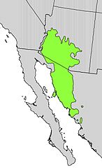
English: Range map of Cereus giganteus (Synonym for Carnegiea gigantea) |
| Tarix | |
| Mənbə | Digital representation of "Atlas of United States Trees" by Elbert L. Little, Jr. [1] |
| Müəllif | U.S. Geological Survey |
Lisenziya[redaktə]
This image is in the public domain in the United States because it only contains materials that originally came from the United States Geological Survey, an agency of the United States Department of the Interior. For more information, see the official USGS copyright policy.
|
Orijinal yükləmə gündəliyi[redaktə]
Transferred from en.wikipedia to Commons by Pinethicket using CommonsHelper.
The original description page was here. All following user names refer to en.wikipedia.
- 2012-10-05 23:16 Pinethicket 464×763× (66340 bytes) {{Information |Description=Range map of ''Cereus giganteus'' (Synonym for ''Carnegiea gigantea'') |Source=Digital representation of "Atlas of United States Trees" by Elbert L. Little, Jr. [http://esp.cr.usgs.gov/data/atlas/little/] |Date=...
Faylın tarixçəsi
Faylın əvvəlki versiyasını görmək üçün gün/tarix bölməsindəki tarixlərə klikləyin.
| Tarix/Vaxt | Kiçik şəkil | Ölçülər | İstifadəçi | Şərh | |
|---|---|---|---|---|---|
| indiki | 14:48, 13 oktyabr 2012 | | 464 × 763 (65 KB) | File Upload Bot (Magnus Manske) (müzakirə | töhfələr) | Transfered from en.wikipedia by User:Pinethicket using CommonsHelper |
Siz bu faylı yenidən yükləyə bilməzsiniz.
Fayl keçidləri
Aşağıdakı 3 səhifə bu faylı istifadə edir:
Faylın qlobal istifadəsi
Bu fayl aşağıdakı vikilərdə istifadə olunur:
- ar.wikipedia.org layihəsində istifadəsi
- arz.wikipedia.org layihəsində istifadəsi
- ast.wikipedia.org layihəsində istifadəsi
- bg.wikipedia.org layihəsində istifadəsi
- ca.wikipedia.org layihəsində istifadəsi
- ckb.wikipedia.org layihəsində istifadəsi
- cs.wikipedia.org layihəsində istifadəsi
- eo.wikipedia.org layihəsində istifadəsi
- eu.wikipedia.org layihəsində istifadəsi
- fa.wikipedia.org layihəsində istifadəsi
- hu.wikipedia.org layihəsində istifadəsi
- nl.wikipedia.org layihəsində istifadəsi
- nn.wikipedia.org layihəsində istifadəsi
- pt.wikipedia.org layihəsində istifadəsi
- ru.wikipedia.org layihəsində istifadəsi
- sv.wikipedia.org layihəsində istifadəsi
- th.wikipedia.org layihəsində istifadəsi
- www.wikidata.org layihəsində istifadəsi