File:Cart Bourgogne 1830.jpg

Original file (1,100 × 826 pixels, file size: 551 KB, MIME type: image/jpeg)
Captions
Captions
Summary
[edit]
| Description |
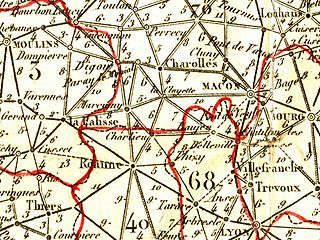
English: Map of Burgundy (Charolais - Brionnais) - France
Français : Carte de Bourgogne (Charolais - Brionnais)- France
Cette carte est extraite du "tableau de la France en 86 départements" réalisé vers 1830 dont l'auteur n'est pas connu. On y distingue les villes de Roanne, Charlieu, Marcygny (désormais Marcigny), La Clayette, Digoin, Paray le Monial, Charolles. A l'époque la France ne comptait que 86 départements : Nice et les deux Savoie ne furent françaises qu'en 1860 ; le territoire de Belfort a été institué suite à la guerre de 1870 - 1871. Ainsi sur cette carte ancienne, le département du Rhône porte le numéro 68 au lieu de 69, la Loire le 40 à la place de 42 et la Saône et Loire le 70 et non pas le 71. Les distances sont indiquées en milliers de toises (2 000 mètres). |
| Date | circa 1830 |
| Source | |
| Author | Tableau de la France en 86 départements (auteur anonyme) |
Licensing
[edit]
This image is in the public domain because it is a mere mechanical scan or photocopy of a public domain original, or – from the available evidence – is so similar to such a scan or photocopy that no copyright protection can be expected to arise. The original itself is in the public domain for the following reason:
This tag is designed for use where there may be a need to assert that any enhancements (eg brightness, contrast, colour-matching, sharpening) are in themselves insufficiently creative to generate a new copyright. It can be used where it is unknown whether any enhancements have been made, as well as when the enhancements are clear but insufficient. For known raw unenhanced scans you can use an appropriate {{PD-old}} tag instead. For usage, see Commons:When to use the PD-scan tag.  | ||||
File history
Click on a date/time to view the file as it appeared at that time.
| Date/Time | Thumbnail | Dimensions | User | Comment | |
|---|---|---|---|---|---|
| current | 12:23, 12 July 2008 | | 1,100 × 826 (551 KB) | Dlebouc (talk | contribs) | {{Information |Description={{en|1=Map of Burgundy (Charolais - Brionnais) - France}} {{fr|1=Carte de Bourgogne (Charolais - Brionnais)- France Cette carte est extraite du "tableau de la France en 86 départements" réalisé vers 1830 dont l'auteur n'est p |
You cannot overwrite this file.
File usage on Commons
The following page uses this file:
File usage on other wikis
The following other wikis use this file:
- Usage on fr.wikipedia.org
- Usage on oc.wikipedia.org