File:Carta Marina (sea serpent).jpeg
Jump to navigation
Jump to search

No higher resolution available.
Carta_Marina_(sea_serpent).jpeg (425 × 375 pixels, file size: 48 KB, MIME type: image/jpeg)
Captions
Captions
Add a one-line explanation of what this file represents
Summary[edit]
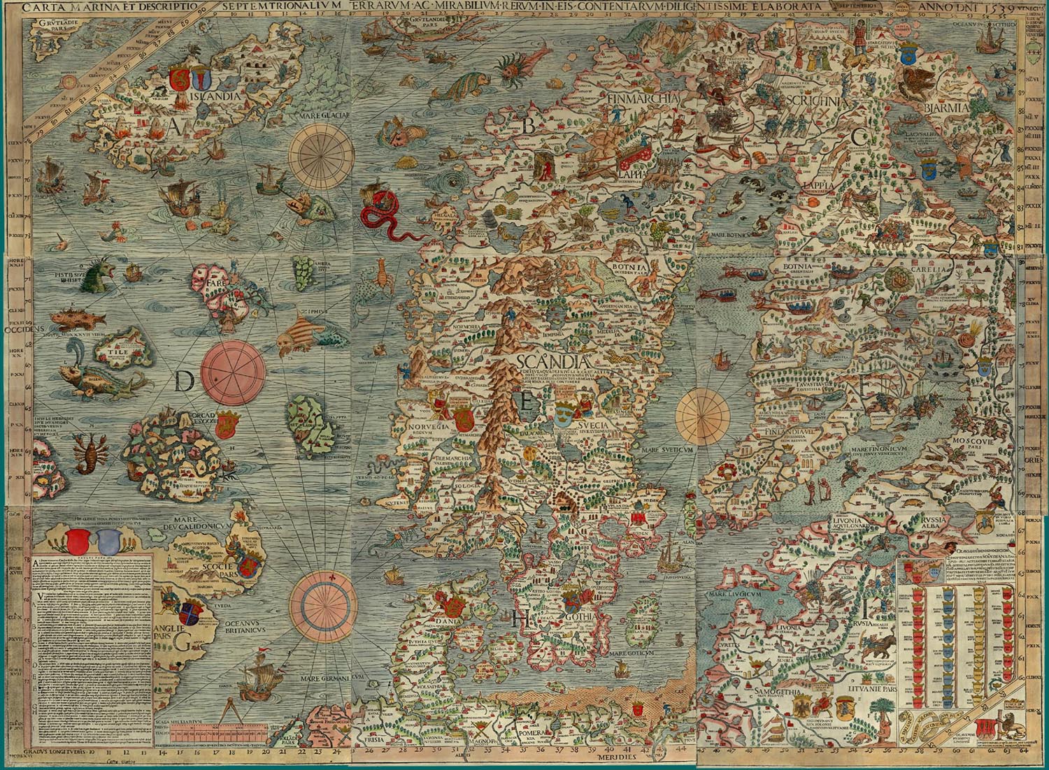
| Title |
Carta marina et descriptio septemtrionalium terrarum ac mirabilium rerum in eis contentarum diligentissime elaborata anno dni 1539 |
|||||||||||||||||||
| Description |
Deutsch: Carta marina, eine Landkarte Nordeuropas. Die Überschrift lautet: Seekarte und Beschreibung der nördlichen Lande und der dort vorkommenden wunderlichen Dinge, höchst sorgfältig gezeichnet in Venedig im Jahre 1539 mit großzügiger Unterstützung des Patriarchen von Venedig, des höchst ehrenwerten Herrn Geronimo Querini.
English: Carta marina, a wallmap of w:Scandinavia. The caption reads : Marine map and Description of the Northern Lands and of their Marvels, most carefully drawn up at Venice in the year 1539 through the generous assistance of the Most Honourable Lord Hieronymo Quirino.
Español: La Carta Marina es un mapa de Escandinavia de gran tamaño hecho. La leyenda dice: «Un mapa marino y descripción de las tierras nórdicas y de sus maravillas, dibujado cuidadosamente en Venecia en el año 1539 con la generosa ayuda del honorabilísimo Señor Hieronymo Quirino».
Français : La Carta Marina (Carte marine), une grande carte de la Scandinavie. La legende de la carte precise : « carte marine et la description des terres septentrionales, de leurs merveilles, tracee avec diligence a Venise en l'an 1539 avec l'assistance genereuse du tres honorable seigneur Hieronimus Quirino ».
Latina: Carta marina et Descriptio septemtrionalium terrarum ac mirabilium rerum in eis contentarum, diligentissime elaborata Anno Domini 1539 Veneciis liberalitate Reverendissimi Domini Ieronimi Quirini.
Português: Carta marina uma mapa de grandes dimensões da Escandinávia. A legenda indica: Um mapa marinho e descrição das terras nórdicas e suas maravilhas, desenhado cuidadosamente em Veneza no ano de 1539 com a generosa ajuda do mui honorável Lord Hieronymo Quirino.
Suomi: Carta Marina, Pohjoismaiden kartta. Kartan otsikon suomennos: Merikartta ja kuvaus pohjoisista maista sekä niissä olevista ihmeellisistä asioista, mitä suurimmalla huolellisuudella valmistettu Herran vuonna 1539.
E: Rosmarus est bellua marina, ad magnitudinem Elephantis. Littorum montes scandit et gramine pascitur. Somni gracia dentibus se a rup suspendit, et adeo profundet dormit, ut piscatores laqueis et funibus victum comprehendant [1] |
|||||||||||||||||||
| Date | ||||||||||||||||||||
| Source | http://www.npm.ac.uk/rsdas/projects/carta_marina/carta_marina_small.jpg | |||||||||||||||||||
| Creator |
|
|||||||||||||||||||
| Permission (Reusing this file) |
|
|||||||||||||||||||
| Georeferencing | If inappropriate please set warp_status = skip to hide. | |||||||||||||||||||
| Archival data | ||||||||||||||||||||
| artwork-references | https://rsg.pml.ac.uk/papers/rossby_carta_2003/rossby_carta_2003.pdf | |||||||||||||||||||
| Other versions |
Derivative versions
|
|||||||||||||||||||


.jpg)
.jpeg&action=edit§ion=1)
Info[edit]
.jpeg&action=edit§ion=3)
- This image is in 72 DPI.
- Some info: Figure 1. The 1539 Carta Marina by Olaus Magnus. Please credit the James Ford Bell Library, University of Minnesota if you reproduce this map. There is also a high-resolution version (5 MB) for printing. Direct link to there: http://bell.lib.umn.edu/map/OLAUS/indexo.html or http://purl.umn.edu/94326
 |
This picture made selected picture on Portal:Denmark, at EnWiki, in week 21, 2007 (view) |
|
This picture made selected picture on Portal:Denmark, at EnWiki, in week 22, 2007 (view) |
File history
Click on a date/time to view the file as it appeared at that time.
| Date/Time | Thumbnail | Dimensions | User | Comment | |
|---|---|---|---|---|---|
| current | 19:33, 23 January 2024 | | 425 × 375 (48 KB) | Blockhaj (talk | contribs) | File:Carta Marina.jpeg cropped 92 % horizontally, 90 % vertically using CropTool with precise mode. |
You cannot overwrite this file.
File usage on Commons
The following 2 pages use this file:
File usage on other wikis
The following other wikis use this file:
- Usage on sv.wikipedia.org
.jpeg&oldid=849154905)