File:Carte Chambéry Quartiers.png
Jump to navigation
Jump to search

Size of this preview: 450 × 600 pixels. Other resolutions: 180 × 240 pixels | 505 × 673 pixels.
Original file (505 × 673 pixels, file size: 426 KB, MIME type: image/png)
Captions
Captions
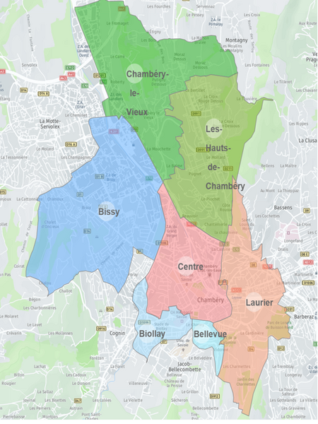
Map of the districts of the City of Chambéry
Summary[edit]
| Description |
Français : Carte des six quartiers qui composent la Ville de Chambéry
English: Map of the six districts that form the City of Chambéry |
| Date | |
| Source | Charte des conseils de quartier de la Ville de Chambéry |
| Author | Ville de Chambéry |
Licensing[edit]
This file is licensed under the Creative Commons Attribution-Share Alike 4.0 International license.
- You are free:
- to share – to copy, distribute and transmit the work
- to remix – to adapt the work
- Under the following conditions:
- attribution – You must give appropriate credit, provide a link to the license, and indicate if changes were made. You may do so in any reasonable manner, but not in any way that suggests the licensor endorses you or your use.
- share alike – If you remix, transform, or build upon the material, you must distribute your contributions under the same or compatible license as the original.
File history
Click on a date/time to view the file as it appeared at that time.
| Date/Time | Thumbnail | Dimensions | User | Comment | |
|---|---|---|---|---|---|
| current | 09:10, 3 July 2023 | | 505 × 673 (426 KB) | AodrenMg (talk | contribs) | Uploaded a work by Ville de Chambéry from Charte des conseils de quartier de la Ville de Chambéry with UploadWizard |
You cannot overwrite this file.
File usage on Commons
There are no pages that use this file.
File usage on other wikis
The following other wikis use this file:
- Usage on fr.wikipedia.org