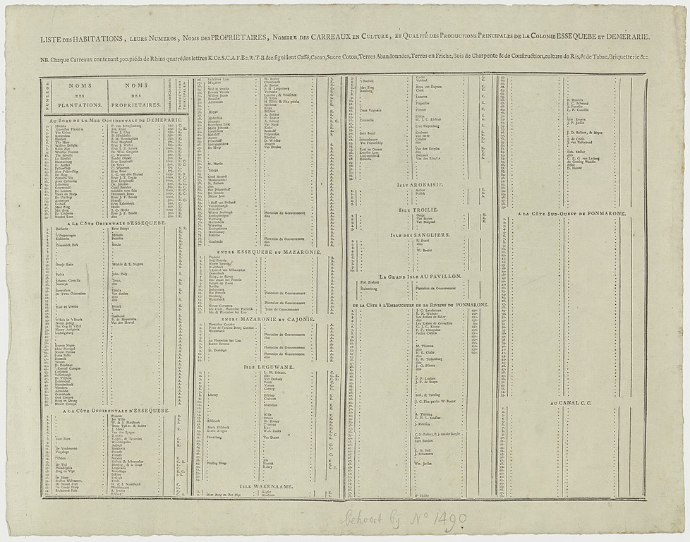
File:Carte Generale et Particuliere de la Colonie d'Essequebe et Demerary, située dans la Guiane en Amerique etc. (4.VEL 1490B).jpg
Jump to navigation
Jump to search

Size of this preview: 763 × 599 pixels. Other resolutions: 306 × 240 pixels | 611 × 480 pixels | 978 × 768 pixels | 1,280 × 1,005 pixels | 2,560 × 2,011 pixels | 6,760 × 5,310 pixels.
Original file (6,760 × 5,310 pixels, file size: 6.04 MB, MIME type: image/jpeg)
Captions
Captions
Add a one-line explanation of what this file represents
Summary
[edit]| Title |
Nederlands: Carte Generale et Particuliere de la Colonie d'Essequebe et Demerary, située dans la Guiane en Amerique etc. |
|||||||||||||||||||||||
| Date | ||||||||||||||||||||||||
| Source | Nationaal Archief | |||||||||||||||||||||||
| Creator |
Bouchenroeder, F. van (landmeter / kaartenmaker), Turpin, J. (graveur / etser), Brave, Wouter (uitgever) |
|||||||||||||||||||||||
| Geotemporal data | ||||||||||||||||||||||||
| Map location | Essequebo | |||||||||||||||||||||||
| Georeferencing | If inappropriate please set warp_status = skip to hide. | |||||||||||||||||||||||
| Archival data | ||||||||||||||||||||||||
| Collection |
|
|||||||||||||||||||||||
| Accession number |
4.VEL 1490B |
|||||||||||||||||||||||

.jpg&action=edit§ion=1)
Licensing
[edit].jpg&action=edit§ion=2)
|
This work is in the public domain in its country of origin and other countries and areas where the copyright term is the author's life plus 100 years or fewer. This work is in the public domain in the United States because it was published (or registered with the U.S. Copyright Office) before January 1, 1929. | |
| This file has been identified as being free of known restrictions under copyright law, including all related and neighboring rights. | |
File history
Click on a date/time to view the file as it appeared at that time.
| Date/Time | Thumbnail | Dimensions | User | Comment | |
|---|---|---|---|---|---|
| current | 18:14, 22 July 2020 | | 6,760 × 5,310 (6.04 MB) | Fentener van Vlissingen (talk | contribs) | {{Map |title = {{nl|1=Carte Generale et Particuliere de la Colonie d'Essequebe et Demerary, située dans la Guiane en Amerique etc.}} |description = |legend = |author = Bouchenroeder, F. van (landmeter / kaartenmaker), Turpin, J. (graveur / etser), Brave, Wouter (uitgever) |date = 1798 |source = [http://proxy.handle.net/10648/aef4483b-9d13-482f-a10b-b8e59a3dcd0c Nationaal Archief] |permission = |map date... |
You cannot overwrite this file.
File usage on Commons
There are no pages that use this file.
.jpg&oldid=849178486)