File:Carte TGV.svg
跳转到导航
跳转到搜索

此SVG文件的PNG预览的大小:568 × 600像素。 其他分辨率:227 × 240像素 | 455 × 480像素 | 727 × 768像素 | 970 × 1,024像素 | 1,939 × 2,048像素 | 1,000 × 1,056像素。
原始文件 (SVG文件,尺寸为1,000 × 1,056像素,文件大小:992 KB)
说明
说明
添加一行文字以描述该文件所表现的内容
摘要
[编辑]

|
This file may be updated to reflect new information. If you wish to use a specific version of the file without new updates being mirrored, please upload the required version as a separate file. |
| 描述 |
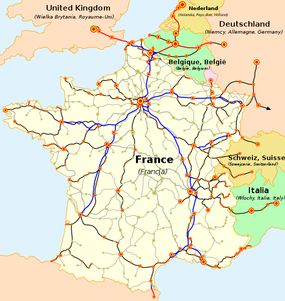
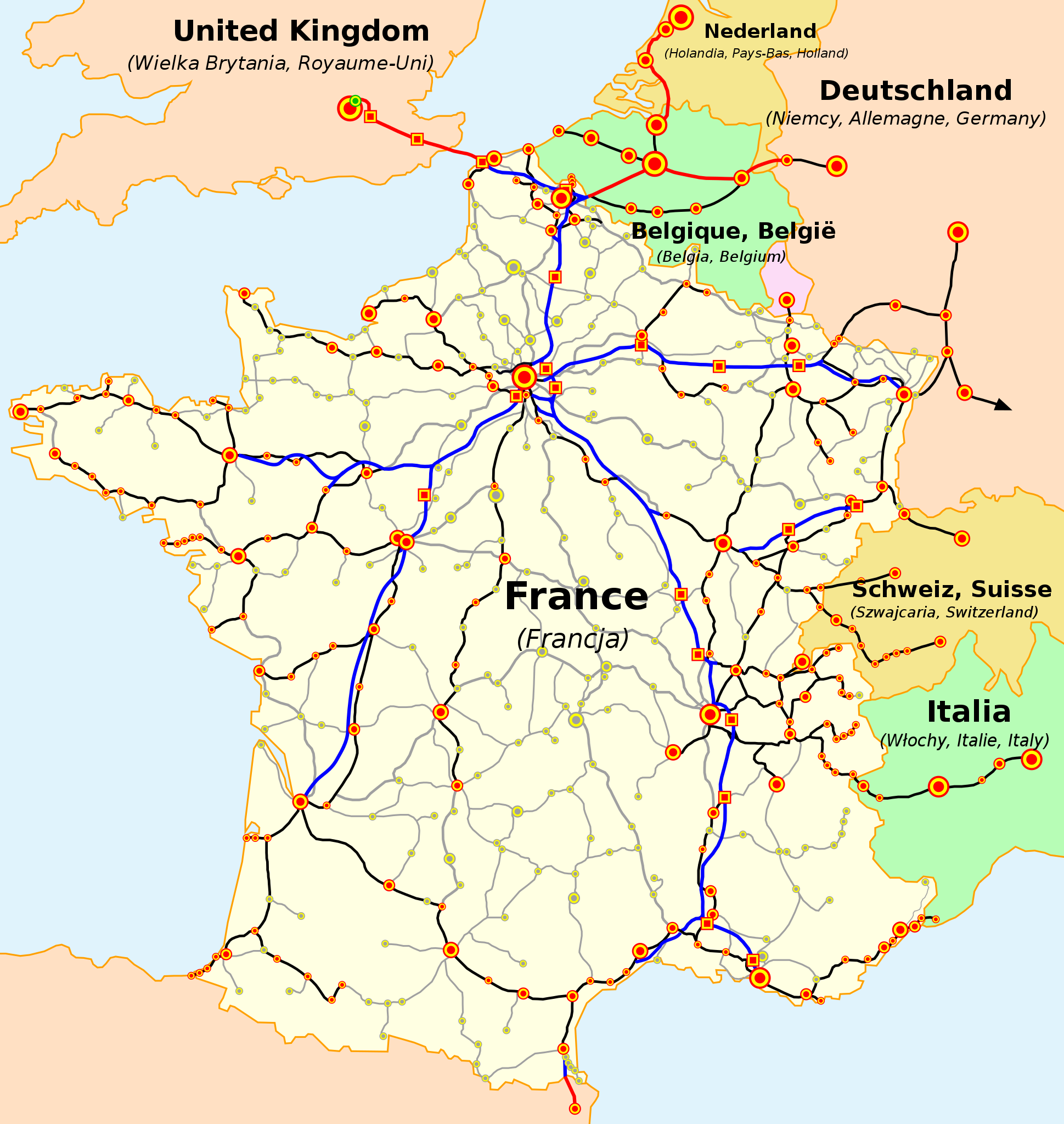
Français : La carte du réseau voyageurs de la SNCF, les TGV internationaux inclus
English: The map of French railways (SNCF) passengers service, including international TGV high-speed trains
Deutsch: Karte der französischen Eisenbahn (SNCF) mit TGV Hochgeschwindigkeitsnetz
Español: Mapa de las líneas de ferrocarril de la SNCF, incluidas las líneas de TGV (alta velocidad)
Čeština: Mapa tratí francouzských železnic (SNCF) s přepravou cestujících včetně mezinárodních spojení TGV
Nederlands: Kaart van de Franse Spoorwegen (SNCF), inclusief internationale TGV hogesnelheidstreinen
Polski: Mapa sieci połączeń pasażerskich kolei francuskich (SNCF), uwzlędniająca międzynarodowe połączenia pociągami TGV
Русский: Карта пассажирского железнодорожного транспорта Франции, включая международные скоростные поезда TGV
Slovenčina: Mapa tratí francúzskych železníc (SNCF) s prepravou cestujúcich a medzinárodných spojení TGV
Català: La xarxa TGV: -en blau i en vermell: línies d'alta velocitat, -en negre: línies clàssiques per on circulen trens TGV, -puntejat: línies en projecte (TGV Est)
(cs) Vysvětlivky
Velikost značek označuje přibližně velikost měst (de) Legende
(es) Leyenda
(en) Legend
(fr) Légende
(nl) Legenda
(pl) Legenda
(sk) Vysvetlivky
|
| 来源 | Map based on SNCF map published on its web site. Travail basé sur la carte du réseau publiée par la SNCF sur son site internet. Praca oparta na mapie opublikowanej na stronie internetowej firmy SNCF. Mapa je vytvorené na základe mapy SNCF publikovanej na tejto web stránke. |
| 作者 |
(en) Own work, author: madcap. |
| 其他版本 |
此文件衍生的作品: |
许可协议
[编辑]

|
已授权您依据自由软件基金会发行的无固定段落及封面封底文字(Invariant Sections, Front-Cover Texts, and Back-Cover Texts)的GNU自由文件许可协议1.2版或任意后续版本的条款,复制、传播和/或修改本文件。该协议的副本请见“GNU Free Documentation License”。 |
| 本文件采用知识共享署名-相同方式共享 3.0 未本地化版本许可协议授权。 | ||
| ||
| 本许可协议标签作为GFDL许可协议更新的组成部分被添加至本文件。 |
文件历史
点击某个日期/时间查看对应时刻的文件。
| 日期/时间 | 缩略图 | 大小 | 用户 | 备注 | |
|---|---|---|---|---|---|
| 当前 | 2023年1月5日 (四) 19:25 | | 1,000 × 1,056(992 KB) | Lojwe(留言 | 贡献) | Without frame |
| 2021年4月28日 (三) 14:52 |  | 1,000 × 1,056(994 KB) | Bech(留言 | 贡献) | Prolongement LGV mediterranée jusqu'à l'est de Montpellier | |
| 2017年7月2日 (日) 09:21 |  | 1,000 × 1,056(790 KB) | Clicgauche(留言 | 贡献) | Finalisation LGV Est le 11 décembre 2016 | |
| 2017年7月2日 (日) 09:16 |  | 1,000 × 1,056(791 KB) | Clicgauche(留言 | 贡献) | Ouverture LGV Bretagne-Pays de la Loire et LGV Sud Europe Atlantique le 2 juillet 2017 | |
| 2016年4月17日 (日) 15:17 |  | 1,000 × 1,056(1,019 KB) | Jack ma(留言 | 贡献) | correction Angoulême and Poitiers: no station directly on the new line between Tours and Bordeaux | |
| 2016年1月1日 (五) 07:22 |  | 1,000 × 1,056(1,021 KB) | Jack ma(留言 | 贡献) | correction Angoulême | |
| 2015年1月25日 (日) 00:06 |  | 1,000 × 1,056(1.05 MB) | Muselaar(留言 | 贡献) | ajout du barreau manquant entre Manheim et Karlsruhe, emprunté quotidiennement par les TGV Frankfurt-Marseille | |
| 2012年10月15日 (一) 13:49 |  | 1,000 × 1,056(1.04 MB) | Benjism89(留言 | 贡献) | - phase 2 de la LGV Rhin-Rhône (pas encore en construction), + phase LGV Est, LGV SEA et LGV BPL (en construction) | |
| 2011年12月18日 (日) 11:22 |  | 1,000 × 1,056(960 KB) | Pic-Sou(留言 | 贡献) | update, fix | |
| 2010年8月3日 (二) 20:13 |  | 1,000 × 1,056(949 KB) | Uwe Dedering(留言 | 贡献) | layers to separate text from the rest |
您不可以覆盖此文件。
文件用途
以下27个页面使用本文件:
- Atlas of France
- Railway lines
- TGV
- User:Chumwa/OgreBot/Potential transport maps/2016 April 11-20
- User:Chumwa/OgreBot/Potential transport maps/2017 July 1-10
- User:Chumwa/OgreBot/Public transport information/2016 April 11-20
- User:Chumwa/OgreBot/Public transport information/2016 January 1-10
- User:Chumwa/OgreBot/Public transport information/2017 July 1-10
- User:Chumwa/OgreBot/Public transport information/2021 April 21-30
- User:Chumwa/OgreBot/Public transport information/2023 January 1-10
- User:Chumwa/OgreBot/Transport Maps/2016 April 11-20
- User:Chumwa/OgreBot/Transport Maps/2016 January 1-10
- User:Chumwa/OgreBot/Transport Maps/2017 July 1-10
- User:Chumwa/OgreBot/Transport Maps/2021 April 21-30
- User:Chumwa/OgreBot/Transport Maps/2023 January 1-10
- User:Chumwa/OgreBot/Travel and communication maps/2016 April 11-20
- User:Chumwa/OgreBot/Travel and communication maps/2017 July 1-10
- User:Hoff1980/Rail transport in France/2016 April 11-20
- User:Hoff1980/Rail transport in France/2016 January 1-10
- Commons:Featured picture candidates/Image:Carte TGV.svg
- Commons:Featured picture candidates/Log/November 2007
- File:Carte TGV-fr.svg
- File:Carte TGV-hu.svg
- File:Carte TGV fr.svg
- File:Carte TGV he.svg
- File:LGV EST.svg
- Category:SNCF
全域文件用途
以下其他wiki使用此文件:
- ar.wikipedia.org上的用途
- ca.wikipedia.org上的用途
- cs.wikipedia.org上的用途
- da.wikipedia.org上的用途
- de.wikipedia.org上的用途
- en.wikipedia.org上的用途
- es.wikipedia.org上的用途
- es.wikivoyage.org上的用途
- fi.wikipedia.org上的用途
- fr.wikipedia.org上的用途
- fr.wikivoyage.org上的用途
- he.wikipedia.org上的用途
- ja.wikipedia.org上的用途
- ko.wikipedia.org上的用途
- lb.wikipedia.org上的用途
- mk.wikipedia.org上的用途
- ms.wikipedia.org上的用途
- nl.wikipedia.org上的用途
- oc.wikipedia.org上的用途
- pl.wikipedia.org上的用途
- pnb.wikipedia.org上的用途
- ro.wikipedia.org上的用途
- sh.wikipedia.org上的用途
- simple.wikipedia.org上的用途
- sk.wikipedia.org上的用途
- th.wikipedia.org上的用途
查看此文件的更多全域用途。