File:Carte administrative de djibouti.png
Jump to navigation
Jump to search

Size of this preview: 800 × 565 pixels. Other resolutions: 320 × 226 pixels | 640 × 452 pixels | 1,024 × 723 pixels | 1,121 × 792 pixels.
Original file (1,121 × 792 pixels, file size: 111 KB, MIME type: image/png)
Captions
Captions
Add a one-line explanation of what this file represents
Summary
[edit]
| Description |
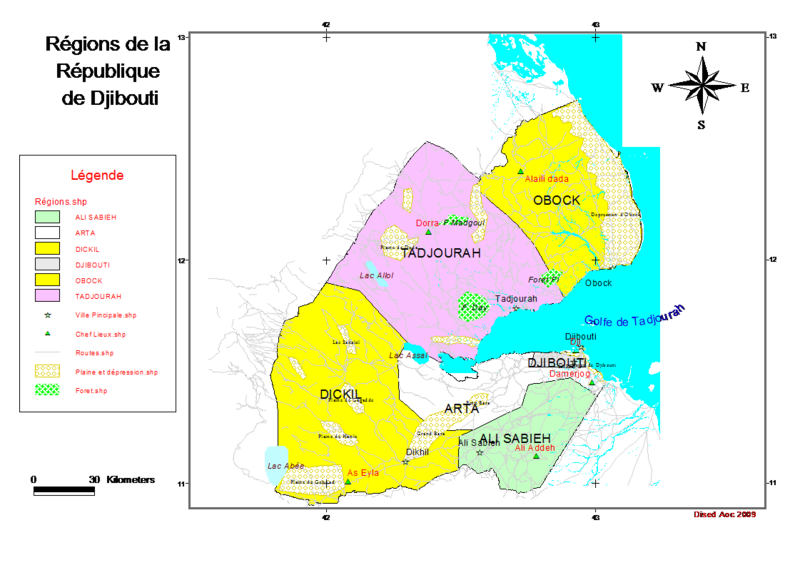
English: This map shows the spatial géographique occupation of the 6 régions in Djibouti Territory. |
| Date | |
| Source | Djibouti |
| Author | Abass Omar Chirdon |
I Abass Omar Chirdon author of this map, authorize the publication and edition in wiki.
Licensing
[edit]
| I, the copyright holder of this work, release this work into the public domain. This applies worldwide. In some countries this may not be legally possible; if so: I grant anyone the right to use this work for any purpose, without any conditions, unless such conditions are required by law. |
File history
Click on a date/time to view the file as it appeared at that time.
| Date/Time | Thumbnail | Dimensions | User | Comment | |
|---|---|---|---|---|---|
| current | 03:31, 15 August 2010 | | 1,121 × 792 (111 KB) | Nabadey (talk | contribs) | {{Information |Description={{en|1=This map shows the spatial géographique occupation of the 6 régions in Djibouti Territory. }} |Source=Djibouti |Author=Abass Omar Chirdon |Date=2009-01-23 |Permission= |other_versions= }} I Abass Omar Chirdon author of |
You cannot overwrite this file.
File usage on Commons
There are no pages that use this file.