File:Carte des Estats de Suede, de Dannemarq, et de Pologne; sur la Mer Baltique.jpg
Перайсьці да навігацыі
Перайсьці да пошуку

Памер прагляду: 483 × 599 піксэлаў. Іншыя разрозьненьні: 193 × 240 піксэлаў | 387 × 480 піксэлаў | 619 × 768 піксэлаў | 825 × 1024 піксэлаў | 1650 × 2048 піксэлаў | 2882 × 3576 піксэлаў.
Арыгінальны файл (2882 × 3576 піксэляў, памер файла: 5,12 Мб, тып MIME: image/jpeg)
Подпісы
Подпісы
Дадайце аднарадковае тлумачэньне, што зь сябе ўяўляе гэты файл
Апісаньне[рэдагаваць]
| Апісаньне |
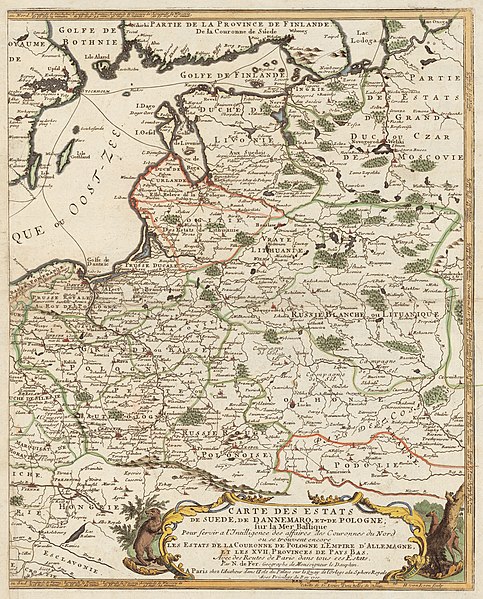
Carte des Estats de Suede, de Dannemarq, et de Pologne; sur la Mer Baltique English: Published in Paris by Nicolas de Fer in 1700. Copper engraving, ca 1:4 200 000, 35 x 43 cm.
The original map consists of two parts; the present is an Eastern part. Українська: Карта Польщі (Речі Посполитої до якої входила Волинь, Поділля) та Прибалтики видана в Парижі в 1700 році.
Масштаб 1:4 200 000, 35 x 43 см. Оригінальна мапа складається з двох частин. Lietuvių: Lietuvos Didžiosios kunigaikštystės žemėlapis su pažymėta Tikrąja Lietuva (Lithuania Proper) |
||||
| Дата | |||||
| Крыніца | http://www.nlib.ee/html/digi/maps/kaart00280.jpg, original in the National Library Cartography Collection | ||||
| Аўтар | Nicolas de Fer (1646-1720) | ||||
| Дазвол (Паўторнае выкарыстаньне гэтага файлу) |
|
||||
| Іншыя вэрсіі | |||||
_is_clearly_separated_with_a_green_line_from_Samogitia_(Samogitie),_and_the_Belarusian_territories_of_the_Grand_Duchy_of_Lithuania_(Russie_Blanche_ou_Lituanique).jpg)
Гісторыя файла
Націсьніце на дату/час, каб паглядзець, як тады выглядаў файл.
| Дата і час | Мініятура | Памеры | Удзельнік | Камэнтар | |
|---|---|---|---|---|---|
| цяперашняя | 04:56, 8 ліпеня 2008 | | 2882 × 3576 (5,12 Мб) | Albert Krantz (Абмеркаваньне | унёсак) | {{Information |Description=? |Source=? |Author=? |Date= |Permission= |other_versions= }} {{ImageUpload|full}} |
Вы ня можаце перазапісаць гэты файл.
Выкарыстаньне файла
Наступныя старонкі выкарыстоўваюць гэты файл:
Глябальнае выкарыстаньне файла
Гэты файл выкарыстоўваецца ў наступных вікі:
- Выкарыстаньне ў bg.wikipedia.org
- Выкарыстаньне ў cs.wikipedia.org
- Выкарыстаньне ў en.wikipedia.org
- Выкарыстаньне ў et.wikipedia.org
- Выкарыстаньне ў lt.wikipedia.org
- Выкарыстаньне ў lt.wikibooks.org
- Выкарыстаньне ў lv.wikipedia.org
- Выкарыстаньне ў uk.wikipedia.org
Мэтазьвесткі
Катэгорыі:
- Old maps of the Polish-Lithuanian Commonwealth
- 18th-century maps of Latvia
- 18th-century maps of Belarus
- 1700s maps of Ukraine
- 18th-century maps of Estonia
- Maps of Volhynia
- Maps of Podolia
- Red Ruthenia
- 1700s maps of Lithuania
- Maps by Nicolas de Fer
- Samogitia Voivodeship
- White Ruthenia
- 1700s maps of Grand Duchy of Lithuania
- 1700s maps of Eastern Europe