File:Carte parcs nationaux de france.jpg
Jump to navigation
Jump to search
Size of this preview: 800 × 583 pixels. Other resolutions: 320 × 233 pixels | 640 × 466 pixels | 1,024 × 746 pixels | 1,280 × 933 pixels | 1,564 × 1,140 pixels.
Original file (1,564 × 1,140 pixels, file size: 581 KB, MIME type: image/jpeg)
Captions
Captions
Add a one-line explanation of what this file represents
Summary
[edit]
| Description |
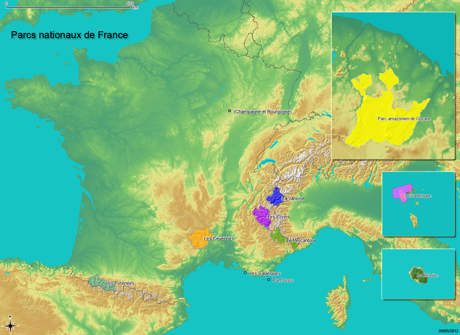
English: Map of the French national parks
Français : Carte des parcs nationaux de France |
| Date | |
| Source | Own work |
| Author | Delorme |
Le contour sur la carte représente un parc national soit l'ensemble composé d'un (ou plusieurs) cœur et d'une aire (optimale) d'adhésion.
- Fond topographique :
- Frontières :
- Lacs :
- Relief
Réalisé avec GDAL, GRASS et QGIS
Licensing
[edit]
I, the copyright holder of this work, hereby publish it under the following licenses:

|
Permission is granted to copy, distribute and/or modify this document under the terms of the GNU Free Documentation License, Version 1.2 or any later version published by the Free Software Foundation; with no Invariant Sections, no Front-Cover Texts, and no Back-Cover Texts. A copy of the license is included in the section entitled GNU Free Documentation License. |
This file is licensed under the Creative Commons Attribution-Share Alike 3.0 Unported, 2.5 Generic, 2.0 Generic and 1.0 Generic license.
- You are free:
- to share – to copy, distribute and transmit the work
- to remix – to adapt the work
- Under the following conditions:
- attribution – You must give appropriate credit, provide a link to the license, and indicate if changes were made. You may do so in any reasonable manner, but not in any way that suggests the licensor endorses you or your use.
- share alike – If you remix, transform, or build upon the material, you must distribute your contributions under the same or compatible license as the original.
You may select the license of your choice.
File history
Click on a date/time to view the file as it appeared at that time.
| Date/Time | Thumbnail | Dimensions | User | Comment | |
|---|---|---|---|---|---|
| current | 14:49, 9 May 2012 | | 1,564 × 1,140 (581 KB) | Oeneis (talk | contribs) | * Ajout Calanques * Modelé relief moins marqué |
| 14:47, 9 May 2012 |  | 1,564 × 1,140 (663 KB) | Oeneis (talk | contribs) | Reverted to version as of 20:29, 27 April 2011 erreur upload | |
| 14:45, 9 May 2012 |  | 1,564 × 1,140 (581 KB) | Oeneis (talk | contribs) | *Ajout Calanques *Dégradé relief moins prononcé | |
| 20:29, 27 April 2011 |  | 1,564 × 1,140 (663 KB) | Oeneis (talk | contribs) | Added lakes from [http://www.worldwildlife.org/science/data/item1877.html Global Lakes and Wetlands Database (GLWD-1) - Level 1] via [http://geodata.grid.unep.ch UNEP] Less contrast | |
| 20:28, 27 April 2011 |  | 1,564 × 1,140 (569 KB) | Oeneis (talk | contribs) | Reverted to version as of 15:27, 27 April 2011 bad contrast | |
| 20:25, 27 April 2011 |  | 1,564 × 1,140 (736 KB) | Oeneis (talk | contribs) | Added lakes from [http://www.worldwildlife.org/science/data/item1877.html Global Lakes and Wetlands Database (GLWD-1) - Level 1] via [http://geodata.grid.unep.ch UNEP] | |
| 15:27, 27 April 2011 |  | 1,564 × 1,140 (569 KB) | Oeneis (talk | contribs) | {{Information |Description ={{en|1=Map of the french national parks}} {{fr|1=Carte des parcs nationaux de France}} |Source ={{own}} |Author =Delorme |Date =2011-04-27 |Permission = |other_versions = }} * S |
You cannot overwrite this file.
File usage on Commons
There are no pages that use this file.
File usage on other wikis
The following other wikis use this file:
- Usage on ar.wikipedia.org
- Usage on cs.wikipedia.org
- Usage on es.wikipedia.org
- Usage on fr.wikipedia.org
- Usage on it.wikipedia.org
- Usage on ja.wikipedia.org
- Usage on nl.wikipedia.org
- Usage on ru.wikipedia.org
- Usage on sv.wikipedia.org
- Usage on uk.wikipedia.org