File:Carte pays Caux1.png
Jump to navigation
Jump to search

Size of this preview: 621 × 599 pixels. Other resolutions: 249 × 240 pixels | 497 × 480 pixels | 1,000 × 965 pixels.
Original file (1,000 × 965 pixels, file size: 215 KB, MIME type: image/png)
Captions
Captions
Add a one-line explanation of what this file represents
Summary
[edit]
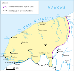
| Description | Carte du Pays de Caux, Seine-Maritime, France |
| Date | 2 November 2007 (upload date) |
| Source | Own work |
| Author | Urban |
Licensing
[edit]
| I, the copyright holder of this work, release this work into the public domain. This applies worldwide. In some countries this may not be legally possible; if so: I grant anyone the right to use this work for any purpose, without any conditions, unless such conditions are required by law. |
File history
Click on a date/time to view the file as it appeared at that time.
| Date/Time | Thumbnail | Dimensions | User | Comment | |
|---|---|---|---|---|---|
| current | 14:21, 2 November 2007 | | 1,000 × 965 (215 KB) | Urban~commonswiki (talk | contribs) | {{Information |Description=Carte du Pays de Caux, Seine-Maritime, France |Source=self-made |Date=02-11-2007 |Author= Urban }} Category:Pays de CauxCategory:Maps of Normandie |
You cannot overwrite this file.
File usage on Commons
There are no pages that use this file.
File usage on other wikis
The following other wikis use this file:
- Usage on br.wikipedia.org
- Usage on cs.wikipedia.org
- Usage on de.wikipedia.org
- Usage on el.wikipedia.org
- Usage on es.wikipedia.org
- Usage on fi.wikipedia.org
- Usage on fr.wikipedia.org
- Usage on nl.wikipedia.org
- Usage on pl.wikipedia.org
- Usage on ru.wikipedia.org