File:Carte peuples turcs.png
Skočit na navigaci
Skočit na vyhledávání

Velikost tohoto náhledu: 800 × 490 pixelů. Jiná rozlišení: 320 × 196 pixelů | 640 × 392 pixelů | 1 024 × 628 pixelů | 1 280 × 785 pixelů | 1 690 × 1 036 pixelů.
Původní soubor (1 690 × 1 036 pixelů, velikost souboru: 99 KB, MIME typ: image/png)
Popisky
Popisky
Přidejte jednořádkové vysvětlení, co tento soubor představuje


|
Tento obrázek (skupina map) by měl být vytvořen pomocí vektorové grafiky jako SVG soubor. To má několik výhod; podrobnosti najdete na stránce Commons:Media for cleanup. Je-li SVG verze tohoto obrázku již k dispozici, prosím nahrajte ji. Po nahrání nahraďte tuto šablonu šablonou {{Vector version available|jméno nového obrázku.svg}}.
|
| Popis |
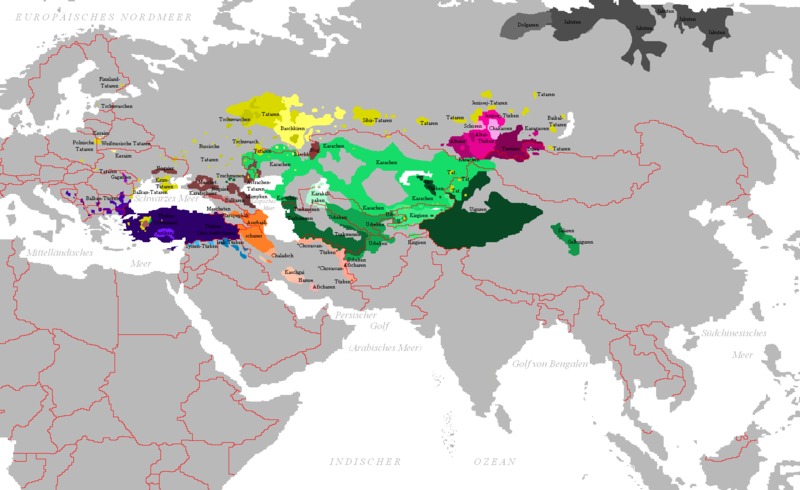
Català: Carta descripció de les llengües turques.
Deutsch: Karte der geographischer Verbreitung der Turksprachen.
Français : Carte de la répartition géographique des peuples de langues turques (turciques). Note : les libellés sont en allemand. |
||||||||||
| Datum | |||||||||||
| Zdroj | [:en:image:Carte_peuples_turcs.png] | ||||||||||
| Autor | en:User:Zaparojdik - See History below. | ||||||||||
| Svolení (Užití tohoto souboru) |
|


Původní historie souboru[editovat]
This image was moved from en:File:800px-Carte peuples turcs.png.
| date/time | username | resolution | size | edit summary |
|---|---|---|---|---|
| 2009-09-10T18:13:42Z | User:Korrigan | 1691×1037 | 126.44Kb | Higher resolution |
| 2006-10-04T08:35:18Z | User:Walden69 | 800×491 | 243.01Kb | Carta descripció de les Llengües turques, from English Wikipedia Source: [[en:image:Carte_peuples_turcs.png]] (del) (cur) 15:40, 22 August 2006 . . Zaparojdik (Talk | contribs) . . 800×491 (248,844 bytes) ({{GFDL}} TURKIC PEOPLES) |
A more detailed history can be tracked on the talk page. Warning : the actual source in German (before English Wikipedia where it was first imported under a French name) is still missing here.
Historie souboru
Kliknutím na datum a čas se zobrazí tehdejší verze souboru.
| Datum a čas | Náhled | Rozměry | Uživatel | Komentář | |
|---|---|---|---|---|---|
| současná | 20. 7. 2021, 14:43 | | 1 690 × 1 036 (99 KB) | MicBy67 (diskuse | příspěvky) | Reverted to version as of 17:50, 16 May 2020 (UTC) |
| 16. 5. 2020, 22:06 |  | 1 690 × 1 036 (103 KB) | Satoshi Kondo (diskuse | příspěvky) | Reverted to version as of 02:07, 5 April 2020 (UTC) | |
| 16. 5. 2020, 17:50 |  | 1 690 × 1 036 (99 KB) | SahinCcC (diskuse | příspěvky) | Reverted to version as of 23:11, 2 April 2020 (UTC) | |
| 5. 4. 2020, 02:07 |  | 1 690 × 1 036 (103 KB) | Satoshi Kondo (diskuse | příspěvky) | Reverted to version as of 17:52, 26 November 2019 (UTC) ? | |
| 2. 4. 2020, 23:11 |  | 1 690 × 1 036 (99 KB) | LenguaMapa (diskuse | příspěvky) | exclude fuyu kirgiz in Manchuria, mostly extinct today (not even 0,1% of total population). fixed distribution of anatolian turks | |
| 26. 11. 2019, 17:52 |  | 1 690 × 1 036 (103 KB) | Maphobbyist (diskuse | příspěvky) | Reverted to version as of 13:04, 1 May 2019 (UTC) | |
| 20. 10. 2019, 13:30 |  | 1 280 × 785 (362 KB) | LenguaMapa (diskuse | příspěvky) | Correction on Yakuts and Dolgans | |
| 24. 9. 2019, 22:36 |  | 1 690 × 1 036 (100 KB) | LenguaMapa (diskuse | příspěvky) | minor corrections, more accurate now | |
| 1. 5. 2019, 13:04 |  | 1 690 × 1 036 (103 KB) | Satoshi Kondo (diskuse | příspěvky) | Fuyu-Kirgisen, Hunan-Salaren, correction on Sakha-Yakuts distribution, Ürümqi(Xinjiang) | |
| 30. 1. 2019, 06:34 |  | 1 690 × 1 036 (126 KB) | MicBy67 (diskuse | příspěvky) | Reverted to version as of 15:43, 20 September 2018 (UTC). Bitte KEINEN EW führen. Es ist Usus, diese Gebiete in der Fachliteratur zu weißen oder mit schwächeren Farben als dünnbesiedelt zu kennzeichnen. |
Tento soubor nemůžete přepsat.
Využití souboru
Na Commons na soubor odkazují tyto stránky:
- User:Chumwa/OgreBot/Travel and communication maps/2018 April 21-30
- User:Chumwa/OgreBot/Travel and communication maps/2018 August 21-31
- User:Chumwa/OgreBot/Travel and communication maps/2018 June 21-30
- User:Chumwa/OgreBot/Travel and communication maps/2018 September 11-20
- User:Chumwa/OgreBot/Travel and communication maps/2019 January 1-10
- User:Chumwa/OgreBot/Travel and communication maps/2019 January 21-31
- User:Chumwa/OgreBot/Travel and communication maps/2019 November 21-30
- User:Chumwa/OgreBot/Travel and communication maps/2019 October 11-20
- User:Chumwa/OgreBot/Travel and communication maps/2019 September 21-30
- User:Chumwa/OgreBot/Travel and communication maps/2020 April 1-10
- User:Chumwa/OgreBot/Travel and communication maps/2020 May 11-20
- User:Chumwa/OgreBot/Travel and communication maps/2021 July 11-20
- File:Distribution of Türkic people map.jpg
Globální využití souboru
Tento soubor využívají následující wiki:
- Využití na af.wikipedia.org
- Využití na azb.wikipedia.org
- Využití na ca.wikipedia.org
- Využití na cs.wikipedia.org
- Využití na de.wikipedia.org
- Využití na el.wikipedia.org
- Využití na en.wikipedia.org
- Využití na es.wikipedia.org
- Využití na et.wikipedia.org
- Využití na fa.wikipedia.org
- Využití na frr.wikipedia.org
- Využití na fy.wikipedia.org
- Využití na gv.wikipedia.org
- Využití na hak.wikipedia.org
- Využití na ha.wikipedia.org
- Využití na hu.wikipedia.org
- Využití na io.wikipedia.org
- Využití na ja.wikipedia.org
- Využití na ko.wikipedia.org
- Využití na la.wikipedia.org
- Využití na lfn.wikipedia.org
- Využití na nl.wikipedia.org
- Využití na nl.wiktionary.org
- Využití na pa.wikipedia.org
- Využití na pl.wikipedia.org
- Využití na pnb.wikipedia.org
- Využití na pt.wikipedia.org
- Využití na ru.wikipedia.org
- Využití na sco.wikipedia.org
- Využití na sv.wikipedia.org
- Využití na tr.wikipedia.org
- Využití na uk.wikipedia.org
- Využití na ur.wikipedia.org
- Využití na vi.wikipedia.org