File:Map Kingdom of Brittany 845-867-de.svg
(Redirected from File:Carte royaume Bretagne de.svg)

Size of this PNG preview of this SVG file: 707 × 599 pixels. Other resolutions: 283 × 240 pixels | 566 × 480 pixels | 906 × 768 pixels | 1,208 × 1,024 pixels | 2,416 × 2,048 pixels | 736 × 624 pixels.
Original file (SVG file, nominally 736 × 624 pixels, file size: 250 KB)
Captions
Captions
Add a one-line explanation of what this file represents
| Description |
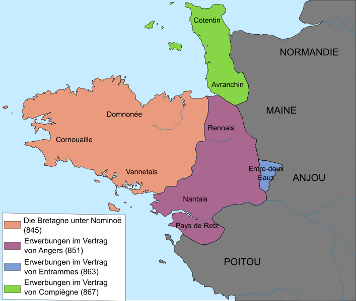
Deutsch: Ungefähre Grenzen des betonischen Königreichs (845-867).
Français : Frontières approximatives du royaume de Bretagne (845-867). English: Approximate borders of the Brittany kingdom (845-867). Lambert-93 projection ; RGF-93 datum ; Scale: 1:2,000,000 |
| Date | (UTC) |
| Source | |
| Author |
|
| Other versions |
[]
|


| This is a retouched picture, which means that it has been digitally altered from its original version. Modifications: traduction allemand /deutsche Übersetzung. The original can be viewed here: Carte royaume Bretagne.svg:
|
I, the copyright holder of this work, hereby publish it under the following licenses:
This file is licensed under the Creative Commons Attribution-Share Alike 3.0 Unported, 2.5 Generic, 2.0 Generic and 1.0 Generic license.
- You are free:
- to share – to copy, distribute and transmit the work
- to remix – to adapt the work
- Under the following conditions:
- attribution – You must give appropriate credit, provide a link to the license, and indicate if changes were made. You may do so in any reasonable manner, but not in any way that suggests the licensor endorses you or your use.
- share alike – If you remix, transform, or build upon the material, you must distribute your contributions under the same or compatible license as the original.

|
Permission is granted to copy, distribute and/or modify this document under the terms of the GNU Free Documentation License, Version 1.2 or any later version published by the Free Software Foundation; with no Invariant Sections, no Front-Cover Texts, and no Back-Cover Texts. A copy of the license is included in the section entitled GNU Free Documentation License. |
You may select the license of your choice.
Original upload log[edit]
This image is a derivative work of the following images:
- File:Carte_royaume_Bretagne.svg licensed with Cc-by-sa-3.0,2.5,2.0,1.0, GFDL
- 2010-11-14T12:39:20Z Fab5669 736x624 (82357 Bytes) {{Information |Description={{fr|1=Carte du royaume de Bretagne (845-867)}} {{en|1=Map of the Brittany kingdom (845-867)}} |Source={{own}} |Author=[[User:Fab5669|Fab5669]] |Date=14 novembre 2010 |Permission= |other_versions= }
Uploaded with derivativeFX
File history
Click on a date/time to view the file as it appeared at that time.
| Date/Time | Thumbnail | Dimensions | User | Comment | |
|---|---|---|---|---|---|
| current | 14:10, 14 November 2010 | | 736 × 624 (250 KB) | Furfur (talk | contribs) | {{Information |Description={{de|Ungefähre Grenzen des betonischen Königreichs (845-867).}} {{fr|Frontières approximatives du royaume de Bretagne (845-867).}} {{en|Approximate borders of the Brittany kingdom (845-867).}} Lambert-93 projection ; RGF-93 d |
You cannot overwrite this file.
File usage on Commons
The following 7 pages use this file:
- File:Carte royaume Bretagne de.svg (file redirect)
- File:Map Kingdom of Brittany 845-867-br.svg
- File:Map Kingdom of Brittany 845-867-de.svg
- File:Map Kingdom of Brittany 845-867-es.svg
- File:Map Kingdom of Brittany 845-867-fr.svg
- File:Map Kingdom of Brittany 845-867-hu.svg
- Template:Other versions/Map Kingdom of Brittany 845-867
File usage on other wikis
The following other wikis use this file:
- Usage on de.wikipedia.org