File:Cartouche in a Latvia map by the Russian Academy.jpg
Pāriet uz navigāciju
Pāriet uz meklēšanu

Šī priekšskata izmērs: 400 × 600 pikseļi. Citi izmēri: 160 × 240 pikseļi | 320 × 480 pikseļi | 512 × 768 pikseļi | 683 × 1 024 pikseļi | 1 597 × 2 395 pikseļi.
Sākotnējais fails (1 597 × 2 395 pikseļi, faila izmērs: 612 KB, MIME tips: image/jpeg)
Captions
Captions
Pievieno vienas rindiņas aprakstu, ko šis fails attēlo
| Warning | The original file is very high-resolution. It might not load properly or could cause your browser to freeze when opened at full size. |
|---|
Kopsavilkums
[labot šo sadaļu]| Apraksts |
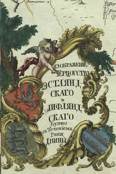
Русский: Первый официальный атлас Российской империи (1745). Карта герцогств Эстляндского и Лифляндского, вместе с течением реки Двины. Оригинальная карта гравирована на меди и раскрашена вручную акварелью.
English: First official geographic atlas of the Russian Empire (1745). Map of Estland and Livland duchies, include Dvina river. Hand-coloured copper engraving. |
| Datums | |
| Avots |
Русский: Атлас Российский (1745)
English: Geographic atlas of the Russian Empire (1745) |
| Autors | РАН (Russian Academy of Science) |
| Citas versijas |
|
.jpg)
.jpg)
.jpg)
.jpg)
.jpg)
Licence
[labot šo sadaļu]
|
This work is in the public domain in its country of origin and other countries and areas where the copyright term is the author's life plus 100 years or fewer. | |
| This file has been identified as being free of known restrictions under copyright law, including all related and neighboring rights. | |
Faila hronoloģija
Uzklikšķini uz datums/laiks kolonnā esošās saites, lai apskatītos, kā šis fails izskatījās tad.
| Datums/Laiks | Attēls | Izmēri | Dalībnieks | Komentārs | |
|---|---|---|---|---|---|
| tagadējais | 2022. gada 22. decembris, plkst. 14.36 | | 1 597 × 2 395 (612 KB) | Enyavar (diskusija | devums) | File:Russian Empire 1745 (Map III HQ).jpg cropped 83 % horizontally, 71 % vertically using CropTool with precise mode. |
Šo failu nevar pārrakstīt.
Faila lietojums
Šo failu izmanto šajā 1 lapā: