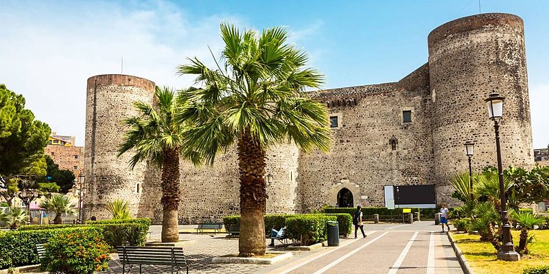
File:Castello Ursino di Catania progettato da Riccardo da Lentini.jpg

Original file (1,186 × 591 pixels, file size: 215 KB, MIME type: image/jpeg)
Captions
Captions
Summary[edit]
| DescriptionCastello Ursino di Catania progettato da Riccardo da Lentini.jpg |
Italiano: Il Castello Ursino venne edificato nel XIII sec. ad opera di Federico II di Svevia che ne affidò l’incarico all’arch. Riccardo da Lentini che lo fece divenire un simbolo della città.
Si sviluppa su base quadrata con agli angoli 4 torrioni circolari e 4 torri mediane poste lungo le facciate. Delle quattro torri mediane, due sono state avvolte dalla lava e quindi non sono più visibili. Il Castello era dotato di un fossato e di una scarpa alla base che lo rendeva molto imponente. Le mura del Castello sono erette in pietra lavica. In principio il castello non aveva finestre, che ne avrebbero indebolito il suo potere difensivo, ma quando il castello perse il suo ruolo principale ne vennero aperte diverse. Sull’ingresso del Castello nella facciata a nord, vi è una raffigurazione dell’aquila sveva, simbolo di Federico II. Nel 1669 il Castello venne raggiunto dalla lava a seguito di un’eruzione dell’Etna che ne riempì il fossato e coprì i bastioni mediani.Sicilianu: U casteddu Ursino vinni fattu 'ndo triricesumu seculu pi vuliri ri Federicu II (Sicunnu) ri Svevia ca ci resi l'incaricu all'architettu Riccardo da Lentini ca u fici divintari simbulu ri la città.
U casteddu iavi basi quatrata e 'nda l'angoli quattru torrioni circolari e quattru torri minzani misi ri ciangu 'e facciati. De' quattru torri minzani, rui ana statu cummigghiati ra' lava e 'nfatti nun si virunu chiù. Prima c'era 'nfossatu e nu basamentu ca u rinnevunu assai imponente. I mura ro Casteddu su ri petra lavica. All'iniziu u Casteddu nun aveva finestri, pi difinissiri megghiu, ma quannu pessi u so ruolu principali ni ficiuni diversi. 'Nda l'ingressu ro Casteddu, 'nda facciata a nord, c'è n'acquila sveva, ca è u simbulu ri Federicu Sicunnu. I du torri minzani e u fossatu fonu cummighiati ra' lava 'ndo 1669. |
| Date | |
| Source | Own work |
| Author | Dardoc10 |
| Camera location | 37° 29′ 57.15″ N, 15° 05′ 04.17″ E | View this and other nearby images on: OpenStreetMap |
|---|
Licensing[edit]
- You are free:
- to share – to copy, distribute and transmit the work
- to remix – to adapt the work
- Under the following conditions:
- attribution – You must give appropriate credit, provide a link to the license, and indicate if changes were made. You may do so in any reasonable manner, but not in any way that suggests the licensor endorses you or your use.
- share alike – If you remix, transform, or build upon the material, you must distribute your contributions under the same or compatible license as the original.
File history
Click on a date/time to view the file as it appeared at that time.
| Date/Time | Thumbnail | Dimensions | User | Comment | |
|---|---|---|---|---|---|
| current | 10:58, 2 May 2023 |  | 1,186 × 591 (215 KB) | Dardoc10 (talk | contribs) | Uploaded own work with UploadWizard |
You cannot overwrite this file.
File usage on Commons
There are no pages that use this file.
File usage on other wikis
The following other wikis use this file:
- Usage on it.wikipedia.org
Metadata
This file contains additional information such as Exif metadata which may have been added by the digital camera, scanner, or software program used to create or digitize it. If the file has been modified from its original state, some details such as the timestamp may not fully reflect those of the original file. The timestamp is only as accurate as the clock in the camera, and it may be completely wrong.
| Width | 1,186 px |
|---|---|
| Height | 591 px |
| Horizontal resolution | 96 dpi |
| Vertical resolution | 96 dpi |