File:Catastrophic floods near Sydney, Australia.jpg

Original file (4,500 × 2,540 pixels, file size: 5.65 MB, MIME type: image/jpeg)
Captions
Captions
Summary[edit]
| Description |
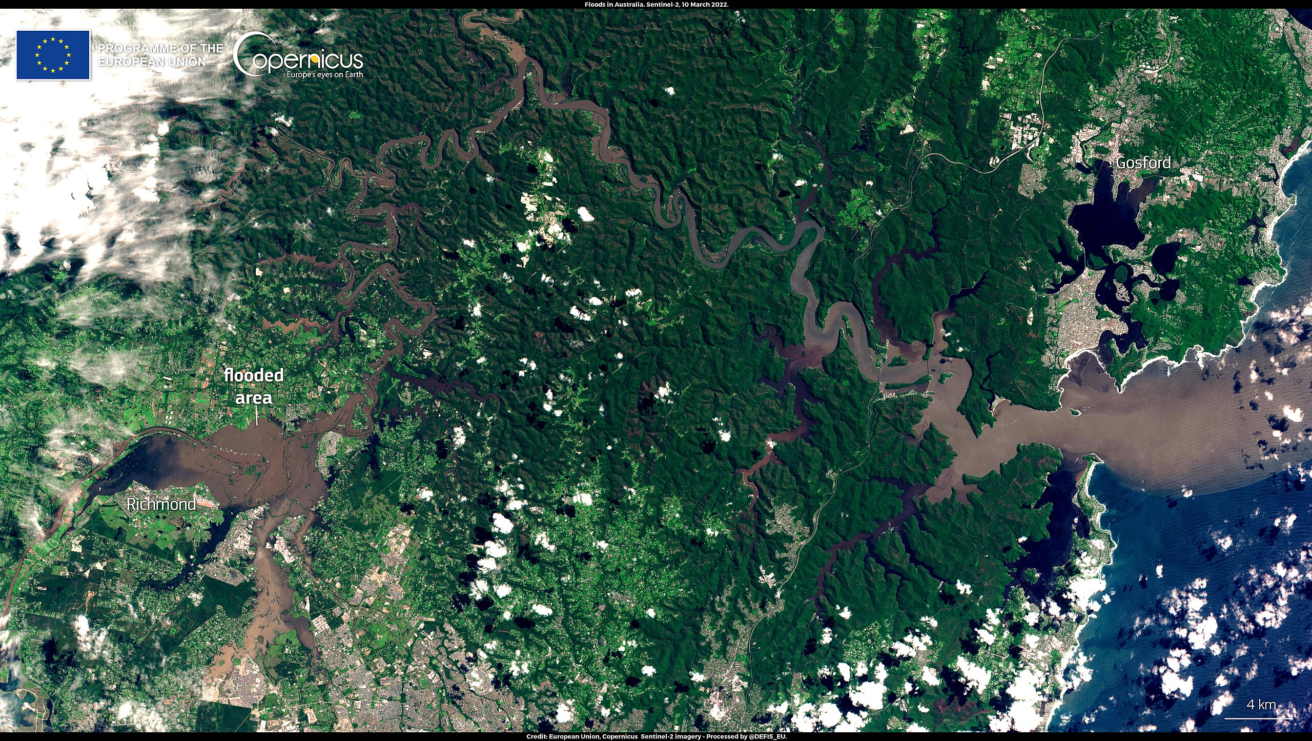
English: The states of Queensland and New South Wales in Australia have been experiencing prolonged rainfall that has caused a historical flooding event with catastrophic consequences. In Sydney, the capital of New South Wales and Australia’s most populous city, more than a year’s worth of rainfall poured down within a week, destroying property and sweeping away roads and livestock. To date, the death toll caused by the flood has risen to 20, while tens of thousands of people have been forced to evacuate their homes. The flooded area north of Sydney is visible on this image, acquired by one of the Copernicus Sentinel-2 satellites on 10 March 2022. The Copernicus Emergency Management Service (EMS) delivers Rapid Mapping products, providing geospatial information within hours or days of a service request, in order to support emergency management activities in the immediate aftermath of a disaster. An activation on Copernicus EMS for the floods in Queensland has been ongoing since late February. |
| Date | Taken on 10 March 2022 |
| Source | Catastrophic floods near Sydney, Australia |
| Author | European Union, Copernicus Sentinel-2 imagery |
Licensing[edit]

|
This image contains data from a satellite in the Copernicus Programme, such as Sentinel-1, Sentinel-2 or Sentinel-3. Attribution is required when using this image.
Attribution: Contains modified Copernicus Sentinel data 2022
The use of Copernicus Sentinel Data is regulated under EU law (Commission Delegated Regulation (EU) No 1159/2013 and Regulation (EU) No 377/2014). Relevant excerpts:
Free access shall be given to GMES dedicated data [...] made available through GMES dissemination platforms [...].
Access to GMES dedicated data [...] shall be given for the purpose of the following use in so far as it is lawful:
GMES dedicated data [...] may be used worldwide without limitations in time.
GMES dedicated data and GMES service information are provided to users without any express or implied warranty, including as regards quality and suitability for any purpose. |
File history
Click on a date/time to view the file as it appeared at that time.
| Date/Time | Thumbnail | Dimensions | User | Comment | |
|---|---|---|---|---|---|
| current | 21:15, 31 August 2023 | | 4,500 × 2,540 (5.65 MB) | OptimusPrimeBot (talk | contribs) | #Spacemedia - Upload of https://www.copernicus.eu/system/files/2022-03/image_day/20220311_FloodsInAustralia.jpg via Commons:Spacemedia |
You cannot overwrite this file.
File usage on Commons
There are no pages that use this file.