File:Catlin Illinois Trail of Death marker (cropped).png
Jump to navigation
Jump to search

Size of this preview: 800 × 544 pixels. Other resolutions: 320 × 218 pixels | 640 × 435 pixels | 1,125 × 765 pixels.
Original file (1,125 × 765 pixels, file size: 1.52 MB, MIME type: image/png)
Captions
Captions
Add a one-line explanation of what this file represents
Summary
[edit]| Camera location | | View this and other nearby images on: OpenStreetMap |
|---|
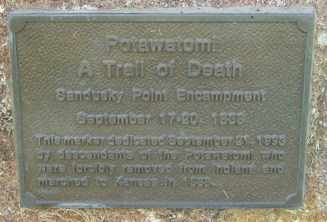
| Description | Trail of Death marker in Catlin, Illinois |
| Date | |
| Source | Self-photographed |
| Author | Omnedon |

.png&action=edit§ion=1)
.png¶ms=040.068564_N_-087.701036_E_globe:Earth_type:camera_region:US-IL_heading:225.00&language=en)
Licensing
[edit].png&action=edit§ion=2)
| I, the copyright holder of this work, release this work into the public domain. This applies worldwide. In some countries this may not be legally possible; if so: I grant anyone the right to use this work for any purpose, without any conditions, unless such conditions are required by law. |
File history
Click on a date/time to view the file as it appeared at that time.
| Date/Time | Thumbnail | Dimensions | User | Comment | |
|---|---|---|---|---|---|
| current | 02:53, 26 May 2022 | | 1,125 × 765 (1.52 MB) | Smuckola (talk | contribs) | File:Catlin Illinois Trail of Death marker.png cropped 25 % horizontally, 32 % vertically using CropTool with precise mode. |
You cannot overwrite this file.
File usage on Commons
The following page uses this file:
File usage on other wikis
The following other wikis use this file:
- Usage on en.wikipedia.org
.png&oldid=851677764)