File:Caucasus topo map-blank.svg
Pāriet uz navigāciju
Pāriet uz meklēšanu

Size of this PNG preview of this SVG file: 771 × 599 pikseļi. Citi izmēri: 309 × 240 pikseļi | 618 × 480 pikseļi | 988 × 768 pikseļi | 1 280 × 995 pikseļi | 2 560 × 1 990 pikseļi | 1 155 × 898 pikseļi.
Sākotnējais fails (SVG fails, definētais izmērs 1 155 × 898 pikseļi, faila izmērs: 4,43 MB)
Captions
Captions
Pievieno vienas rindiņas aprakstu, ko šis fails attēlo
Kopsavilkums
[labot šo sadaļu]| Apraksts |
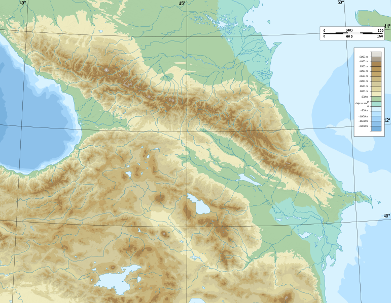
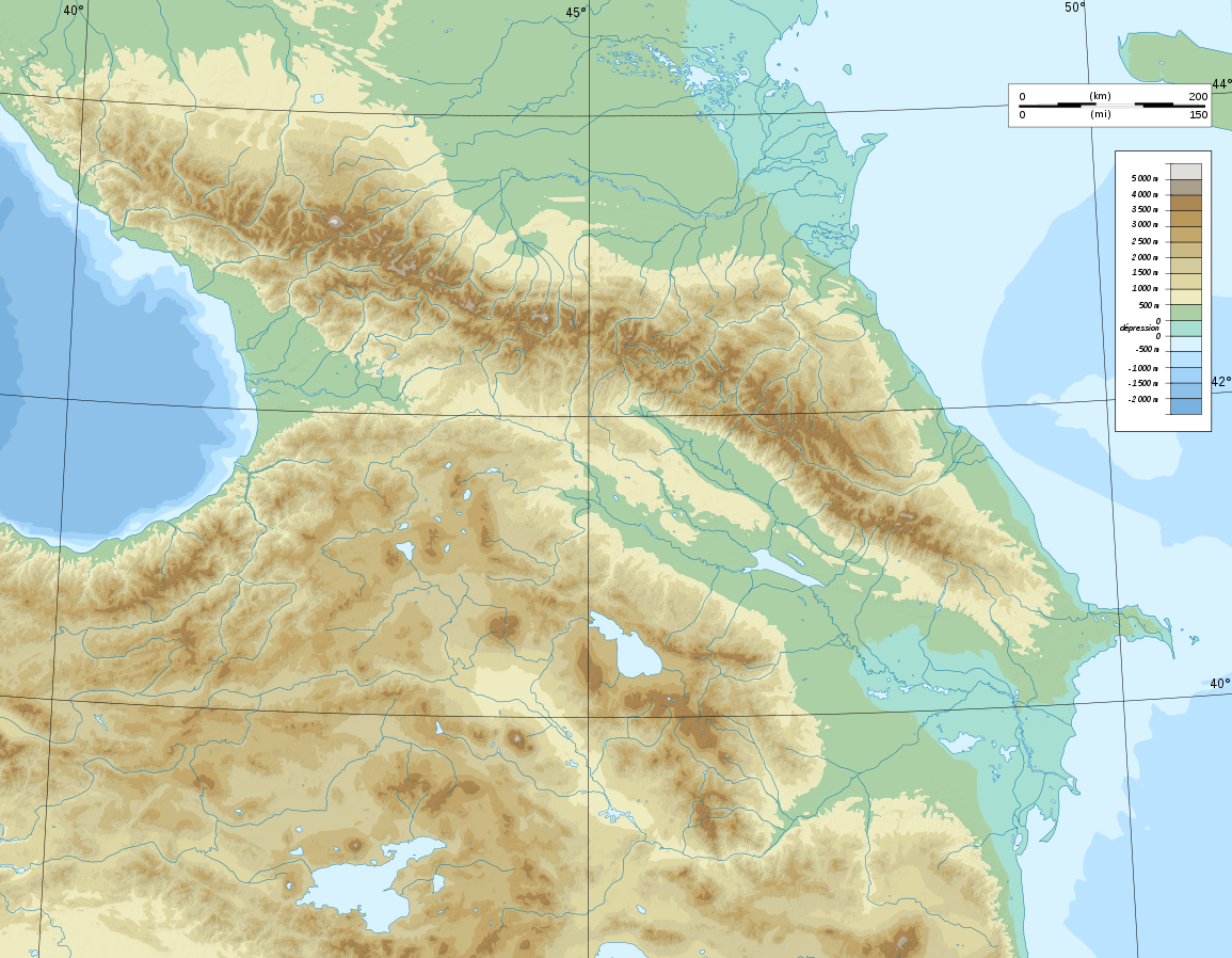
Deutsch: Topographische Karte von Kaukasien, französische Version English: Topographic map in French of Caucasus Français : Carte topographique en français du Caucase |
| Datums | |
| Avots |
English: Own work ; Topographic data from the NASA Shuttle Radar Topography Mission (SRTM3 v.2) (public domain) edited with 3DEM, reprojected in UTM with GDAL (GDAL), and vectorized with Inkscape ; UTM projection ; WGS84 datum ; shaded relief (composite image of N-W, W and N lightning positions) ; Reference used for the additional data : * Rivers, bathymetry : Demis add-on for World Wind (see the approval e-mail and the Demis forum) ; * coast : World data bank II ; Approximate scale of topographic data : 1:1,463,000 ; Note : The shaded relief is a raster image embedded in the SVG file. Français : Création personnelle ; Données topographiques de la NASA Shuttle Radar Topography Mission (SRTM3 v.2) (domaine public) éditées avec 3DEM, reprojetées en UTM avec GDAL et vectorisées avec Inkscape ; projection UTM ; WGS84 datum ; relief ombré (image composite d'éclairages du N-O, O et N) ; Références utilisées pour les données complémentaires : * Rivières, bathymétrie : Demis add-on for World Wind (cf. l'e-mail d'approbation de Demis et le Demis forum) ; * côtes : World data bank II ; Échelle approximative des données topographiques : 1:1 463 000 ; Note : Le relief ombré est une image bitmap embarquée dans le fichier SVG. Approximate geographic limits of the map (3' close) : * SW corner : 38°05'00"N – 39°33'00"E * SE corner : 38°05'00"N – 51°00'00"E * NE corner : 45°00'00"N – 51°00'00"E * NW corner : 45°00'00"N – 39°00'00"E |
| Autors | Bourrichon - fr:Bourrichon) |
| Atļauja: (Šī faila izmantošana citur) |
GFDL / Attribution and Share-Alike required |
| Citas versijas |
|


|
This SVG file contains embedded text that can be translated into your language, using any capable SVG editor, text editor or the SVG Translate tool. For more information see: About translating SVG files. |
Licence
[labot šo sadaļu]
Es, šī darba autortiesību īpašnieks, publicēju to saskaņā ar šīm licencēm:

|
Ir dota atļauja kopēt, izplatīt un/vai pārveidot šo dokumentu saskaņā ar GNU brīvās dokumentācijas licences, versijas 1.2 vai jebkuras vēlākas versijas, ko publiskojis Brīvās programmatūras fonds nosacījumiem; bez nemainīgajām sadaļā, priekšējā un aizmugurēja'vāka tekstiem. Licences kopija ir iekļauta sadaļā ar nosaukumu GNU brīvās dokumentācijas licence. |
This file is licensed under the Creative Commons Attribution-Share Alike Attribution-Share Alike 4.0 International, 3.0 Unported, 2.5 Generic, 2.0 Generic and 1.0 Generic license.
- Jūs varat brīvi:
- koplietot – kopēt, izplatīt un pārraidīt darbu
- remiksēt – pielāgot darbu
- Saskaņā ar šādiem nosacījumiem:
- atsaucoties – Tev ir jānorāda autors, saite uz licenci un to, vai veiktas kādas izmaiņas. To var darīt jebkādā saprātīgā veidā, bet ne tādā, kas norādītu, ka licencētājs atbalsta tevi vai veidu, kā tu izmanto šo darbu.
- nemainot licenci – Ja tu miksē, pārveido vai izmanto materiālu, tev savs devums jāpublicē ar to pašu vai saderīgu licenci kā oriģināls.
Jūs varat izvēlēties licenci pēc jūsu vēlmes.
Faila hronoloģija
Uzklikšķini uz datums/laiks kolonnā esošās saites, lai apskatītos, kā šis fails izskatījās tad.
| Datums/Laiks | Attēls | Izmēri | Dalībnieks | Komentārs | |
|---|---|---|---|---|---|
| tagadējais | 2008. gada 9. novembris, plkst. 17.16 | | 1 155 × 898 (4,43 MB) | Bourrichon (diskusija | devums) | |
| 2008. gada 8. novembris, plkst. 15.59 |  | 1 155 × 898 (4,43 MB) | Bourrichon (diskusija | devums) | == Summary == {{Information |Description={{de|Topographische Karte von Kaukasien, französische Version}}{{en|Topographic map in French of Caucasus}}{{fr|Carte topographique en français du Caucase}} |Sou |
Šo failu nevar pārrakstīt.
Faila lietojums
Šo failu izmanto šajās 26 lapās:
- File:Azerbaijan topographic map-fr.svg
- File:Azerbaijan topographic map-it.svg
- File:Azerbaijan topographic map-lt.svg
- File:Azerbaijan topographic map-mk.svg
- File:Caucasus by night.svg
- File:Caucasus hydro map-fr.svg
- File:Caucasus mountain range map-fr.svg
- File:Caucasus topo map-blank.jpg
- File:Caucasus topo map-blank.svg
- File:Caucasus topographic map-ar.png
- File:Caucasus topographic map-av.png
- File:Caucasus topographic map-fr.png
- File:Caucasus topographic map-fr.svg
- File:Caucasus topographic map-ru.svg
- File:Chechnya topographic map-fr.svg
- File:Dagestan topographic map-ar.png
- File:Dagestan topographic map-ce.svg
- File:Dagestan topographic map-fr.svg
- File:Dagestan topographic map-lt.svg
- File:Dagestan topographic map-ru.svg
- File:Georgia administrative map-fr.svg
- File:Georgia topographic map-fr.svg
- File:North Caucasus topographic map-es.svg
- File:North Caucasus topographic map-fr.svg
- Category:Caucasus mountains
- Category:Sochi National Park
Globālais faila lietojums
Šīs Vikipēdijas izmanto šo failu:
- Izmantojums ar.wikipedia.org
- Izmantojums ast.wikipedia.org
- Izmantojums av.wikipedia.org
- Izmantojums az.wikipedia.org
- Azərbaycan dili
- Muğan düzü
- Araz
- Böyük Qafqaz
- Kür
- Göygöl (göl)
- Bazardüzü
- Şablon:Çay
- Ağrı dağı
- Qarayazı Dövlət Təbiət Qoruğu
- Göygöl Dövlət Təbiət Qoruğu
- İlisu Dövlət Təbiət Qoruğu
- Mingəçevir su anbarı
- Hacıqabul gölü
- Türyançay Dövlət Təbiət Qoruğu
- Talış dağları
- Kürəkçay
- Qabırrıçay
- Qanıxçay
- Sumqayıtçay
- İlandağ
- Göyçə gölü
- Göyəzən dağı
- Şablon:Yer xəritəsi
- Şablon:Yer xəritəsi/doc
- Şablon:Yer xəritəsi+
- Xınalıq dağı
- Qafqaz dağları
- Murovdağ
- Kəpəz dağı
- Sarısu gölü
- Böyükşor gölü
- Maralgöl
- Şablon:Su anbarı
- Şablon:Su anbarı/doc
- Candargöl
- Kazbek dağı
- Şirvan düzü
- Mil düzü
- Batabat gölü
- Beşbarmaq dağı
- Babazənən yüksəkliyi
Skatīt šī faila pilno globālo izmantojumu.