File:Caucasus topo map-blank.svg
跳至導覽
跳至搜尋

此 SVG 檔案的 PNG 預覽的大小:771 × 599 像素。 其他解析度:309 × 240 像素 | 618 × 480 像素 | 988 × 768 像素 | 1,280 × 995 像素 | 2,560 × 1,990 像素 | 1,155 × 898 像素。
原始檔案 (SVG 檔案,表面大小:1,155 × 898 像素,檔案大小:4.43 MB)
說明
說明
添加單行說明來描述出檔案所代表的內容
摘要
[編輯]| 描述 |
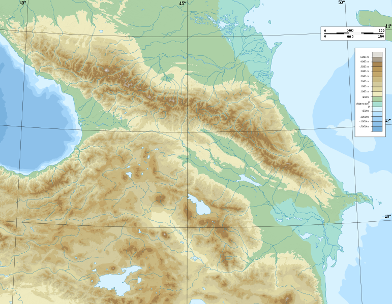
Deutsch: Topographische Karte von Kaukasien, französische Version English: Topographic map in French of Caucasus Français : Carte topographique en français du Caucase |
| 日期 | |
| 來源 |
English: Own work ; Topographic data from the NASA Shuttle Radar Topography Mission (SRTM3 v.2) (public domain) edited with 3DEM, reprojected in UTM with GDAL (GDAL), and vectorized with Inkscape ; UTM projection ; WGS84 datum ; shaded relief (composite image of N-W, W and N lightning positions) ; Reference used for the additional data : * Rivers, bathymetry : Demis add-on for World Wind (see the approval e-mail and the Demis forum) ; * coast : World data bank II ; Approximate scale of topographic data : 1:1,463,000 ; Note : The shaded relief is a raster image embedded in the SVG file. Français : Création personnelle ; Données topographiques de la NASA Shuttle Radar Topography Mission (SRTM3 v.2) (domaine public) éditées avec 3DEM, reprojetées en UTM avec GDAL et vectorisées avec Inkscape ; projection UTM ; WGS84 datum ; relief ombré (image composite d'éclairages du N-O, O et N) ; Références utilisées pour les données complémentaires : * Rivières, bathymétrie : Demis add-on for World Wind (cf. l'e-mail d'approbation de Demis et le Demis forum) ; * côtes : World data bank II ; Échelle approximative des données topographiques : 1:1 463 000 ; Note : Le relief ombré est une image bitmap embarquée dans le fichier SVG. Approximate geographic limits of the map (3' close) : * SW corner : 38°05'00"N – 39°33'00"E * SE corner : 38°05'00"N – 51°00'00"E * NE corner : 45°00'00"N – 51°00'00"E * NW corner : 45°00'00"N – 39°00'00"E |
| 作者 | Bourrichon - fr:Bourrichon) |
| 授權許可 (重用此檔案) |
GFDL / Attribution and Share-Alike required |
| 其他版本 |
|


|
This SVG file contains embedded text that can be translated into your language, using any capable SVG editor, text editor or the SVG Translate tool. For more information see: About translating SVG files. |
授權條款
[編輯]
我,本作品的著作權持有者,決定用以下授權條款發佈本作品:

|
已授權您依據自由軟體基金會發行的無固定段落、封面文字和封底文字GNU自由文件授權條款1.2版或任意後續版本,對本檔進行複製、傳播和/或修改。該協議的副本列在GNU自由文件授權條款中。 |
您可以選擇您需要的授權條款。
檔案歷史
點選日期/時間以檢視該時間的檔案版本。
| 日期/時間 | 縮圖 | 尺寸 | 用戶 | 備註 | |
|---|---|---|---|---|---|
| 目前 | 2008年11月9日 (日) 17:16 | | 1,155 × 898(4.43 MB) | Bourrichon(對話 | 貢獻) | |
| 2008年11月8日 (六) 15:59 |  | 1,155 × 898(4.43 MB) | Bourrichon(對話 | 貢獻) | == Summary == {{Information |Description={{de|Topographische Karte von Kaukasien, französische Version}}{{en|Topographic map in French of Caucasus}}{{fr|Carte topographique en français du Caucase}} |Sou |
無法覆蓋此檔案。
檔案用途
下列26個頁面有用到此檔案:
- File:Azerbaijan topographic map-fr.svg
- File:Azerbaijan topographic map-it.svg
- File:Azerbaijan topographic map-lt.svg
- File:Azerbaijan topographic map-mk.svg
- File:Caucasus by night.svg
- File:Caucasus hydro map-fr.svg
- File:Caucasus mountain range map-fr.svg
- File:Caucasus topo map-blank.jpg
- File:Caucasus topo map-blank.svg
- File:Caucasus topographic map-ar.png
- File:Caucasus topographic map-av.png
- File:Caucasus topographic map-fr.png
- File:Caucasus topographic map-fr.svg
- File:Caucasus topographic map-ru.svg
- File:Chechnya topographic map-fr.svg
- File:Dagestan topographic map-ar.png
- File:Dagestan topographic map-ce.svg
- File:Dagestan topographic map-fr.svg
- File:Dagestan topographic map-lt.svg
- File:Dagestan topographic map-ru.svg
- File:Georgia administrative map-fr.svg
- File:Georgia topographic map-fr.svg
- File:North Caucasus topographic map-es.svg
- File:North Caucasus topographic map-fr.svg
- Category:Caucasus mountains
- Category:Sochi National Park
全域檔案使用狀況
以下其他 wiki 使用了這個檔案:
- ar.wikipedia.org 的使用狀況
- ast.wikipedia.org 的使用狀況
- av.wikipedia.org 的使用狀況
- az.wikipedia.org 的使用狀況
- Azərbaycan dili
- Muğan düzü
- Araz
- Böyük Qafqaz
- Kür
- Göygöl (göl)
- Bazardüzü
- Şablon:Çay
- Ağrı dağı
- Qarayazı Dövlət Təbiət Qoruğu
- Göygöl Dövlət Təbiət Qoruğu
- İlisu Dövlət Təbiət Qoruğu
- Mingəçevir su anbarı
- Hacıqabul gölü
- Türyançay Dövlət Təbiət Qoruğu
- Talış dağları
- Kürəkçay
- Qabırrıçay
- Qanıxçay
- Sumqayıtçay
- İlandağ
- Göyçə gölü
- Göyəzən dağı
- Şablon:Yer xəritəsi
- Şablon:Yer xəritəsi/doc
- Şablon:Yer xəritəsi+
- Xınalıq dağı
- Qafqaz dağları
- Murovdağ
- Kəpəz dağı
- Sarısu gölü
- Böyükşor gölü
- Maralgöl
- Şablon:Su anbarı
- Şablon:Su anbarı/doc
- Candargöl
- Kazbek dağı
- Şirvan düzü
- Mil düzü
- Batabat gölü
- Beşbarmaq dağı
- Babazənən yüksəkliyi
檢視此檔案的更多全域使用狀況。