File:Cedid Atlas (Middle East) 1803.jpg
Mine navigeerimisribale
Mine otsikasti

Selle eelvaate suurus: 793 × 600 pikslit. Teised eraldusvõimed: 317 × 240 pikslit | 635 × 480 pikslit | 1016 × 768 pikslit | 1280 × 968 pikslit | 2560 × 1936 pikslit | 10 840 × 8199 pikslit.
Algfail (10 840 × 8199 pikslit, faili suurus: 18,62 MB, MIME tüüp: image/jpeg)
Pealdised
Pealdised
Lisa üherealine seletus sellest, mida fail esitab
Lühikirjeldus
[muuda]| Warning | The original file is very high-resolution. It might not load properly or could cause your browser to freeze when opened at full size. |
|---|
| Kirjeldus |
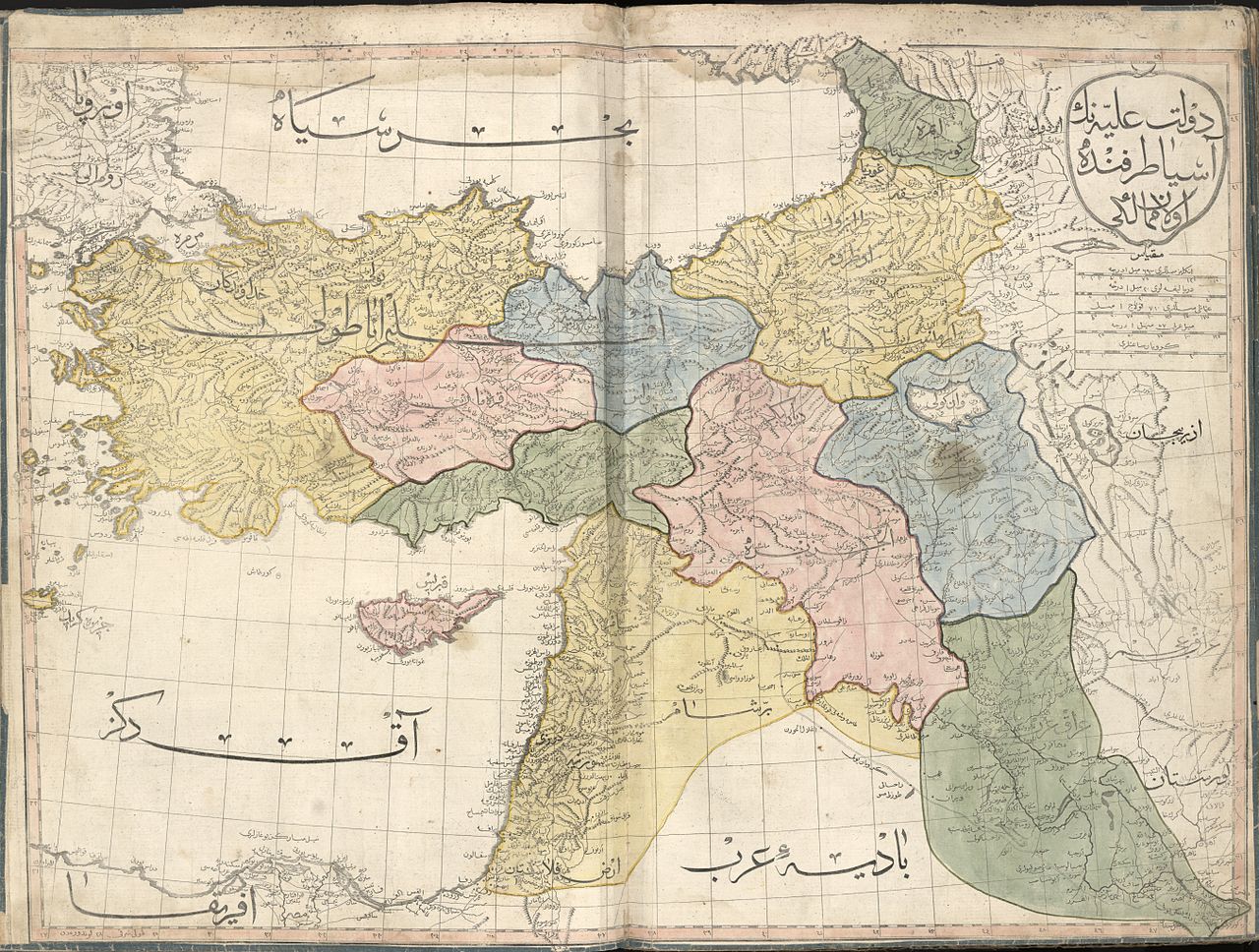
العربية: خارطة عُثمانيَّة تُظهر الإيالات الشرقيَّة لِلدولة العُثمانيَّة سنة 1803م. الخارطة مأخوذة من الأطلس الجديد (وهي واحدة من أصل 24 ورقة). هذا الأطلس هو أوَّل أطلسٍ جُغرافي يُطبع في العالم الإسلامي، ولم يُطبع منه سوى 50 نسخة، وبهذا فهو يُعتبر أحد أندر الأطالس الجُغرافيَّة ذات القيمة التاريخيَّة على المُستويين العالمي والشرق أوسطي.
English: The Middle East sheet of the 1803 Cedid Atlas (one of 24 sheets in total). It is the first published atlas in the Muslim world, and only 50 copies were printed at the press, as such it is one of the rarest printed atlases of historical value and of great importance to Middle Eastern history. |
||
| Kuupäev | |||
| Allikas |
|
||
| Looja |
Ottoman Empire |
||
| Georeferencing | If inappropriate please set warp_status = skip to hide. | ||
| Teised versioonid |

_1803.jpg)

_1803.jpg&action=edit§ion=1)
_1803.jpg&flash=no)
|
_1803.jpg)
_1803.jpg)
Litsents
[muuda]_1803.jpg&action=edit§ion=2)
See teos on Ameerika Ühendriikides avalikus omandis. See käib Ameerika Ühendriikide teoste kohta, mille autoriõigus on aegunud. Põhjuseks võib olla teose avaldamine enne 1. jaanuari 1929. aastal. Täpsema teabe leiad sellelt leheküljelt.
|
 | |
 |
Väljaspool Ameerika Ühendriike ei pruugi see pilt avalikus omandis olla (eriti riikides, nagu Hiina (välja arvatud Hongkong ja Aomen), Kanada, Mehhiko, Saksamaa ja Šveits, kus Ameerika Ühendriikide teostele ei kohaldu lühem autoriõiguse kehtivus). Autor ja avaldamisaasta peavad pildi juures märgitud olema. Täiendava teabe jaoks vaata lehekülgi Wikipedia:Public domain ja Wikipedia:Copyrights.
|
Faili ajalugu
Klõpsa kuupäeva ja kellaaega, et näha sel ajahetkel kasutusel olnud failiversiooni.
| Kuupäev/kellaaeg | Pisipilt | Mõõtmed | Kasutaja | Kommentaar | |
|---|---|---|---|---|---|
| viimane | 9. mai 2015, kell 18:35 | | 10 840 × 8199 (18,62 MB) | Onceinawhile (arutelu | kaastöö) | User created page with UploadWizard |
Sa ei saa seda faili üle kirjutada.
Faili kasutus
Seda faili kasutavad järgmised 17 lehekülge:
- Atlas of the Levant
- User:Fæ/LOC maps/wikimedia usage
- User talk:Onceinawhile
- Commons:Featured picture candidates/File:Cedid Atlas (Middle East) 1803.jpg
- Commons:Featured picture candidates/Log/May 2015
- Commons:Featured pictures/Non-photographic media/Maps
- Commons:Featured pictures/chronological/2015-A
- Commons:Picture of the Year/2015/Candidates
- Commons:Picture of the Year/2015/R1/Gallery/2015-A
- Commons:Picture of the Year/2015/R1/Gallery/ALL
- Commons:Picture of the Year/2015/R1/Gallery/M05
- Commons:Picture of the Year/2015/R1/Gallery/Maps
- Commons:Picture of the Year/2015/R1/Results/Top (non strict)
- Commons:Picture of the Year/2015/R1/v/Cedid Atlas (Middle East) 1803.jpg
- File:Cartouche in an Ottoman map of Cedid Atlas.jpg
- File:Cedid Atlas (Kurdistan) 1803.jpg
- File:Cedid Atlas (Syria) 1803.jpg
_1803.jpg)
_1803.jpg)
Globaalne failikasutus
Järgmised muud vikid kasutavad seda faili:
- Faili kasutus vikis ar.wikipedia.org
- العراق
- تاريخ العراق
- المسيحية في سوريا
- العراق العثماني
- بوابة:الدولة العثمانية
- بوابة:الدولة العثمانية/مقالة مختارة
- بوابة:الدولة العثمانية/صورة
- ويكيبيديا:صور مختارة/رسومات وجداول وخرائط/خرائط
- كردستان العراق
- ويكيبيديا:ترشيحات الصور المختارة/الإيالات العثمانية الشرقية
- ويكيبيديا:صورة اليوم المختارة/فبراير 2017
- قالب:صورة اليوم المختارة/2017-02-01
- بوابة:الدولة العثمانية/صورة مختارة/28
- قائمة إيالات الدولة العثمانية
- ويكيبيديا:قائمة اليوم المختارة/أغسطس 2017
- قالب:قائمة اليوم المختارة/2017-08-14
- بوابة:الدولة العثمانية/مقالة مختارة/36
- ويكيبيديا:قائمة اليوم المختارة/نوفمبر 2017
- قالب:قائمة اليوم المختارة/2017-11-18
- ويكيبيديا:قائمة اليوم المختارة/يناير 2018
- قالب:قائمة اليوم المختارة/2018-01-13
- ويكيبيديا:قائمة اليوم المختارة/يونيو 2018
- قالب:قائمة اليوم المختارة/2018-06-10
- ويكيبيديا:قائمة اليوم المختارة/أغسطس 2018
- قالب:قائمة اليوم المختارة/2018-08-04
- ويكيبيديا:قائمة اليوم المختارة/يناير 2019
- قالب:قائمة اليوم المختارة/2019-01-11
- ويكيبيديا:قائمة اليوم المختارة/يوليو 2019
- قالب:قائمة اليوم المختارة/2019-07-06
- ويكيبيديا:قائمة اليوم المختارة/ديسمبر 2019
- قالب:قائمة اليوم المختارة/2019-12-24
- ويكيبيديا:قائمة اليوم المختارة/يونيو 2020
- قالب:قائمة اليوم المختارة/2020-06-21
- ويكيبيديا:قائمة اليوم المختارة/سبتمبر 2020
- قالب:قائمة اليوم المختارة/2020-09-21
- ويكيبيديا:قائمة اليوم المختارة/أبريل 2021
- قالب:قائمة اليوم المختارة/2021-04-15
- ويكيبيديا:قائمة اليوم المختارة/أكتوبر 2021
- قالب:قائمة اليوم المختارة/2021-10-31
- ويكيبيديا:قائمة اليوم المختارة/يونيو 2022
- قالب:قائمة اليوم المختارة/2022-06-13
- ويكيبيديا:قائمة اليوم المختارة/يناير 2023
- قالب:قائمة اليوم المختارة/2023-01-31
- خرائط فلسطين
- ويكيبيديا:صورة اليوم المختارة/يوليو 2023
- قالب:صورة اليوم المختارة/2023-07-30
- ويكيبيديا:قائمة اليوم المختارة/سبتمبر 2023
- قالب:قائمة اليوم المختارة/2023-09-24
- قالب:قائمة اليوم المختارة/2024-05-18
- Faili kasutus vikis arz.wikipedia.org
Vaata selle faili globaalset kasutust.
_1803.jpg)
_1803.jpg&oldid=852130920)