File:Celtic Sea and Bay of Biscay bathymetric map-en.svg
Pāriet uz navigāciju
Pāriet uz meklēšanu

Size of this PNG preview of this SVG file: 548 × 599 pikseļi. Citi izmēri: 219 × 240 pikseļi | 439 × 480 pikseļi | 702 × 768 pikseļi | 936 × 1 024 pikseļi | 1 872 × 2 048 pikseļi | 3 479 × 3 805 pikseļi.
Sākotnējais fails (SVG fails, definētais izmērs 3 479 × 3 805 pikseļi, faila izmērs: 4,93 MB)
Captions
Captions
Pievieno vienas rindiņas aprakstu, ko šis fails attēlo
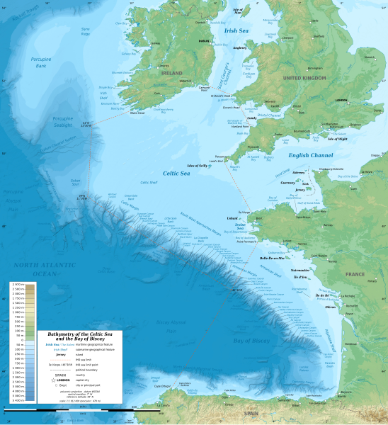
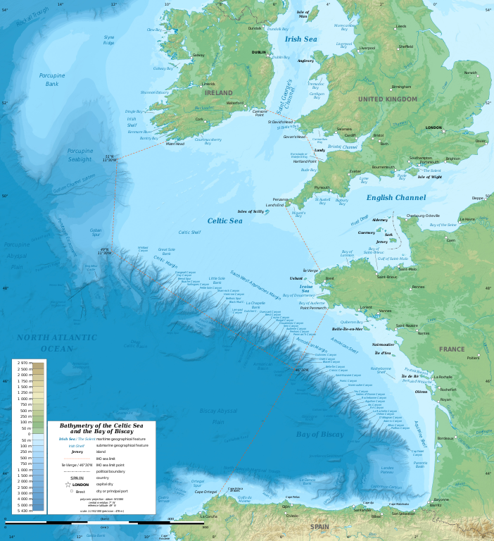
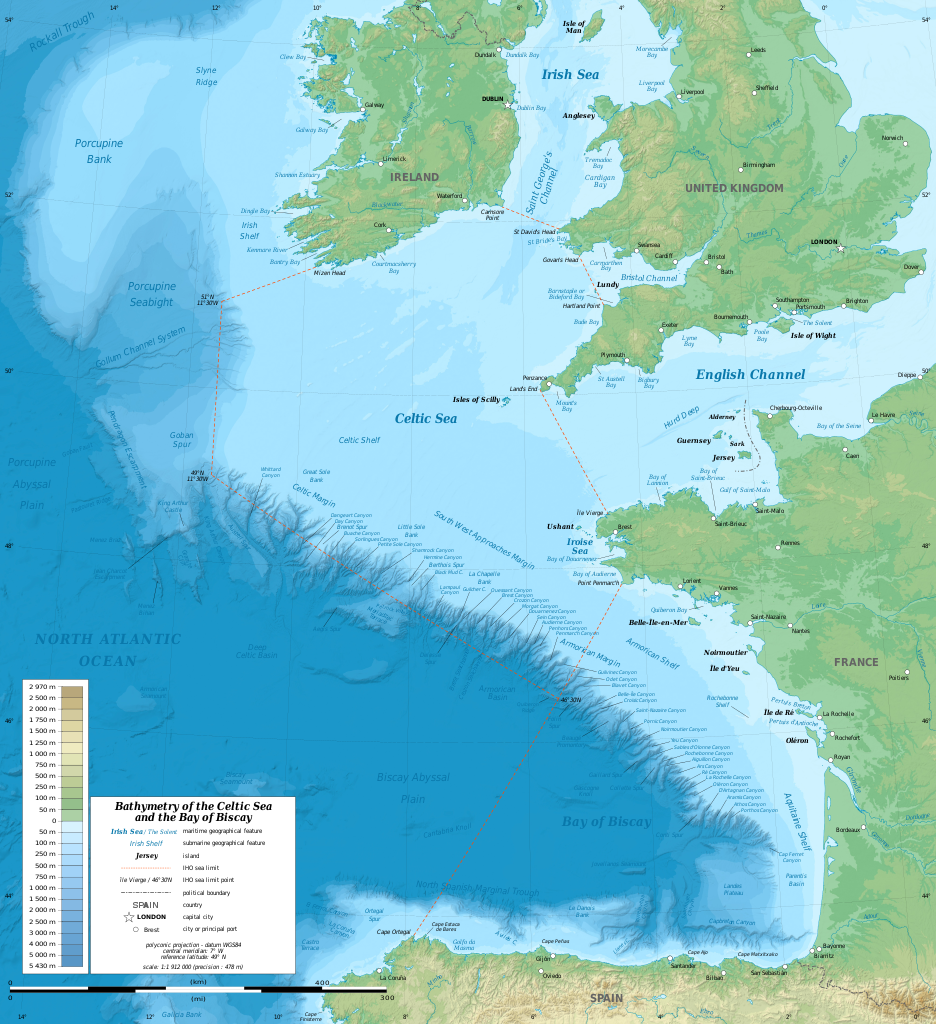
Bathymetric map of the Celtic Sea
Kopsavilkums[labot šo sadaļu]
| Apraksts |
English: Bathymetric map in English of the Celtic Sea and the Bay of Biscay. Limits of the seas as specified by the International Hydrographic Organization.
Note: the background map is a raster image embedded in the SVG file. Français : Carte bathymétrique en anglais de la Mer Celtique et du Golfe de Gascogne. Limites des mers telles que définies par l'Organisation Hydrographique Internationale. Note : le fond de carte est une image bitmap embarquée dans le fichier SVG. |
| Datums | 13:37:01, upgraded 2019-10 |
| Avots | see Celtic Sea and Bay of Biscay bathymetric map-fr.svg |
| Autors | Eric Gaba (Sting - fr:Sting) |
| Citas versijas |
[]
|
| SVG veidošana |


| Camera location | | View this and other nearby images on: OpenStreetMap |
|---|
Licence[labot šo sadaļu]
Šis fails tiek izplatīts saskaņā ar licences Creative Commons Atsauce-Līdzīgi Noteikumi 3.0 Vispārējiem noteikumiem.
- Jūs varat brīvi:
- koplietot – kopēt, izplatīt un pārraidīt darbu
- remiksēt – pielāgot darbu
- Saskaņā ar šādiem nosacījumiem:
- atsaucoties – Tev ir jānorāda autors, saite uz licenci un to, vai veiktas kādas izmaiņas. To var darīt jebkādā saprātīgā veidā, bet ne tādā, kas norādītu, ka licencētājs atbalsta tevi vai veidu, kā tu izmanto šo darbu.
- nemainot licenci – Ja tu miksē, pārveido vai izmanto materiālu, tev savs devums jāpublicē ar to pašu vai saderīgu licenci kā oriģināls.
Faila hronoloģija
Uzklikšķini uz datums/laiks kolonnā esošās saites, lai apskatītos, kā šis fails izskatījās tad.
| Datums/Laiks | Attēls | Izmēri | Dalībnieks | Komentārs | |
|---|---|---|---|---|---|
| tagadējais | 2019. gada 28. oktobris, plkst. 21.33 | | 3 479 × 3 805 (4,93 MB) | Sting (diskusija | devums) | New map using GEBCO 15 Sec topographic data ; rivers from ECRINS ; added names |
| 2014. gada 3. jūlijs, plkst. 14.34 |  | 1 749 × 1 913 (673 KB) | Erigena (diskusija | devums) | minor tweaks | |
| 2014. gada 1. jūlijs, plkst. 12.46 |  | 1 749 × 1 913 (614 KB) | Erigena (diskusija | devums) | User created page with UploadWizard |
Šo failu nevar pārrakstīt.
Faila lietojums
Šo failu izmanto šajās 10 lapās:
- Golfe de Gascogne
- File:Batimetriezh ar Mor Keltiek ha Pleg-mor Gwaskogn.svg
- File:Celtic Sea and Bay of Biscay bathymetric map-en.svg
- File:Celtic Sea and Bay of Biscay bathymetric map-es.svg
- File:Celtic Sea and Bay of Biscay bathymetric map-fr.svg
- File:Celtic Sea and Bay of Biscay bathymetric map-mk.svg
- File:Galicia & Galicia Bank-en.svg
- Template:Other versions/Celtic Sea and Bay of Biscay bathymetric map
- Category:Bay of Biscay
- Category:Tributaries of the Bay of Biscay
Globālais faila lietojums
Šīs Vikipēdijas izmanto šo failu:
- Izmantojums af.wikipedia.org
- Izmantojums azb.wikipedia.org
- Izmantojums bg.wikipedia.org
- Izmantojums bh.wikipedia.org
- Izmantojums bn.wikipedia.org
- Izmantojums cs.wikipedia.org
- Izmantojums de.wikipedia.org
- Izmantojums en.wikipedia.org
- Izmantojums en.wikiversity.org
- Izmantojums fa.wikipedia.org
- Izmantojums fi.wikipedia.org
- Izmantojums frr.wikipedia.org
- Izmantojums fy.wikipedia.org
- Izmantojums gl.wikipedia.org
- Izmantojums hu.wikipedia.org
- Izmantojums hy.wikipedia.org
- Izmantojums hyw.wikipedia.org
- Izmantojums id.wikipedia.org
- Izmantojums ja.wikipedia.org
- Izmantojums lo.wikipedia.org
- Izmantojums lv.wikipedia.org
- Izmantojums nl.wikipedia.org
- Izmantojums ru.wikipedia.org
- Izmantojums sq.wikipedia.org
- Izmantojums sr.wikipedia.org
- Izmantojums sv.wikipedia.org
- Izmantojums tg.wikipedia.org
- Izmantojums th.wikipedia.org
- Izmantojums tr.wikipedia.org
- Izmantojums uk.wikipedia.org
- Izmantojums vi.wikipedia.org
- Izmantojums vls.wikipedia.org
- Izmantojums www.wikidata.org
- Izmantojums zh-min-nan.wikipedia.org
- Izmantojums zh-yue.wikipedia.org
- Izmantojums zh.wikipedia.org