File:Celtic Sea and Bay of Biscay bathymetric map-en.svg
跳至導覽
跳至搜尋

此 SVG 檔案的 PNG 預覽的大小:548 × 599 像素。 其他解析度:219 × 240 像素 | 439 × 480 像素 | 702 × 768 像素 | 936 × 1,024 像素 | 1,872 × 2,048 像素 | 3,479 × 3,805 像素。
原始檔案 (SVG 檔案,表面大小:3,479 × 3,805 像素,檔案大小:4.93 MB)
說明
說明
添加單行說明來描述出檔案所代表的內容
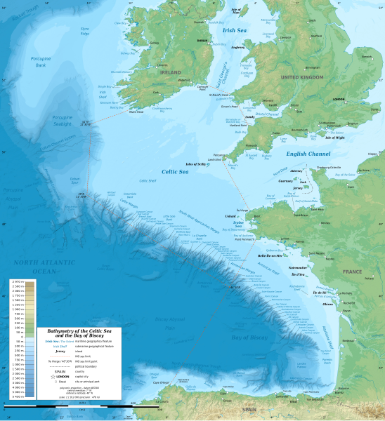
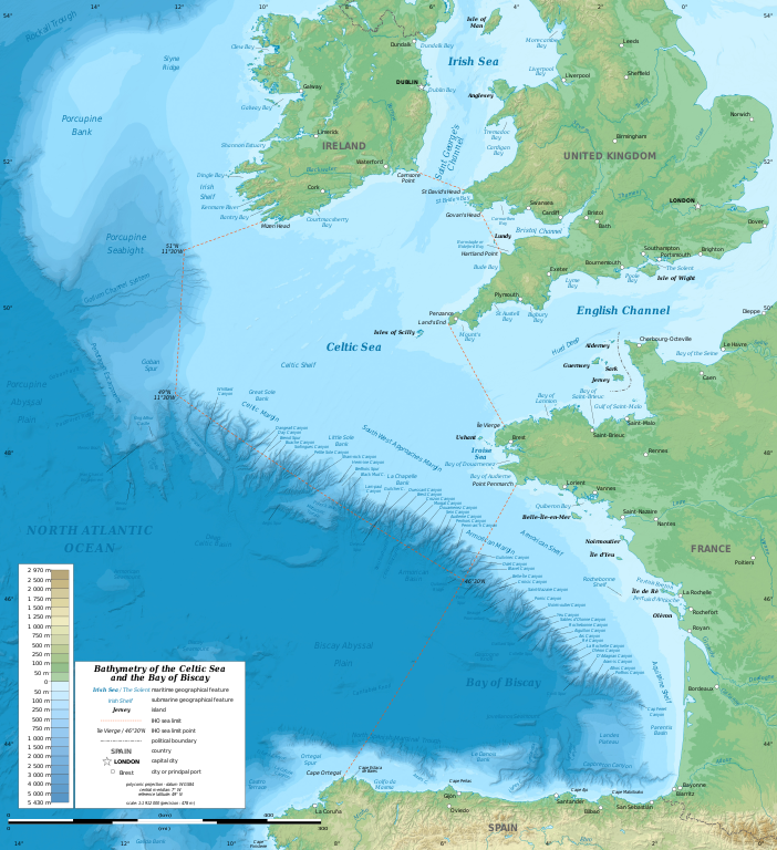
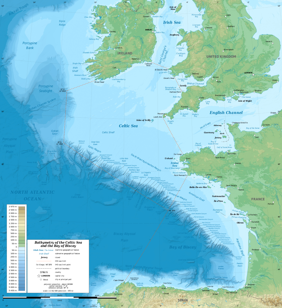
Bathymetric map of the Celtic Sea
摘要
[編輯]| 描述 |
English: Bathymetric map in English of the Celtic Sea and the Bay of Biscay. Limits of the seas as specified by the International Hydrographic Organization.
Note: the background map is a raster image embedded in the SVG file. Français : Carte bathymétrique en anglais de la Mer Celtique et du Golfe de Gascogne. Limites des mers telles que définies par l'Organisation Hydrographique Internationale. Note : le fond de carte est une image bitmap embarquée dans le fichier SVG. |
| 日期 | 13:37:01, upgraded 2019-10 |
| 來源 | see Celtic Sea and Bay of Biscay bathymetric map-fr.svg |
| 作者 | Eric Gaba (Sting - fr:Sting) |
| 其他版本 |
[]
|
| SVG開發 | 這個SVG 檔案使用了內置文字,可以使用任何文字編輯器輕鬆翻譯。 |


| 拍攝地點 | | 位於此地的本圖片與其他圖片: OpenStreetMap |
|---|
授權條款
[編輯]
此檔案採用創用CC 姓名標示-相同方式分享 3.0 未在地化版本授權條款。
- 您可以自由:
- 分享 – 複製、發佈和傳播本作品
- 重新修改 – 創作演繹作品
- 惟需遵照下列條件:
- 姓名標示 – 您必須指名出正確的製作者,和提供授權條款的連結,以及表示是否有對內容上做出變更。您可以用任何合理的方式來行動,但不得以任何方式表明授權條款是對您許可或是由您所使用。
- 相同方式分享 – 如果您利用本素材進行再混合、轉換或創作,您必須基於如同原先的相同或兼容的條款,來分布您的貢獻成品。
檔案歷史
點選日期/時間以檢視該時間的檔案版本。
| 日期/時間 | 縮圖 | 尺寸 | 使用者 | 備註 | |
|---|---|---|---|---|---|
| 目前 | 2019年10月28日 (一) 21:33 | | 3,479 × 3,805(4.93 MB) | Sting(留言 | 貢獻) | New map using GEBCO 15 Sec topographic data ; rivers from ECRINS ; added names |
| 2014年7月3日 (四) 14:34 |  | 1,749 × 1,913(673 KB) | Erigena(留言 | 貢獻) | minor tweaks | |
| 2014年7月1日 (二) 12:46 |  | 1,749 × 1,913(614 KB) | Erigena(留言 | 貢獻) | User created page with UploadWizard |
無法覆蓋此檔案。
檔案用途
下列10個頁面有用到此檔案:
- Golfe de Gascogne
- File:Batimetriezh ar Mor Keltiek ha Pleg-mor Gwaskogn.svg
- File:Celtic Sea and Bay of Biscay bathymetric map-en.svg
- File:Celtic Sea and Bay of Biscay bathymetric map-es.svg
- File:Celtic Sea and Bay of Biscay bathymetric map-fr.svg
- File:Celtic Sea and Bay of Biscay bathymetric map-mk.svg
- File:Galicia & Galicia Bank-en.svg
- Template:Other versions/Celtic Sea and Bay of Biscay bathymetric map
- Category:Bay of Biscay
- Category:Tributaries of the Bay of Biscay
全域檔案使用狀況
以下其他 wiki 使用了這個檔案:
- af.wikipedia.org 的使用狀況
- azb.wikipedia.org 的使用狀況
- bg.wikipedia.org 的使用狀況
- bh.wikipedia.org 的使用狀況
- bn.wikipedia.org 的使用狀況
- cs.wikipedia.org 的使用狀況
- de.wikipedia.org 的使用狀況
- en.wikipedia.org 的使用狀況
- en.wikiversity.org 的使用狀況
- fa.wikipedia.org 的使用狀況
- fi.wikipedia.org 的使用狀況
- frr.wikipedia.org 的使用狀況
- fy.wikipedia.org 的使用狀況
- gl.wikipedia.org 的使用狀況
- hu.wikipedia.org 的使用狀況
- hy.wikipedia.org 的使用狀況
- hyw.wikipedia.org 的使用狀況
- id.wikipedia.org 的使用狀況
- ja.wikipedia.org 的使用狀況
- lo.wikipedia.org 的使用狀況
- lv.wikipedia.org 的使用狀況
- nl.wikipedia.org 的使用狀況
- ru.wikipedia.org 的使用狀況
- sq.wikipedia.org 的使用狀況
- sr.wikipedia.org 的使用狀況
- sv.wikipedia.org 的使用狀況
- tg.wikipedia.org 的使用狀況
- th.wikipedia.org 的使用狀況
- tr.wikipedia.org 的使用狀況
- uk.wikipedia.org 的使用狀況
- vi.wikipedia.org 的使用狀況
- vls.wikipedia.org 的使用狀況
- www.wikidata.org 的使用狀況
- zh-min-nan.wikipedia.org 的使用狀況
- zh-yue.wikipedia.org 的使用狀況
- zh.wikipedia.org 的使用狀況