File:Central African Republic sub-prefectures.png
ナビゲーションに移動
検索に移動

このプレビューのサイズ: 800 × 486 ピクセル。 その他の解像度: 320 × 194 ピクセル | 640 × 389 ピクセル | 1,025 × 623 ピクセル。
元のファイル (1,025 × 623 ピクセル、ファイルサイズ: 19キロバイト、MIME タイプ: image/png)
キャプション
キャプション
このファイルの内容を1行で記述してください

|
This map has been uploaded by Electionworld from en.wikipedia.org to enable the |
概要
[編集]
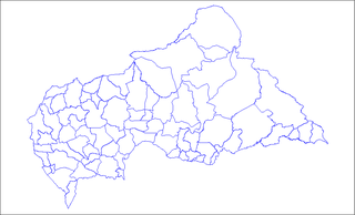
Map of the sub-prefectures of the Central African Republic. Created by Rarelibra 17:58, 31 March 2006 (UTC) for public domain use. Created using MapInfo Professional v7.5 and various mapping resources.
ライセンス
[編集]
| この著作物の著作権者である私は、この著作物における権利を放棄しパブリックドメインとします。これは全世界で適用されます。 一部の国では、これが法的に可能ではない場合があります。その場合は、次のように宣言します。 私は、あらゆる人に対して、法により必要とされている条件を除き、如何なる条件も課すことなく、あらゆる目的のためにこの著作物を使用する権利を与えます。 |
ファイルの履歴
過去の版のファイルを表示するには、その版の日時をクリックしてください。
| 日付と時刻 | サムネイル | 寸法 | 利用者 | コメント | |
|---|---|---|---|---|---|
| 現在の版 | 2022年6月3日 (金) 09:36 | | 1,025 × 623 (19キロバイト) | Borysk5 (トーク | 投稿記録) | Blue color |
| 2022年6月2日 (木) 17:39 |  | 1,025 × 624 (20キロバイト) | Borysk5 (トーク | 投稿記録) | Updated map | |
| 2006年11月27日 (月) 19:19 |  | 1,025 × 624 (18キロバイト) | Electionworld (トーク | 投稿記録) | {{ew|en|Rarelibra}} == Summary == Map of the sub-prefectures of the Central African Republic. Created by Rarelibra 17:58, 31 March 2006 (UTC) for public domain use. Created using MapInfo Professional v7.5 and various mapping resources. |
このファイルは上書きできません。
ファイルの使用状況
以下のページがこのファイルを使用しています:
グローバルなファイル使用状況
以下に挙げる他のウィキがこの画像を使っています:
- ca.wikipedia.org での使用状況
- cs.wikipedia.org での使用状況
- en.wikipedia.org での使用状況
- Bangui
- Mobaye
- Bria, Central African Republic
- Obo
- Sibut
- Mbaïki
- Bambari
- Kaga-Bandoro
- Bangassou
- Bouar
- Berbérati
- N'Délé
- Kabo
- Alindao
- Batangafo
- Baoro
- Birao
- Boali
- Bossangoa
- Bozoum
- Boda, Lobaye
- Bouca
- Damara, Central African Republic
- Carnot, Central African Republic
- Nola, Central African Republic
- Rafaï
- Mongoumba
- Ouadda
- Ippy
- Kouango
- Kembé
- Paoua
- Gamboula
- Sub-prefectures of the Central African Republic
- User talk:Rarelibra/Maps2
- Bakouma
- Bocaranga
- Ouanda Djallé
- Grimari
- Baboua, Central African Republic
- Bamingui
- Yalinga
- Zemio
- Djemah
- Template:Sub-prefectures of the Central African Republic
- Mingala
- Dekoa
- Gambo-Ouango
このファイルのグローバル使用状況を表示する。