File:Central and Eastern Europe at the time of Augustus 6 AD.jpg
Μετάβαση στην πλοήγηση
Πήδηση στην αναζήτηση

Μέγεθος αυτής της προεπισκόπησης: 800 × 584 εικονοστοιχεία . Άλλες αναλύσεις: 320 × 234 εικονοστοιχεία | 640 × 467 εικονοστοιχεία | 1.024 × 748 εικονοστοιχεία | 1.280 × 935 εικονοστοιχεία | 2.600 × 1.899 εικονοστοιχεία.
Πρωτότυπο αρχείο (2.600 × 1.899 εικονοστοιχεία, μέγεθος αρχείου: 740 KB, τύπος MIME: image/jpeg)
Λεζάντες
Λεζάντες
Δεν ορίστηκε λεζάντα
Σύνοψη[επεξεργασία]
| Περιγραφή | |
| Ημερομηνία | |
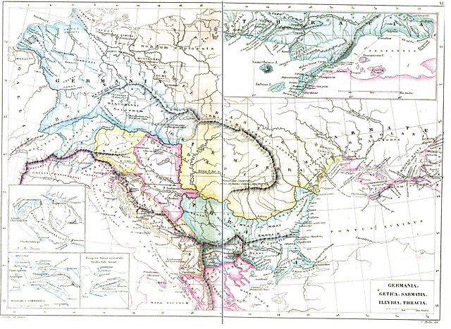
| Πηγή | Strabonis Geographicorum tabulae XV 1877, pp: 1088-1089 by Strabo, Karl Wilhelm Ludwig Müller, editor Ambrosio Firmin-Didot. |
| Δημιουργός | Karl Wilhelm Ludwig Müller (Carolus Mullerus) (1813–1894) |
Αδειοδότηση[επεξεργασία]
|
Αυτό το έργο είναι κοινό κτήμα στη χώρα προέλευσής του και άλλες χώρες και περιοχές όπου η διάρκεια πνευματικών δικαιωμάτων είναι όσο η ζωή του δημιουργού και μέχρι 100 χρόνια μετά ή λιγότερο. | |
| Αυτό το αρχείο έχει χαρακτηριστεί ως απαλλαγμένο από γνωστούς περιορισμούς βάσει της νομοθεσίας περί πνευματικής ιδιοκτησίας, περιλαμβανομένων όλων των συναφών και συγγενικών δικαιωμάτων. | |
Ιστορικό αρχείου
Πατήστε σε μια ημερομηνία/ώρα για να δείτε το αρχείο όπως εμφανιζόταν εκείνη την χρονική στιγμή.
| Ημερομηνία/Ώρα | Μικρογραφία | Διαστάσεις | Χρήστης | Σχόλιο | |
|---|---|---|---|---|---|
| τρέχον | 05:11, 26 Απριλίου 2011 | | 2.600 × 1.899 (740 KB) | Boldwin (συζήτηση | Συνεισφορά) | {{Information |Description ={{en|1=Map of Getica (Daci Terra Getarum) Germania, Sarmatia, Illyria, Thracia according to Strabo (ca.18 AD). The map is from the book "Strabonis Geographicorum tabulae XV" by Strabo of the author = German scholar Karl |
Δεν μπορείτε να αντικαταστήσετε αυτό το αρχείο.
Χρήση αρχείου
Οι ακόλουθες 6 σελίδες χρησιμοποιούν προς αυτό το αρχείο:
- Illyria and Illyrians
- User:Boldwin
- File:Central and Eastern Europe before 218 BC.jpg (ανακατεύθυνση του αρχείου)
- File:Daci Terra Getarum cf Strabo.JPG (ανακατεύθυνση του αρχείου)
Καθολική χρήση αρχείου
Τα ακόλουθα άλλα wiki χρησιμοποιούν αυτό το αρχείο:
- Χρήση σε el.wikipedia.org
- Χρήση σε en.wikipedia.org
- Χρήση σε it.wikipedia.org
- Χρήση σε pt.wikipedia.org
- Χρήση σε ro.wikipedia.org
- Χρήση σε ru.wikipedia.org
- Χρήση σε sr.wikipedia.org
- Χρήση σε uz.wikipedia.org
Μεταδεδομένα
Κατηγορίες:
- Dacia
- Roman Germania
- Maps of ancient Thrace
- Maps of Illyria
- Maps of Dacia
- Maps of the history of Germany (before 400)
- Old maps of the Balkans
- Romania in the 3rd century BC
- Maps of the history of Romania in ancient times
- Geographica
- Latin-language maps
- Old maps of Romania
- Maps of the history of the ancient Balkans
- Maps concerning Augustus