File:Centres of origin and spread of agriculture.svg
Salta a la navegació
Salta a la cerca

Mida d'aquesta previsualització PNG del fitxer SVG: 800 × 353 píxels. Altres resolucions: 320 × 141 píxels | 640 × 283 píxels | 1.024 × 452 píxels | 1.280 × 565 píxels | 2.560 × 1.130 píxels | 940 × 415 píxels.
Fitxer original (fitxer SVG, nominalment 940 × 415 píxels, mida del fitxer: 1,62 Mo)
Llegendes
Llegendes
Afegeix una explicació d'una línia del que representa aquest fitxer
Origins of agriculture
Resum
[modifica]
| Descripció |
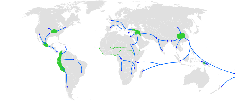
English: Map of the world showing approximate centres of origin of agriculture and its spread in prehistory: eastern USA (4000-3000 BP), Central Mexico (5000-4000 BP), Northern South America (5000-4000 BP), sub-Saharan Africa (5000-4000 BP, exact location unknown), the Fertile Crescent (11000 BP), the Yangtze and Yellow River basins (9000 BP) and the New Guinea Highlands (9000-6000 BP). A proposed centre of origin in Amazonia (Lathrap 1977) is not shown. Adapted from File:BlankMap-World6, compact.svg and Diamond, J. (2003). "Farmers and Their Languages: The First Expansions". Science 300: 597–603. DOI:10.1126/science.1078208. "Fig. 1" |
| Data | |
| Font | Treball propi |
| Autor | Joe Roe |
Derivative works of this file:
- Centres of origin and spread of agriculture v2.svg
- Ursprungszentren und Verbreitung der Landwirtschaft im Zuge der neolithische Revolution.png
Llicència
[modifica]
Jo, el titular dels drets d'autor d'aquest treball, el public sota les següents llicències:
Aquest fitxer està subjecte a la llicència de Creative Commons Reconeixement i Compartir Igual 3.0 No adaptada.
- Sou lliure de:
- compartir – copiar, distribuir i comunicar públicament l'obra
- adaptar – fer-ne obres derivades
- Amb les condicions següents:
- reconeixement – Heu de donar la informació adequada sobre l'autor, proporcionar un enllaç a la llicència i indicar si s'han realitzat canvis. Podeu fer-ho amb qualsevol mitjà raonable, però de cap manera no suggereixi que l'autor us dóna suport o aprova l'ús que en feu.
- compartir igual – Si modifiqueu, transformeu, o generareu amb el material, haureu de distribuir les vostres contribucions sota una llicència similar o una de compatible com l'original

|
S'autoritza la còpia, la distribució i la modificació d'aquest document sota els termes de la llicència de documentació lliure GNU versió 1.2 o qualsevol altra versió posterior que publiqui la Free Software Foundation; sense seccions invariants, ni textos de portada, ni textos de contraportada. S'inclou una còpia d'aquesta llicència en la secció titulada GNU Free Documentation License. |
Podeu seleccionar la llicència que vulgueu.
Historial del fitxer
Cliqueu una data/hora per veure el fitxer tal com era aleshores.
| Data/hora | Miniatura | Dimensions | Usuari/a | Comentari | |
|---|---|---|---|---|---|
| actual | 12:25, 23 maig 2013 | | 940 × 415 (1,62 Mo) | Cmglee (discussió | contribucions) | Make arrows blue to distinguish arrows and regions. |
| 12:35, 29 nov 2010 |  | 940 × 415 (1,67 Mo) | Joey Roe (discussió | contribucions) | {{Information |Description={{en|1=Map of the world showing approximate centres of agriculture and its spread in prehistory: eastern USA (4000-3000 BP), Central Mexico (5000-4000 BP), Northern South America (5000-4000 BP), sub-Saharan Africa (5000-4000 BP, |
No podeu sobreescriure aquest fitxer.
Ús del fitxer
Les 3 pàgines següents utilitzen aquest fitxer:
Ús global del fitxer
Utilització d'aquest fitxer en altres wikis:
- Utilització a af.wikipedia.org
- Utilització a ar.wikipedia.org
- Utilització a ast.wikipedia.org
- Utilització a as.wikipedia.org
- Utilització a az.wikipedia.org
- Utilització a bn.wikipedia.org
- Utilització a ca.wikipedia.org
- Utilització a de.wikipedia.org
- Utilització a en.wikipedia.org
- Utilització a en.wikiquote.org
- Utilització a es.wikipedia.org
- Utilització a es.wikibooks.org
- Utilització a eu.wikipedia.org
- Utilització a fa.wikipedia.org
- Utilització a fi.wikipedia.org
- Utilització a fr.wikipedia.org
Vegeu més usos globals d'aquest fitxer.