File:Ceres Polarmetric Map.jpg
Jump to navigation
Jump to search
Size of this preview: 800 × 538 pixels. Other resolutions: 320 × 215 pixels | 640 × 431 pixels | 1,024 × 689 pixels | 1,280 × 861 pixels.
Original file (1,280 × 861 pixels, file size: 73 KB, MIME type: image/jpeg)
Captions
Captions
Add a one-line explanation of what this file represents
Summary
[edit]
| Description |
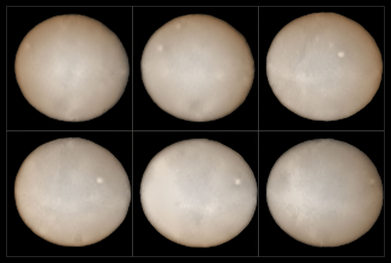
English: These images, taken two weeks apart, show the two hemispheres of Ceres and provide the best ground-based observations of the dwarf planet ever. They were taken using the SPHERE instrument on ESO's Very Large Telescope and form part of an effort undertaken since mid-July 2015 to compose a polarimetric map of the object's surface.
Orbiting in the asteroid belt between Mars and Jupiter, a region known as the asteroid belt, Ceres was the first asteroid to be discovered in 1801 and is the largest belt asteroid. It is the largest reservoir of water in Earth's neighbourhood. Most of this water is thought to exist in the form of water ice in the object's mantle. The surface of the dwarf planet is about the size of India and several intriguing bright spots can be seen in these new images. These mysterious bright patches have also been looked at more closely by NASA's Dawn spacecraft, currently in orbit around Ceres. Astronomers have scrutinised them, but their true nature remains obscure. It is hoped, however, that by comparing the data obtained using SPHERE with the images Dawn is sending to Earth, astronomers should soon be able to begin decoding the Ceres enigma. |
| Date | |
| Source | http://cdn.eso.org/images/screen/potw1536a.jpg |
| Author | ESO, B. Yang and Z. Wahhaj |
Licensing
[edit]
This media was created by the European Southern Observatory (ESO).
Their website states: "Unless specifically noted, the images, videos, and music distributed on the public ESO website, along with the texts of press releases, announcements, pictures of the week, blog posts and captions, are licensed under a Creative Commons Attribution 4.0 International License, and may on a non-exclusive basis be reproduced without fee provided the credit is clear and visible." To the uploader: You must provide a link (URL) to the original file and the authorship information if available. | |
This file is licensed under the Creative Commons Attribution 4.0 International license.
| |
File history
Click on a date/time to view the file as it appeared at that time.
| Date/Time | Thumbnail | Dimensions | User | Comment | |
|---|---|---|---|---|---|
| current | 15:42, 8 September 2015 | | 1,280 × 861 (73 KB) | Nerakogerru (talk | contribs) | User created page with UploadWizard |
You cannot overwrite this file.
File usage on Commons
The following 2 pages use this file:
- File:Potw1536a.jpg (file redirect)
- File:SPHERE Maps the Surface of Ceres (21053077148).jpg (file redirect)
.jpg&redirect=no)
File usage on other wikis
The following other wikis use this file:
- Usage on cs.wikipedia.org
- Usage on fr.wikipedia.org
- Usage on ja.wikipedia.org