File:Cerescompositionmap.jpg
Jump to navigation
Jump to search

Size of this preview: 800 × 400 pixels. Other resolutions: 320 × 160 pixels | 640 × 320 pixels | 1,000 × 500 pixels.
Original file (1,000 × 500 pixels, file size: 246 KB, MIME type: image/jpeg)
Captions
Captions
Add a one-line explanation of what this file represents
Summary[edit]
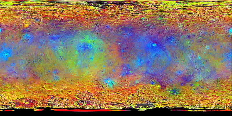
Complete map of the dwarf planet Ceres in false colour. Derived from the first mapping cycle at an altitude of 1,470 km (915 mi). Employs a combination of violet (440 nm) near-infrared (750 nm), and infrared (920 nm) filters.
Source: NASA / JPL-Caltech / UCLA / MPS / DLR / IDA
Licensing[edit]
| This file is in the public domain in the United States because it was solely created by NASA. NASA copyright policy states that "NASA material is not protected by copyright unless noted". (See Template:PD-USGov, NASA copyright policy page or JPL Image Use Policy.) | ||
 |
Warnings:
|
This work is in the public domain in the United States because it is a work prepared by an officer or employee of the United States Government as part of that person’s official duties under the terms of Title 17, Chapter 1, Section 105 of the US Code.
Note: This only applies to original works of the Federal Government and not to the work of any individual U.S. state, territory, commonwealth, county, municipality, or any other subdivision. This template also does not apply to postage stamp designs published by the United States Postal Service since 1978. (See § 313.6(C)(1) of Compendium of U.S. Copyright Office Practices). It also does not apply to certain US coins; see The US Mint Terms of Use.
|
 | |
| This file has been identified as being free of known restrictions under copyright law, including all related and neighboring rights. | ||
File history
Click on a date/time to view the file as it appeared at that time.
| Date/Time | Thumbnail | Dimensions | User | Comment | |
|---|---|---|---|---|---|
| current | 01:37, 21 August 2021 | | 1,000 × 500 (246 KB) | Serendipodous (talk | contribs) | Complete map of the dwarf planet Ceres in false colour. Derived from the first mapping cycle at an altitude of 1,470 km (915 mi). Employs a combination of violet (440 nm) near-infrared (750 nm), and infrared (920 nm) filters. NASA / JPL-Caltech / UCLA / MPS / DLR / IDA =={{int:license-header}}== {{PD-USGov-NASA}} Category:Maps of Ceres Category:Photos of Ceres by Dawn |
You cannot overwrite this file.
File usage on Commons
There are no pages that use this file.