File:Cerro del Plomo route.jpeg

Original file (4,224 × 2,376 pixels, file size: 2.43 MB, MIME type: image/jpeg)
Captions
Captions
Summary
[edit]
| Description |
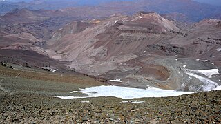
English: Looking south on most of the Cerro del Plomo route.
Somewhat to the left, near the greenish spots deep down in the Estero Cepo valley, is the Piedra Numerada base camp (approx. 3,400m). The route then follows this valley to La Hoya (or La Olla; approx. 4,200m), which is hidden by the moraine at the far right of the picture. From this moraine, the track is clearly visible on the picture, going first to the newly rebuilt Refugio Agostini (the red dot near the center of the picture; 4,620m), and then in steep hairpins (mostly hidden) to the easy traverse at the far left. From here it is less than two hours to the summit, with, immediately beyond the Pirca del Inca burial site, a short glacier crossing. El Pintor (approx. 4,200m) can be seen in the background. The Cerro del Plomo (5,424m) is not to be confused with the Nevado El Plomo (6,070m), which lies on the border about 20km to the north-east. (Cf. John Biggar, The Andes — A Guide for Climbers, ISBN 0-9536087-2-7, p. 217; Hermann Kiendler, Die Anden — Vom Chimborazo zum Marmolejo — Alle 6000er auf einen Blick, ISBN 978-3-936740-36-3, pp. 349–352.) |
| Date | |
| Source | Own work |
| Author | Tijs Michels |
| Permission (Reusing this file) |
cc-by-sa-3.0 (attribution required - see below) |
Licensing
[edit]
- You are free:
- to share – to copy, distribute and transmit the work
- to remix – to adapt the work
- Under the following conditions:
- attribution – You must give appropriate credit, provide a link to the license, and indicate if changes were made. You may do so in any reasonable manner, but not in any way that suggests the licensor endorses you or your use.
- share alike – If you remix, transform, or build upon the material, you must distribute your contributions under the same or compatible license as the original.
File history
Click on a date/time to view the file as it appeared at that time.
| Date/Time | Thumbnail | Dimensions | User | Comment | |
|---|---|---|---|---|---|
| current | 20:20, 21 March 2010 | | 4,224 × 2,376 (2.43 MB) | Tmichels (talk | contribs) | {{Information |Description={{en|1=Looking south on most of the Cerro del Plomo route. Somewhat to the left, near the greenish spots deep down in the Estero Cepo valley, is the Piedra Numerada base camp (approx. 3,400m). The route t |
You cannot overwrite this file.
File usage on Commons
There are no pages that use this file.
File usage on other wikis
The following other wikis use this file:
- Usage on ca.wikipedia.org
- Usage on en.wikipedia.org
- Usage on eo.wikipedia.org
- Usage on es.wikipedia.org
- Usage on ru.wikipedia.org
- Usage on uk.wikipedia.org