File:Château du Nouveau-Windstein.jpg
Original file (3,264 × 2,448 pixels, file size: 7.12 MB, MIME type: image/jpeg)
Captions
Summary[edit]
DescriptionChâteau du Nouveau-Windstein.jpg |
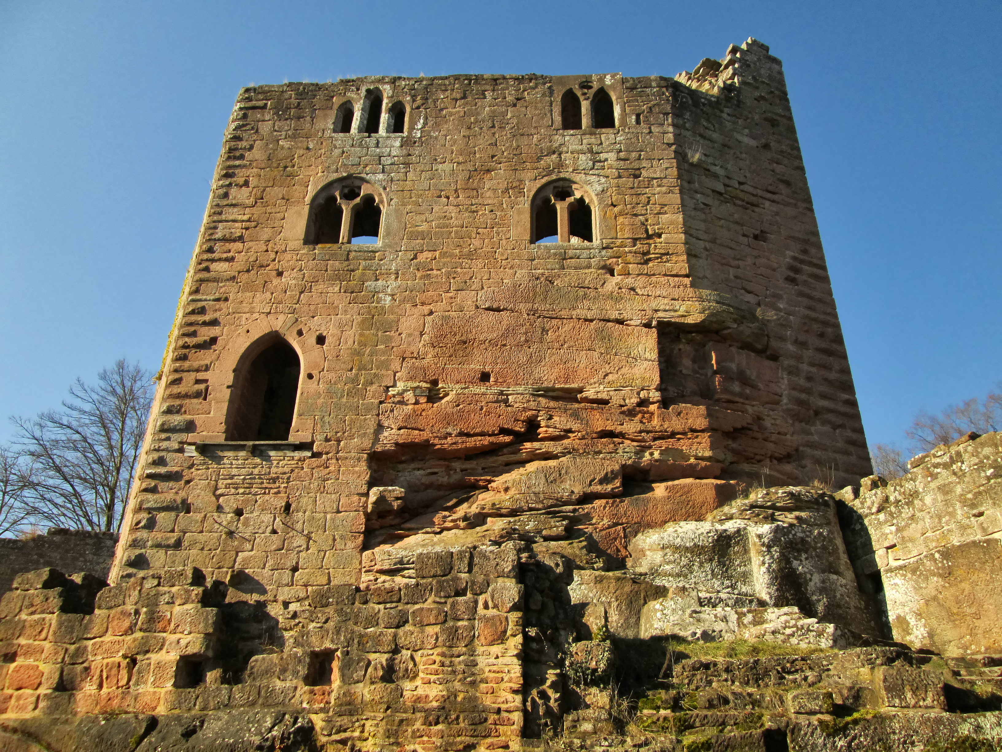
Français : Ruines du château du Nouveau-Windstein, detruit par l'artillerie du général Montclar lors des guerres de Louis XIV.
Deutsch: Ruinen der Burg von New-Windstein, die von der Artillerie von General Montclar während der Kriege von Ludwig XIV. zerstört wurde.
English: Ruins of the castle of New-Windstein, destroyed by General Montclar's artillery during the wars of Louis XIV.
|
|
Date | ||
Source | Own work | |
Author | Pascal Dihé | |
Attribution (required by the license) InfoField | © Pascal Dihé / https://www.dihe.eu / | |
InfoField | © Pascal Dihé / https://www.dihe.eu |
Camera location | 48° 59′ 36.46″ N, 7° 40′ 43.13″ E | View this and other nearby images on: OpenStreetMap | 48.993461; 7.678647 |
---|
Licensing[edit]
- You are free:
- to share – to copy, distribute and transmit the work
- to remix – to adapt the work
- Under the following conditions:
- attribution – You must give appropriate credit, provide a link to the license, and indicate if changes were made. You may do so in any reasonable manner, but not in any way that suggests the licensor endorses you or your use.
- share alike – If you remix, transform, or build upon the material, you must distribute your contributions under the same or compatible license as the original.
This image was uploaded as part of Wiki Loves Monuments 2018.
Afrikaans ∙ Alemannisch ∙ azərbaycanca ∙ Bahasa Indonesia ∙ Bahasa Melayu ∙ Bikol Central ∙ bosanski ∙ brezhoneg ∙ català ∙ čeština ∙ Cymraeg ∙ dansk ∙ davvisámegiella ∙ Deutsch ∙ eesti ∙ English ∙ español ∙ Esperanto ∙ euskara ∙ français ∙ Frysk ∙ Gaeilge ∙ galego ∙ hrvatski ∙ Ido ∙ italiano ∙ latviešu ∙ Lëtzebuergesch ∙ Malagasy ∙ magyar ∙ Malti ∙ Nederlands ∙ norsk ∙ norsk nynorsk ∙ norsk bokmål ∙ polski ∙ português ∙ português do Brasil ∙ română ∙ shqip ∙ sicilianu ∙ slovenčina ∙ slovenščina ∙ suomi ∙ svenska ∙ Tagalog ∙ Türkçe ∙ Yorùbá ∙ Zazaki ∙ Ελληνικά ∙ беларуская ∙ беларуская (тарашкевіца) ∙ български ∙ кыргызча ∙ македонски ∙ русский ∙ српски / srpski ∙ українська ∙ ქართული ∙ հայերեն ∙ नेपाली ∙ हिन्दी ∙ বাংলা ∙ മലയാളം ∙ ไทย ∙ 한국어 ∙ +/− |
File history
Click on a date/time to view the file as it appeared at that time.
Date/Time | Thumbnail | Dimensions | User | Comment | |
---|---|---|---|---|---|
current | 05:23, 30 September 2018 | 3,264 × 2,448 (7.12 MB) | Pascal Dihé (talk | contribs) | User created page with UploadWizard |
You cannot overwrite this file.
File usage on Commons
There are no pages that use this file.
Metadata
This file contains additional information such as Exif metadata which may have been added by the digital camera, scanner, or software program used to create or digitize it. If the file has been modified from its original state, some details such as the timestamp may not fully reflect those of the original file. The timestamp is only as accurate as the clock in the camera, and it may be completely wrong.
Camera manufacturer | Canon |
---|---|
Camera model | Canon PowerShot A810 |
Author | Pascal Dihe |
Copyright holder | CC BY-SA 4.0, Pascal Dihe, https://www.dihe.eu |
Exposure time | 1/1,250 sec (0.0008) |
F-number | f/2.8 |
ISO speed rating | 100 |
Date and time of data generation | 14:57, 4 March 2013 |
Lens focal length | 5 mm |
User comments | CC BY-SA 4.0, Pascal Dihe, https://www.dihe.eu |
Latitude | 48° 59′ 36.46″ N |
Longitude | 7° 40′ 43.13″ E |
Altitude | 371.711 meters above sea level |
City shown | Windstein |
Credit/Provider | CC BY-SA 4.0, Pascal Dihe, https://www.dihe.eu |
Source | https://www.dihe.eu |
JPEG file comment | CC BY-SA 4.0, Pascal Dihe, https://www.dihe.eu |
Orientation | Normal |
Horizontal resolution | 180 dpi |
Vertical resolution | 180 dpi |
File change date and time | 14:57, 4 March 2013 |
Y and C positioning | Co-sited |
Exif version | 2.3 |
Date and time of digitizing | 14:57, 4 March 2013 |
Meaning of each component |
|
Image compression mode | 3 |
APEX shutter speed | 10.28125 |
APEX aperture | 2.96875 |
APEX exposure bias | −0.66666666666667 |
Maximum land aperture | 2.96875 APEX (f/2.8) |
Metering mode | Pattern |
Flash | Flash did not fire, compulsory flash suppression |
Supported Flashpix version | 1 |
Color space | sRGB |
Focal plane X resolution | 13,487.603305785 |
Focal plane Y resolution | 13,450.549450549 |
Focal plane resolution unit | inches |
Sensing method | One-chip color area sensor |
File source | Digital still camera |
Custom image processing | Normal process |
Exposure mode | Manual exposure |
White balance | Manual white balance |
Digital zoom ratio | 1 |
Scene capture type | Standard |
GPS time (atomic clock) | 13:57 |
Geodetic survey data used | WGS-84 |
GPS date | 4 March 2013 |
GPS tag version | 0.0.2.2 |
Keywords |
|
Sublocation of city shown | Windstein |
Province or state shown | Alsace |
Code for country shown | FRA |
Country shown | Frankreich |
IIM version | 4 |
Special instructions | CC BY-SA 4.0, Pascal Dihé, https://www.dihe.eu |
Contact information | Pascal Dihé <pascal@dihe.eu> |
Writer | Pascal Dihé <pascal@dihe.eu> |
Original transmission location code | PS810_0209.JPG |
Structured data
Items portrayed in this file
depicts
4 March 2013
48°59'36.460"N, 7°40'43.129"E
image/jpeg
3b12de61987a0d6742c884d52cff5e0a35c8cd09
7,463,273 byte
2,448 pixel
3,264 pixel
- Base Mérimée
- Mérimée without type parameter
- Mérimée with PA parameter
- Cultural heritage monuments in France with known IDs
- Information field template with formatting
- CC-BY-SA-4.0
- Self-published work
- Images from Wiki Loves Monuments 2018
- Images from Wiki Loves Monuments 2018 in France
- Wiki Loves Monuments 2018 in Bas-Rhin
- Uploaded via Campaign:wlm-fr
- Taken with Canon PowerShot A810
- France photographs taken on 2013-03-04
- Pages with maps