File:Challenger Deep EM124 Sonar Map and Diving History 101119.jpg
Jump to navigation
Jump to search
Size of this preview: 800 × 366 pixels. Other resolutions: 320 × 146 pixels | 640 × 292 pixels | 1,278 × 584 pixels.
Original file (1,278 × 584 pixels, file size: 141 KB, MIME type: image/jpeg)
Captions
Captions
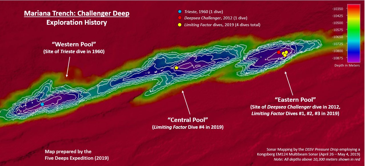
Sonar Map of the Challenger Deep and Historical Dive Annotations
Summary[edit]
| Description |
English: This map was created by the DSSV Pressure Drop's Kngsberg EM124 sonar system over the course of two weeks to map the Challenger Deep in the Marianas Trench. The Deep consists of three "pools" of varying depth with the central pool being the most shallow, then the western one, with the eastern pool measured to be the deepest at 10,925 meters. That depth was measured using the manned submersible DSV Limiting Factor on April 28 - May 3, 2019 as part of the Five Deeps Expedition. |
| Date | |
| Source | Own work |
| Author | Vlvescovo |
Licensing[edit]
I, the copyright holder of this work, hereby publish it under the following license:
This file is licensed under the Creative Commons Attribution-Share Alike 4.0 International license.
- You are free:
- to share – to copy, distribute and transmit the work
- to remix – to adapt the work
- Under the following conditions:
- attribution – You must give appropriate credit, provide a link to the license, and indicate if changes were made. You may do so in any reasonable manner, but not in any way that suggests the licensor endorses you or your use.
- share alike – If you remix, transform, or build upon the material, you must distribute your contributions under the same or compatible license as the original.
File history
Click on a date/time to view the file as it appeared at that time.
| Date/Time | Thumbnail | Dimensions | User | Comment | |
|---|---|---|---|---|---|
| current | 22:06, 11 October 2019 | | 1,278 × 584 (141 KB) | Vlvescovo (talk | contribs) | User created page with UploadWizard |
You cannot overwrite this file.
File usage on Commons
There are no pages that use this file.
File usage on other wikis
The following other wikis use this file:
- Usage on ar.wikipedia.org
- Usage on de.wikipedia.org
- Usage on en.wikipedia.org
- Usage on ga.wikipedia.org
- Usage on ka.wikipedia.org
- Usage on lv.wikipedia.org
- Usage on pl.wikipedia.org