File:Chanthu 2016 track.png
跳至導覽
跳至搜尋

預覽大小:600 × 600 像素。 其他解析度:240 × 240 像素 | 480 × 480 像素 | 768 × 768 像素 | 1,024 × 1,024 像素 | 2,048 × 2,048 像素 | 2,700 × 2,700 像素。
原始檔案 (2,700 × 2,700 像素,檔案大小:3.23 MB,MIME 類型:image/png)
說明
說明
添加單行說明來描述出檔案所代表的內容
摘要
| 描述 |
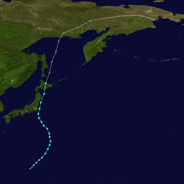
English: Track map of Severe Tropical Storm Chanthu of the 2016 Pacific typhoon season. The points show the location of the storm at 6-hour intervals. The colour represents the storm's maximum sustained wind speeds as classified in the (see below), and the shape of the data points represent the nature of the storm, according to the legend below. Tropical depression (≤38 mph, ≤62 km/h)
Tropical storm (39–73 mph, 63–118 km/h)
Category 1 (74–95 mph, 119–153 km/h)
Category 2 (96–110 mph, 154–177 km/h)
Category 3 (111–129 mph, 178–208 km/h)
Category 4 (130–156 mph, 209–251 km/h)
Category 5 (≥157 mph, ≥252 km/h)
Unknown
Storm type |
||
| 日期 | 2016-08-12–2016-08-20 | ||
| 來源 | Created by Supportstorm using Wikipedia:WikiProject Tropical cyclones/Tracks. The background image is from NASA. Tracking data is from the Joint Typhoon Warning Center[1]. | ||
| 作者 | Supportstorm | ||
| Source code | Track map data table, if present below, is in HURDAT2 or ATCF format. See format details in [2] and [3], respectively.
|
授權條款
[編輯]| 此作品已由其作者,Supportstorm,釋出至公有領域。此授權條款在全世界均適用。 這可能在某些國家不合法,如果是的話: Supportstorm授予任何人有權利使用此作品於任何用途,除受法律約束外,不受任何限制。 |
檔案歷史
點選日期/時間以檢視該時間的檔案版本。
| 日期/時間 | 縮圖 | 尺寸 | 用戶 | 備註 | |
|---|---|---|---|---|---|
| 目前 | 2020年2月12日 (三) 01:57 | | 2,700 × 2,700(3.23 MB) | Supportstorm(對話 | 貢獻) | JTWC/JMA data |
| 2019年8月19日 (一) 18:17 |  | 2,700 × 2,700(3.52 MB) | Supportstorm(對話 | 貢獻) | Extended JMA ET track from weather charts | |
| 2017年10月5日 (四) 05:46 |  | 2,700 × 2,700(4.44 MB) | Supportstorm(對話 | 貢獻) | IBTrACS version | |
| 2017年4月5日 (三) 07:39 |  | 2,700 × 2,700(4.51 MB) | A1Cafel(對話 | 貢獻) | Reverted to version as of 12:31, 21 September 2016 (UTC): Follow JMA Best track! | |
| 2017年3月19日 (日) 04:11 |  | 2,700 × 2,700(3.48 MB) | Morgan Siu(對話 | 貢獻) | Reverted to version as of 04:08, 19 March 2017 (UTC) | |
| 2017年3月19日 (日) 04:10 |  | 2,700 × 2,700(4.51 MB) | Morgan Siu(對話 | 貢獻) | 應該顯示燦都的溫帶氣旋部分 | |
| 2017年3月19日 (日) 04:08 |  | 2,700 × 2,700(3.48 MB) | Morgan Siu(對話 | 貢獻) | Reverted to version as of 08:11, 5 March 2017 (UTC) | |
| 2017年3月13日 (一) 16:14 |  | 2,700 × 2,700(4.51 MB) | A1Cafel(對話 | 貢獻) | Reverted to version as of 12:31, 21 September 2016 (UTC) | |
| 2017年3月5日 (日) 08:11 |  | 2,700 × 2,700(3.48 MB) | Morgan Siu(對話 | 貢獻) | Reverted to version as of 15:33, 20 August 2016 (UTC) | |
| 2016年9月21日 (三) 12:31 |  | 2,700 × 2,700(4.51 MB) | Supportstorm(對話 | 貢獻) | JMA best track ET |
無法覆蓋此檔案。
檔案用途
下列頁面有用到此檔案:
- File:09W 2016 track.png (檔案重新導向)
全域檔案使用狀況
以下其他 wiki 使用了這個檔案:
- de.wikipedia.org 的使用狀況
- en.wikipedia.org 的使用狀況
- es.wikipedia.org 的使用狀況
- ja.wikipedia.org 的使用狀況
- ko.wikipedia.org 的使用狀況
- pt.wikipedia.org 的使用狀況
- th.wikipedia.org 的使用狀況
- vi.wikipedia.org 的使用狀況
- zh-yue.wikipedia.org 的使用狀況
- zh.wikipedia.org 的使用狀況