File:Chariot spread.png
跳转到导航
跳转到搜索
没有更高的分辨率。
Chariot_spread.png (400 × 231像素,文件大小:154 KB,MIME类型:image/png)
说明
说明
添加一行文字以描述该文件所表现的内容
| 描述 |
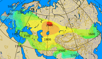
Historical spread of the chariot. This map combines various classes of information, historical and archaeological. The 'isochrones' as given should not be considered more than rough approximations, give or take a century.
|
||||||||
| 日期 | |||||||||
| 来源 | 自己的作品 by by en:User:Dbachmann | ||||||||
| 作者 | by en:User:Dbachmann | ||||||||
| 授权 (二次使用本文件) |
|
||||||||
| 其他版本 |
|


文件历史
点击某个日期/时间查看对应时刻的文件。
| 日期/时间 | 缩略图 | 大小 | 用户 | 备注 | |
|---|---|---|---|---|---|
| 当前 | 2021年9月27日 (一) 04:00 | | 400 × 231(154 KB) | GPinkerton(留言 | 贡献) | Reverted to version as of 14:14, 17 August 2005 (UTC) COM:CROP |
| 2021年5月2日 (日) 19:28 |  | 400 × 231(161 KB) | Claude Zygiel(留言 | 贡献) | North Africa too (Raymond Vaufrey, Préhistoire de l'Afrique, tome II, Service des Publications de l'Université de Tunis, 1969) | |
| 2005年8月17日 (三) 14:14 |  | 400 × 231(154 KB) | Dbachmann(留言 | 贡献) | correction, labels | |
| 2005年8月17日 (三) 07:14 |  | 350 × 202(119 KB) | Dbachmann(留言 | 贡献) | by en:User:Dbachmann {{GFDL}} |
您不可以覆盖此文件。
文件用途
以下6个页面使用本文件:
全域文件用途
以下其他wiki使用此文件:
- az.wikipedia.org上的用途
- ba.wikipedia.org上的用途
- bn.wikipedia.org上的用途
- ca.wikipedia.org上的用途
- cs.wikipedia.org上的用途
- da.wikipedia.org上的用途
- de.wikipedia.org上的用途
- en.wikipedia.org上的用途
- es.wikipedia.org上的用途
- eu.wikipedia.org上的用途
- fa.wikipedia.org上的用途
- fi.wikipedia.org上的用途
- fi.wikibooks.org上的用途
- fr.wikipedia.org上的用途
- hak.wikipedia.org上的用途
- he.wikipedia.org上的用途
- hu.wikipedia.org上的用途
- hy.wikipedia.org上的用途
查看本文件的更多全域用途。
元数据
分类:
- Ancient four-wheeled chariots
- War chariots
- Maps of the Sintashta culture
- Archaeological maps
- Maps showing 2nd-millennium BC history
- Maps showing 1st-millennium BC history
- Maps showing 20th-century BC history
- Maps showing 19th-century BC history
- Maps showing 18th-century BC history
- Maps showing 17th-century BC history
- Maps showing 16th-century BC history
- 12th century BC
- 10th century BC
- 6th century BC
- 5th century BC
- Maps of the Bronze Age in China
- Isochrone maps
- Transport statistics