File:Chavalon - Plan des bâtiments.svg
Jump to navigation
Jump to search

Size of this PNG preview of this SVG file: 574 × 599 pixels. Other resolutions: 230 × 240 pixels | 460 × 480 pixels | 735 × 768 pixels | 981 × 1,024 pixels | 1,961 × 2,048 pixels | 588 × 614 pixels.
Original file (SVG file, nominally 588 × 614 pixels, file size: 44 KB)
Captions
Captions
The buildings of the Chavalon plant.
Summary[edit]
| Description |
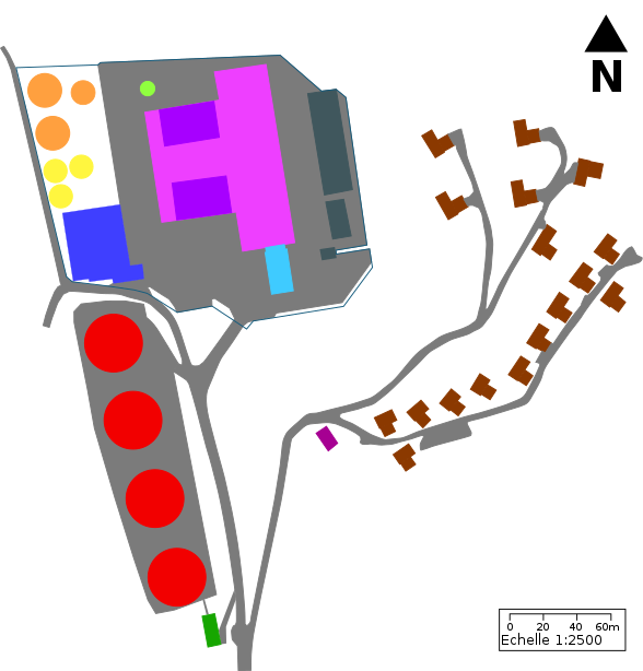
English: View from the top of the buildings of Chavalon. This was made with Inkscape using a satelite view from SwissTopo.
The buildings of the Chavalon plant: cooling towers (red), water treatment plant (green), workshops and shops (dark blue), circulating water treatment (yellow), fuel storage (orange), chimney (light green), factory (pink), boilers (lighter purple), administrative offices (light blue), 220 kV transformer station (grey), cable car departure station (purple) and villas (brown).
Français : Vue du dessus des bâtiments de l'usine de Chavalon. Ce plan a été créé avec Inkscape à partir d'une image satellite de SwissTopo.
Les bâtiments de l'usine de Chavalon : tours de refroidissement (rouge), station d'épuration (vert), ateliers et magasins (bleu foncé), traitement de l'eau de circulation (jaune), stockage des combustibles (orange), cheminée (vert clair), usine (rose), chaudières (violet), bureaux administratifs (bleu clair), station de transformation 220 kV (gris), station de départ du téléphérique (violet) et villas (brun). |
| Date | |
| Source | Own work |
| Author | Christian David |
Licensing[edit]
I, the copyright holder of this work, hereby publish it under the following license:
This file is licensed under the Creative Commons Attribution-Share Alike 4.0 International license.
- You are free:
- to share – to copy, distribute and transmit the work
- to remix – to adapt the work
- Under the following conditions:
- attribution – You must give appropriate credit, provide a link to the license, and indicate if changes were made. You may do so in any reasonable manner, but not in any way that suggests the licensor endorses you or your use.
- share alike – If you remix, transform, or build upon the material, you must distribute your contributions under the same or compatible license as the original.
File history
Click on a date/time to view the file as it appeared at that time.
| Date/Time | Thumbnail | Dimensions | User | Comment | |
|---|---|---|---|---|---|
| current | 19:17, 16 January 2022 | | 588 × 614 (44 KB) | Espandero (talk | contribs) | Better contour on roads, changed contour of buildings, added roads around the main building |
| 15:56, 3 January 2022 |  | 588 × 614 (41 KB) | Espandero (talk | contribs) | Uploaded own work with UploadWizard |
You cannot overwrite this file.
File usage on Commons
There are no pages that use this file.
File usage on other wikis
The following other wikis use this file:
- Usage on fr.wikipedia.org
- Usage on nl.wikipedia.org