File:Chemins de fer Aigle–Leysin.svg
Jump to navigation
Jump to search

Size of this PNG preview of this SVG file: 767 × 600 pixels. Other resolutions: 307 × 240 pixels | 614 × 480 pixels | 982 × 768 pixels | 1,280 × 1,001 pixels | 2,560 × 2,002 pixels | 1,556 × 1,217 pixels.
Original file (SVG file, nominally 1,556 × 1,217 pixels, file size: 1.03 MB)
Captions
Captions
Add a one-line explanation of what this file represents
Summary
[edit]
| Description |
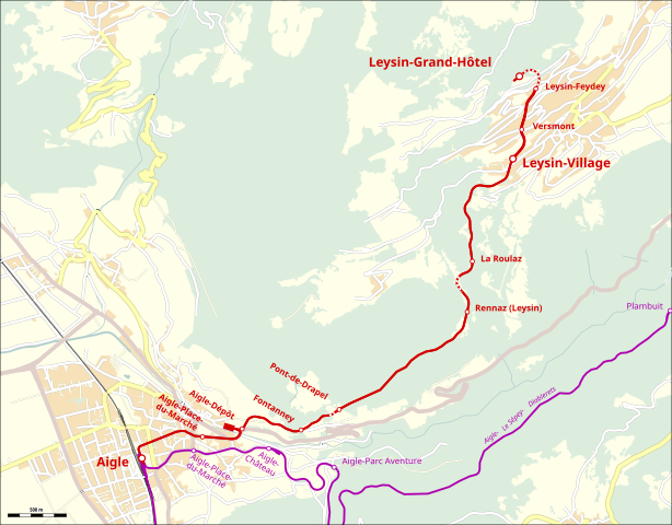
Deutsch: Verlauf der Chemins de fer Aigle–Leysin |
| Date | |
| Source |
Map was created using:
|
| Creator |
|
| Permission (Reusing this file) |
Map data (c) OpenStreetMap (and) contributors, CC-BY-SA |
Licensing
[edit]
| This work is licensed under the Open Database License (summary). |
File history
Click on a date/time to view the file as it appeared at that time.
| Date/Time | Thumbnail | Dimensions | User | Comment | |
|---|---|---|---|---|---|
| current | 19:39, 31 January 2020 | | 1,556 × 1,217 (1.03 MB) | Pechristener (talk | contribs) | improved version with ASD |
| 22:16, 27 January 2020 |  | 1,556 × 1,217 (1.01 MB) | Pechristener (talk | contribs) | == {{int:filedesc}} == {{Map |Description={{de|Verlauf der Chemins de fer Aigle–Leysin}} |Source=Map was created using: * [http://www.openstreetmap.org/ Open Street Map] Data |Date=2020-01-27 |Author= * Raw data: OpenStreetMap contributers * Map rendering: Pechristener using [http://maperitive.net/ Maperitive] |Permission=Map data (c) OpenStreetMap (and) contributors, CC-BY-SA |other_versions= |warp_status=skip }} == {{int:license-header}} == {{ODbL}} [[Category... |
You cannot overwrite this file.
File usage on Commons
There are no pages that use this file.
File usage on other wikis
The following other wikis use this file:
- Usage on de.wikipedia.org
- Usage on it.wikipedia.org