File:Chennai.png
Ir a la navegación
Ir a la búsqueda
Manam kanchu aswan huyakuyuq rikcha.
Chennai.png (219 × 164 iñu; willañiqip chhikan kaynin: 13 kB; MIME laya: image/png)
Leyendas
Leyendas
Añade una explicación corta acerca de lo que representa este archivo
| T'iktuna |
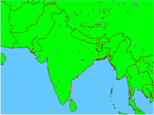
English: This is an incorrect representation of the Republic of India. For a proper geographically correct version of the Republic of India click here: http://www.worldatlas.com/webimage/countrys/asia/lgcolor/incolor.htm This map is an objective illustration showing even the "disputed" region of Kashmir which forms an integral part of India. This map was generated using all open-source software on an open-source unix operating system. The map itself and the marking of the co-ordinates were done using GMT software, and conversion to png format was done using ImageMagick. Please notice this is different form using graphics arts software tools to create maps or other pictures. In fact, this map was created by issuing only 3 command lines from a unix shell, without even using any GUI -- and GUI was used only to view the final picture before uploading it. GMT is a geographic and cartographic set of tools, with extensive capabilities and options. |
| P'unchaw | |
| Pukyu | Kikinpa rurasqan |
| Ruraq | Desconocido |

|
Saqillayqa huñikusqam kay atiqllata iskaychaypaq, mast'ariypaq icha wakinchaypaq kay saqillaypa phatankunakama: GNU Free Documentation License, musuqchasqa 1.2 icha ima qhipaqnin kaq musuqchasqapas Free Software Foundation nisqap uyaychasqan; mana "mana wakinchana rakinakuna", "ñawpaq qata p'anqa" icha "qhipaq qata p'anqa" nisqa qillqayuq. Saqillaypa iskaychasqanqa GNU Free Documentation License nisqa rakipi ch'aqtasqam. |
| Kay willañiqiqa Creative Commons nisqap kay hinallataq rakinakuy 3.0 mana apasqa saqillayninwanmi saqillasqa. | ||
| ||
| Kay saqillay unanchachaqa GFDL saqillay musuqchaywanmi kay willañiqiman yapasqa. |
Willañiqip wiñay kawsaynin
P'unchaw/pacha nisqapi ñit'iy chaypacha willañiqi kachkasqata qhawanaykipaq.
| P'unchaw/Pacha | Uchuylla rikchacha | Chhikanyachikuqkuna | Ruraq | Willapuy | |
|---|---|---|---|---|---|
| kunan | 13:51 6 ini 2005 | | 219 × 164 (13 kB) | Sebastian Wallroth (rimanakuy | llamk'apusqakuna) | This is an incorrect representation of the Republic of India. For a proper geographically correct version of the Republic of India click here: http://www.worldatlas.com/webimage/countrys/asia/lgcolor/incolor.htm This map is an objective illustration showi |
Manam atinkichu kay willañiqita huknachayta.
Maypim willañiqita llamk'achinku
Kay rikchamanqa manam ima p'anqakunachu t'inkimun.
Mayqin wikikunapi willañiqita llamk'achinku
Kay wakin wikikunam willañiqitaqa llamk'achinku: