File:Chernyakhov.PNG
Salta a la navegació
Salta a la cerca
No hi ha cap versió amb una resolució més gran.
Chernyakhov.PNG (777 × 471 píxels, mida del fitxer: 10 Ko, tipus MIME: image/png)
Llegendes
Llegendes
Afegeix una explicació d'una línia del que representa aquest fitxer
Resum[modifica]

|
File:Chernyakhov.svg és una versió vectorial (SVG) d'aquest fitxer. En cas de ser millor, hauria de ser emprada en lloc d'aquesta imatge tramada.
File:Chernyakhov.PNG → File:Chernyakhov.svg
Per a més informació pel que fa als gràfics vectorials, llegiu la transició a SVG en Commons. També hi ha informació quant a la compatibilitat del MediaWiki amb les imatges SVG. |
 |
| Descripció |
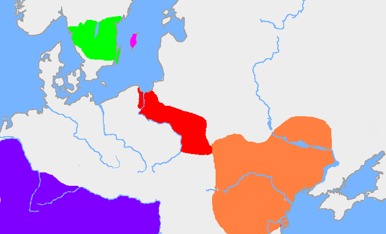
English: The green area is the traditional extent of Götaland and the pink area is the island of Gotland. The red area is the extent of the Wielbark culture in the early 3rd century, and the orange area is the Chernyakhov culture, in the early 4th century. The purple area is the Roman Empire.
The extent of the Wielbark culture is based on Zbigniew Babik: "Najstarsza warstwa nazewnicza na ziemiach polskich" Cracow 2001. The extent of the Chernyakhov culture is based on R. Wołągiewicz (1993), a map drawn by Lars Östlin, in Kaliff's Gothic Connections. Contacts between eastern Scandinavia and the southern Baltic coast 1000 BC – 500 AD (2001:29)Deutsch: Ungefähre Ausbildung der Chernjachov-Kultur im 3. Jahrhundert (orange) und der Wielbark-Kultur (rot). |
| Font | Wiglaf's map, based on Dbachmann's blank map. |
| Autor | en:User:Wiglaf, en:User:Dbachmann |
Llicència[modifica]

|
S'autoritza la còpia, la distribució i la modificació d'aquest document sota els termes de la llicència de documentació lliure GNU versió 1.2 o qualsevol altra versió posterior que publiqui la Free Software Foundation; sense seccions invariants, ni textos de portada, ni textos de contraportada. S'inclou una còpia d'aquesta llicència en la secció titulada GNU Free Documentation License. |
| Aquest fitxer està subjecte a la llicència de Creative Commons Reconeixement i Compartir Igual 3.0 No adaptada. | ||
| ||
| Aquest avís de llicència s'ha afegit a aquest fitxer d'acord amb l'actualització de la llicència GFDL. |
Image history[modifica]
| date/time | username | edit summary |
|---|---|---|
| 22:03, 19 August 2005 | en:User:Wiglaf | |
| 20:55, 26 July 2005 | en:User:Wiglaf | |
| 13:04, 26 July 2005 | en:User:Wiglaf | |
| 12:57, 26 July 2005 | en:User:Wiglaf |
Historial del fitxer
Cliqueu una data/hora per veure el fitxer tal com era aleshores.
| Data/hora | Miniatura | Dimensions | Usuari/a | Comentari | |
|---|---|---|---|---|---|
| actual | 03:34, 9 gen 2022 | | 777 × 471 (10 Ko) | Jul059 (discussió | contribucions) | Lossless file size reduction |
| 16:57, 4 març 2006 |  | 777 × 471 (25 Ko) | Maksim (discussió | contribucions) | La bildo estas kopiita de wikipedia:en. La originala priskribo estas: my own map, based on User:Dbachmann's blank map. The extent of the Wielbark culture is based on Zbigniew Babik: "Najstarsza warstwa nazewnicza na ziemiach polskich" Cracow 200 |
No podeu sobreescriure aquest fitxer.
Ús del fitxer
Les 3 pàgines següents utilitzen aquest fitxer:
Ús global del fitxer
Utilització d'aquest fitxer en altres wikis:
- Utilització a af.wikipedia.org
- Utilització a an.wikipedia.org
- Utilització a ar.wikipedia.org
- Utilització a arz.wikipedia.org
- Utilització a ba.wikipedia.org
- Utilització a be-tarask.wikipedia.org
- Utilització a be.wikipedia.org
- Utilització a bg.wikipedia.org
- Utilització a bs.wikipedia.org
- Utilització a ca.wikipedia.org
- Utilització a cv.wikipedia.org
- Utilització a da.wikipedia.org
- Utilització a de.wikipedia.org
- Utilització a de.wikibooks.org
- Utilització a el.wikipedia.org
- Utilització a en.wikipedia.org
Vegeu més usos globals d'aquest fitxer.