File:Chernyakhov.PNG
跳转到导航
跳转到搜索
没有更高的分辨率。
Chernyakhov.PNG (777 × 471像素,文件大小:10 KB,MIME类型:image/png)
说明
说明
添加一行文字以描述该文件所表现的内容
摘要
[编辑]

|
File:Chernyakhov.svg是此文件的矢量版本。 如果此文件质量不低于原点阵图,就应该将这个PNG格式文件替换为此文件。
File:Chernyakhov.PNG → File:Chernyakhov.svg
更多信息请参阅Help:SVG/zh。 |
 |
| 描述 |
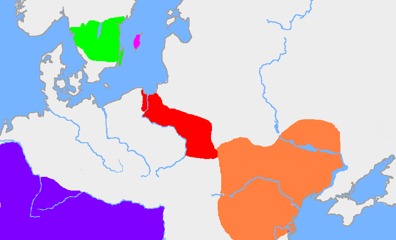
English: The green area is the traditional extent of Götaland and the pink area is the island of Gotland. The red area is the extent of the Wielbark culture in the early 3rd century, and the orange area is the Chernyakhov culture, in the early 4th century. The purple area is the Roman Empire.
The extent of the Wielbark culture is based on Zbigniew Babik: "Najstarsza warstwa nazewnicza na ziemiach polskich" Cracow 2001. The extent of the Chernyakhov culture is based on R. Wołągiewicz (1993), a map drawn by Lars Östlin, in Kaliff's Gothic Connections. Contacts between eastern Scandinavia and the southern Baltic coast 1000 BC – 500 AD (2001:29)Deutsch: Ungefähre Ausbildung der Chernjachov-Kultur im 3. Jahrhundert (orange) und der Wielbark-Kultur (rot). |
| 来源 | Wiglaf's map, based on Dbachmann's blank map. |
| 作者 | en:User:Wiglaf, en:User:Dbachmann |
许可协议
[编辑]

|
已授权您依据自由软件基金会发行的无固定段落及封面封底文字(Invariant Sections, Front-Cover Texts, and Back-Cover Texts)的GNU自由文件许可协议1.2版或任意后续版本的条款,复制、传播和/或修改本文件。该协议的副本请见“GNU Free Documentation License”。 |
| 本文件采用知识共享署名-相同方式共享 3.0 未本地化版本许可协议授权。 | ||
| ||
| 本许可协议标签作为GFDL许可协议更新的组成部分被添加至本文件。 |
Image history
[编辑]
| date/time | username | edit summary |
|---|---|---|
| 22:03, 19 August 2005 | en:User:Wiglaf | |
| 20:55, 26 July 2005 | en:User:Wiglaf | |
| 13:04, 26 July 2005 | en:User:Wiglaf | |
| 12:57, 26 July 2005 | en:User:Wiglaf |
文件历史
点击某个日期/时间查看对应时刻的文件。
| 日期/时间 | 缩略图 | 大小 | 用户 | 备注 | |
|---|---|---|---|---|---|
| 当前 | 2022年1月9日 (日) 03:34 | | 777 × 471(10 KB) | Jul059(留言 | 贡献) | Lossless file size reduction |
| 2006年3月4日 (六) 16:57 |  | 777 × 471(25 KB) | Maksim(留言 | 贡献) | La bildo estas kopiita de wikipedia:en. La originala priskribo estas: my own map, based on User:Dbachmann's blank map. The extent of the Wielbark culture is based on Zbigniew Babik: "Najstarsza warstwa nazewnicza na ziemiach polskich" Cracow 200 |
您不可以覆盖此文件。
文件用途
以下3个页面使用本文件:
全域文件用途
以下其他wiki使用此文件:
- af.wikipedia.org上的用途
- an.wikipedia.org上的用途
- ar.wikipedia.org上的用途
- arz.wikipedia.org上的用途
- ba.wikipedia.org上的用途
- be-tarask.wikipedia.org上的用途
- be.wikipedia.org上的用途
- bg.wikipedia.org上的用途
- bs.wikipedia.org上的用途
- ca.wikipedia.org上的用途
- cv.wikipedia.org上的用途
- da.wikipedia.org上的用途
- de.wikipedia.org上的用途
- de.wikibooks.org上的用途
- el.wikipedia.org上的用途
- en.wikipedia.org上的用途
查看此文件的更多全域用途。