File:Chile location map (+claims, 1775).svg

Original file (SVG file, nominally 1,710 × 2,679 pixels, file size: 2.2 MB)
Captions
Captions
Summary[edit]
| Description |
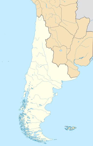
Español: Mapa de localización de la Capitanía General de Chile o Reino de Chile basado en los límites del mapa de la América Meridional hecho por Juan de la Cruz Cano y Olmedilla (1775) y el mapa general del Reyno de Chile de Andrés Baleato (1793) en el sector del desierto de Atacama.
Incluye todas las tierras del continente sudamericano que pobladas o no pertenecían al reino por derecho, entre estas la Patagonia, llamada como Tierras Magallánicas o Chile Moderno. Además incluye el territorio de Cuyo, segregado un año después con la creación del virreinato de la Plata.English: Location map of the Captaincy General of Chile or Kingdom of Chile based on the limits of the map of South America made by Juan de la Cruz Cano y Olmedilla (1775) and the general map of the Kingdom of Chile by Andrés Baleato (1793) in the sector of the Atacama Desert.
It includes all the lands of the South American continent that populated or not belonged to the kingdom by right, among these the Patagonia, called as Magellanic Lands or Modern Chile. It also includes the territory of Cuyo, segregated a year later with the creation of the viceroyalty of La Plata. |
||||||||||||||||||||
| Date | |||||||||||||||||||||
| Source |
This file was derived from: Chile location map.svg by NordNordWest Reino de Chile según Juan de la Cruz Cano y Olmedilla, 1775.jpg Límite entre Chile y Perú en el río Loa, Plano General del Reyno de Chile en la América Meridional de Andrés Baleato (1793).jpg Own work |
||||||||||||||||||||
| Author |
Andrés Baleato
|
||||||||||||||||||||
| Other versions |
    |
||||||||||||||||||||
.jpg)
.svg&action=edit§ion=1)
.jpg)
Licensing[edit]
.svg&action=edit§ion=2)
- You are free:
- to share – to copy, distribute and transmit the work
- to remix – to adapt the work
- Under the following conditions:
- attribution – You must give appropriate credit, provide a link to the license, and indicate if changes were made. You may do so in any reasonable manner, but not in any way that suggests the licensor endorses you or your use.
- share alike – If you remix, transform, or build upon the material, you must distribute your contributions under the same or compatible license as the original.
File history
Click on a date/time to view the file as it appeared at that time.
| Date/Time | Thumbnail | Dimensions | User | Comment | |
|---|---|---|---|---|---|
| current | 20:38, 4 December 2022 | | 1,710 × 2,679 (2.2 MB) | Janitoalevic (talk | contribs) | . |
| 20:37, 4 December 2022 |  | 1,710 × 2,684 (2.2 MB) | Janitoalevic (talk | contribs) | . | |
| 15:39, 22 November 2022 |  | 1,710 × 2,679 (2.04 MB) | Janitoalevic (talk | contribs) | Mejoras | |
| 21:32, 12 November 2022 |  | 1,710 × 2,679 (1.92 MB) | Janitoalevic (talk | contribs) | . | |
| 21:22, 12 November 2022 |  | 1,710 × 2,679 (1.91 MB) | Janitoalevic (talk | contribs) | Fix | |
| 20:33, 11 November 2022 |  | 1,710 × 2,679 (1.76 MB) | Janitoalevic (talk | contribs) | Uploaded own work with UploadWizard |
You cannot overwrite this file.
File usage on Commons
The following 4 pages use this file:
File usage on other wikis
The following other wikis use this file:
- Usage on en.wikipedia.org
- Usage on si.wikipedia.org
- Usage on uz.wikipedia.org
.svg&oldid=856276960)