File:China-Hunan.png
Jump to navigation
Jump to search
No higher resolution available.
China-Hunan.png (268 × 218 pixels, file size: 16 KB, MIME type: image/png)
Captions
Captions
Add a one-line explanation of what this file represents
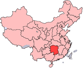
en: Location of Hunan Province in the People's Republic of China. See Locator maps of province-level divisions of the People's Republic of China for more information.
zh: 湖南省在中華人民共和國的位置。另見Locator maps of province-level divisions of the People's Republic of China。

|
Permission is granted to copy, distribute and/or modify this document under the terms of the GNU Free Documentation License, Version 1.2 or any later version published by the Free Software Foundation; with no Invariant Sections, no Front-Cover Texts, and no Back-Cover Texts. A copy of the license is included in the section entitled GNU Free Documentation License. |
| This file is licensed under the Creative Commons Attribution-Share Alike 3.0 Unported license. | ||
| ||
| This licensing tag was added to this file as part of the GFDL licensing update. |

|
File:Map of PRC Hunan.svg is a vector version of this file. It should be used in place of this PNG file when not inferior.
File:China-Hunan.png → File:Map of PRC Hunan.svg
For more information, see Help:SVG. |
 |
File history
Click on a date/time to view the file as it appeared at that time.
| Date/Time | Thumbnail | Dimensions | User | Comment | |
|---|---|---|---|---|---|
| current | 14:52, 15 July 2005 | | 268 × 218 (16 KB) | Schaengel89~commonswiki (talk | contribs) | |
| 21:57, 4 June 2005 |  | 268 × 218 (9 KB) | Ran (talk | contribs) | '''en''': Location of Hunan Province in the People's Republic of China. See Category:Locator maps of province-level divisions of the People's Republic of China for more information. '''zh''': 湖南省在中華人民共和國的位置。另見[[:Cat |
You cannot overwrite this file.
File usage on Commons
The following 3 pages use this file:
File usage on other wikis
The following other wikis use this file:
- Usage on da.wikipedia.org
- Usage on de.wikipedia.org
- Usage on de.wikinews.org
- Usage on en.wikipedia.org
- Xinhua County
- Zi River
- Wulingyuan
- Wikipedia:WikiProject Chinese provinces/Locator maps
- Xiangxi Tujia and Miao Autonomous Prefecture
- Bancang
- Junshan Yinzhen
- Yuanjiang
- Cili County
- Wugai Mountain Hunting Field
- Wugai Mountain
- Suxian Hill
- Jiangyong County
- Luoxiao Mountains
- Loudi
- Jiuyi Mountains
- Xuefeng Mountains
- Junshan Island
- Lianyuan
- Huarong County
- Miluo City
- Xiangxiang
- Zixing
- Lengshuitan, Yongzhou
- Changde Taohuayuan Airport
- Template:Hunan-geo-stub
- Hongjiang District
- Longshan County
- Da'an, Longshan
- Wanmin
- Lifuta
- Mengbi
- Liaojiacun
- Longjiazhai
- Tawo
- Kesha Township
- Nongche
- Shidi, Yongshun
- Ciyantang
- Qingtianping
- Darongxi
- Daping, Rucheng
- Jiaoziya
- Yujiazui
- Zhuyeping
- Jiaba
- Xiche
View more global usage of this file.