File:China Beijing.svg
跳至導覽
跳至搜尋

此 SVG 檔案的 PNG 預覽的大小:705 × 599 像素。 其他解析度:282 × 240 像素 | 565 × 480 像素 | 904 × 768 像素 | 1,205 × 1,024 像素 | 2,409 × 2,048 像素 | 1,000 × 850 像素。
原始檔案 (SVG 檔案,表面大小:1,000 × 850 像素,檔案大小:207 KB)
說明
說明
添加單行說明來描述出檔案所代表的內容

檔案歷史
點選日期/時間以檢視該時間的檔案版本。
| 日期/時間 | 縮圖 | 尺寸 | 用戶 | 備註 | |
|---|---|---|---|---|---|
| 目前 | 2008年8月13日 (三) 16:12 | | 1,000 × 850(207 KB) | Joowwww(對話 | 貢獻) | added missing laos/vietnam border |
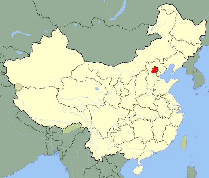
| 2008年5月14日 (三) 11:07 |  | 1,000 × 850(206 KB) | Joowwww(對話 | 貢獻) | {{Information |Description=An SVG map of China with Beijing municipality highlighted Legend:<br />Image:China map legend.png |Source=self-made; based on CIA public domain maps: *http://www.lib.utexas.edu/maps/middle_east_and_asia/china_admin_91.jpg * |
無法覆蓋此檔案。
檔案用途
下列4個頁面有用到此檔案:
全域檔案使用狀況
以下其他 wiki 使用了這個檔案:
- ace.wikipedia.org 的使用狀況
- af.wikipedia.org 的使用狀況
- ang.wikipedia.org 的使用狀況
- arz.wikipedia.org 的使用狀況
- ay.wikipedia.org 的使用狀況
- bjn.wikipedia.org 的使用狀況
- bs.wikipedia.org 的使用狀況
- btm.wikipedia.org 的使用狀況
- cbk-zam.wikipedia.org 的使用狀況
- cdo.wikipedia.org 的使用狀況
- ceb.wikipedia.org 的使用狀況
- ckb.wikipedia.org 的使用狀況
- crh.wikipedia.org 的使用狀況
- cs.wikipedia.org 的使用狀況
- da.wikipedia.org 的使用狀況
- de.wikipedia.org 的使用狀況
- dv.wikipedia.org 的使用狀況
- en.wikipedia.org 的使用狀況
- en.wikinews.org 的使用狀況
- en.wiktionary.org 的使用狀況
- es.wikipedia.org 的使用狀況
- et.wikipedia.org 的使用狀況
- fa.wikipedia.org 的使用狀況
- fiu-vro.wikipedia.org 的使用狀況
- fo.wikipedia.org 的使用狀況
- fr.wikipedia.org 的使用狀況
- Pékin
- Projet:Charte graphique/Domaine géographique
- Modèle:Palette Pékin
- District de Dongcheng
- District de Xicheng
- District de Chongwen
- District de Xuanwu (Pékin)
- District de Chaoyang (Pékin)
- District de Haidian
- District de Fengtai
- District de Shijingshan
- District de Mentougou
- District de Fangshan
- District de Tongzhou
- District de Shunyi
- District de Changping
- District de Daxing
- District de Huairou
檢視此檔案的更多全域使用狀況。