File:China Hubei.svg
跳去導覽
跳去搵嘢

呢個「SVG」檔案嘅呢個「PNG」預覽嘅大細:705 × 599 像素。 第啲解像度:282 × 240 像素 | 565 × 480 像素 | 904 × 768 像素 | 1,205 × 1,024 像素 | 2,409 × 2,048 像素 | 1,000 × 850 像素。
原本檔案 (SVG檔案,表面大細: 1,000 × 850 像素,檔案大細:210 KB)
Captions
Captions
Add a one-line explanation of what this file represents
| 描述 |
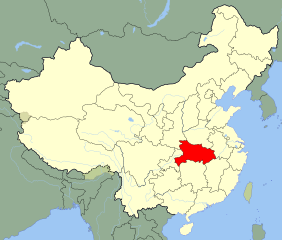
English: An SVG map of China with Hubei province highlighted
Legend:  閩南語 / Bân-lâm-gú:Tiong-kok Ôo-pak-síng (âng-sik) ē uī-tì. 中國湖北省(紅色)的位置。 |
||
| 日期 | |||
| 來源 |
self-made; based on CIA public domain maps: |
||
| 作者 | Joowwww | ||
| 許可 (重用呢個檔案) |
|
||
| Other versions |
Derivative works of this file: Battle of Red Cliffs 208 map-fr.svg |
檔案歷史
撳個日期/時間去睇響嗰個時間出現過嘅檔案。
| 日期/時間 | 縮圖 | 尺寸 | 用戶 | 註解 | |
|---|---|---|---|---|---|
| 現時 | 2008年8月13號 (三) 16:23 | | 1,000 × 850(210 KB) | Joowwww(傾偈 | 貢獻) | added missing laos/vietnam border |
| 2008年5月14號 (三) 11:15 |  | 1,000 × 850(208 KB) | Joowwww(傾偈 | 貢獻) | {{Information |Description=An SVG map of China with Hubei province highlighted Legend:<br />Image:China map legend.png |Source=self-made; based on CIA public domain maps: *http://www.lib.utexas.edu/maps/middle_east_and_asia/china_admin_91.jpg *http:/ |
你無得衾咗個檔案。
檔案用途
以下嘅7版用到呢個檔:
全域檔案使用情況
下面嘅維基都用緊呢個檔案:
- ace.wikipedia.org嘅使用情況
- bg.wikipedia.org嘅使用情況
- bo.wikipedia.org嘅使用情況
- br.wikipedia.org嘅使用情況
- bs.wikipedia.org嘅使用情況
- cdo.wikipedia.org嘅使用情況
- ceb.wikipedia.org嘅使用情況
- cs.wikipedia.org嘅使用情況
- en.wikipedia.org嘅使用情況
- eo.wikipedia.org嘅使用情況
- es.wikipedia.org嘅使用情況
- eu.wikipedia.org嘅使用情況
- fr.wikipedia.org嘅使用情況
- fr.wikivoyage.org嘅使用情況
- gv.wikipedia.org嘅使用情況
- hak.wikipedia.org嘅使用情況
- hr.wikipedia.org嘅使用情況
- hu.wikipedia.org嘅使用情況
- id.wikipedia.org嘅使用情況
- incubator.wikimedia.org嘅使用情況
- ja.wikipedia.org嘅使用情況
- ka.wikipedia.org嘅使用情況
- ko.wikipedia.org嘅使用情況
睇呢個檔案嘅更多全域使用情況。