File:Chinese civil war map 02.jpg
跳转到导航
跳转到搜索

本预览的尺寸:786 × 599像素。 其他分辨率:315 × 240像素 | 630 × 480像素 | 1,007 × 768像素 | 1,141 × 870像素。
原始文件 (1,141 × 870像素,文件大小:183 KB,MIME类型:image/jpeg)
说明
说明
添加一行文字以描述该文件所表现的内容
摘要[编辑]

|
This map has been uploaded by Electionworld from en.wikipedia.org to enable the |
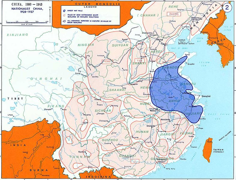
Overview map of Kuomingtang control over China.
From the History Department of the US Military Academy West Point - https://www.westpoint.edu/sites/default/files/inline-images/academics/academic_departments/history/Chinese%20civil%20war/ChineseCivilWar02.pdf
许可协议[编辑]
此作品在美国属于公有领域,因为其是由美国政府的官员或雇员,基于其个人公务目的制作的作品,参考美国法典第17篇第1章第105条。
注意︰本模板仅适用于美国联邦政府的原创作品,不适用于任何美国州、属地、联邦个体、县、市或任何次级政府的作品。本模板也不适用于1978年以后由美国邮政署出版的邮票图案(参看美国版权局实践纲领第313.6(C)(1)条)。也不适用于部分美国硬币;参看美国铸币局使用条款。 |
 | |
| 本文件已被确认为免除已知的著作权法限制(包括所有相关权利)。 | ||
文件历史
点击某个日期/时间查看对应时刻的文件。
| 日期/时间 | 缩略图 | 大小 | 用户 | 备注 | |
|---|---|---|---|---|---|
| 当前 | 2006年12月16日 (六) 14:19 | | 1,141 × 870(183 KB) | Electionworld(留言 | 贡献) | {{ew|en|ChrisO}} Overview map of {{link|Kuomingtang}} control over China. From the History Department of the US Military Academy West Point - http://www.dean.usma.edu/history/web03/atlases/chinese%20civil%20war/chinese%20civil%20war%20pages/chinese%2 |
您不可以覆盖此文件。
文件用途
以下页面使用本文件:
全域文件用途
以下其他wiki使用此文件:
- ca.wikipedia.org上的用途
- el.wikipedia.org上的用途
- en.wikipedia.org上的用途
- fi.wikipedia.org上的用途
- ja.wikipedia.org上的用途
- ko.wikipedia.org上的用途
- lv.wikipedia.org上的用途
- mk.wikipedia.org上的用途
- ms.wikipedia.org上的用途
- my.wikipedia.org上的用途
- nl.wikipedia.org上的用途
- sv.wikipedia.org上的用途
- vi.wikipedia.org上的用途
- zh.wikipedia.org上的用途