File:Chios NASA satellite image.jpg
跳至導覽
跳至搜尋

預覽大小:600 × 600 像素。 其他解析度:240 × 240 像素 | 480 × 480 像素 | 640 × 640 像素。
原始檔案 (640 × 640 像素,檔案大小:305 KB,MIME 類型:image/jpeg)
說明
說明
添加單行說明來描述出檔案所代表的內容
摘要
[編輯]
| 描述 |
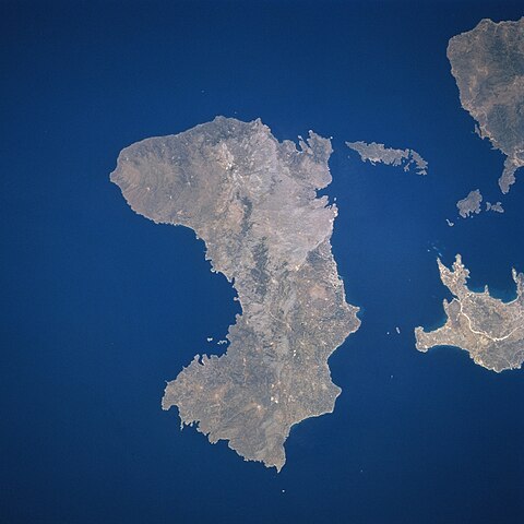
English: Chios, or Khios, Island, Greece
Located in the eastern Aegean Sea just off the coast of western Turkey, the Greek island of Chios can be seen in this near-nadir view. Chios Island is 30 miles (48 km) long and 8 to 15 miles (13 to 24 km) wide and covers an area of 350 sq. miles (905 sq. km). The island is hilly, scenic, and fertile with a good climate. Chios produces olives, figs, and mastic and has marble quarries, lignite deposits, and sulfur springs. Chios is noted in antiquity for its claims as Homer's birthplace and for its school of epic poets, the Homeridae. The land visible at the right center and top right is part of the country of Turkey. |
| 日期 | |
| 來源 | |
| 作者 | NASA |
This file is in the public domain in the United States because it was created by the Image Science & Analysis Laboratory, of the NASA Johnson Space Center. NASA copyright policy states that "NASA material is not protected by copyright unless noted". (NASA media use guidelines or Conditions of Use of Astronaut Photographs).
Photo source: STS078-732-53.
|
原始上傳日誌
[編輯]
| date/time | username | resolution | size | edit summary |
|---|---|---|---|---|
| 2006-09-01T10:41:41Z | User:Badseed | 640×640 | 304.87Kb | rotated 180o so that north is up, as in maps |
| 2006-08-26T23:56:05Z | User:Jkelly | 640×640 | 255.68Kb | {{Information |Description=[[Chios]], or Khios, Island, [[Greece]] Located in the eastern Aegean Sea just off the coast of western [[Turkey]], the Greek island of Chios can be seen in this near-nadir view. Chios Island is 30 miles (48 km) long and 8 to 1 |
檔案歷史
點選日期/時間以檢視該時間的檔案版本。
| 日期/時間 | 縮圖 | 尺寸 | 用戶 | 備註 | |
|---|---|---|---|---|---|
| 目前 | 2009年6月11日 (四) 00:16 | | 640 × 640(305 KB) | BetacommandBot(對話 | 貢獻) | move approved by: User:Telim tor uThis image was moved from File:Chois NASA satellite image.jpg {{Information |Description=Chios, or Khios, Island, Greece Located in the eastern Aegean Sea just off the coast of western [[Türkiye|Turk |
無法覆蓋此檔案。
檔案用途
下列5個頁面有用到此檔案:
全域檔案使用狀況
以下其他 wiki 使用了這個檔案:
- ab.wikipedia.org 的使用狀況
- af.wikipedia.org 的使用狀況
- ar.wikipedia.org 的使用狀況
- arz.wikipedia.org 的使用狀況
- ast.wikipedia.org 的使用狀況
- az.wikipedia.org 的使用狀況
- be.wikipedia.org 的使用狀況
- bg.wikipedia.org 的使用狀況
- br.wikipedia.org 的使用狀況
- ca.wikipedia.org 的使用狀況
- ceb.wikipedia.org 的使用狀況
- cs.wikipedia.org 的使用狀況
- cy.wikipedia.org 的使用狀況
- da.wikipedia.org 的使用狀況
- de.wikipedia.org 的使用狀況
- de.wikivoyage.org 的使用狀況
- el.wikipedia.org 的使用狀況
- en.wikipedia.org 的使用狀況
- es.wikipedia.org 的使用狀況
- et.wikipedia.org 的使用狀況
- eu.wikipedia.org 的使用狀況
- ext.wikipedia.org 的使用狀況
- fr.wiktionary.org 的使用狀況
- fy.wikipedia.org 的使用狀況
- ga.wikipedia.org 的使用狀況
- gl.wikipedia.org 的使用狀況
- he.wikipedia.org 的使用狀況
- hr.wikipedia.org 的使用狀況
- hy.wikipedia.org 的使用狀況
- hyw.wikipedia.org 的使用狀況
- ia.wikipedia.org 的使用狀況
- id.wikipedia.org 的使用狀況
- it.wikipedia.org 的使用狀況
檢視此檔案的更多全域使用狀況。