File:Chrząstowice (gmina) location map.png

Original file (892 × 700 pixels, file size: 187 KB, MIME type: image/png)
Captions
Captions
Summary
[edit]_location_map.png&action=edit§ion=1)
| Description |
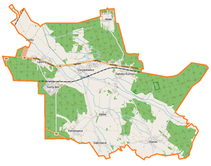
English: Location map |
| Date | |
| Source | Own work |
| Author | Smat |
| Description |
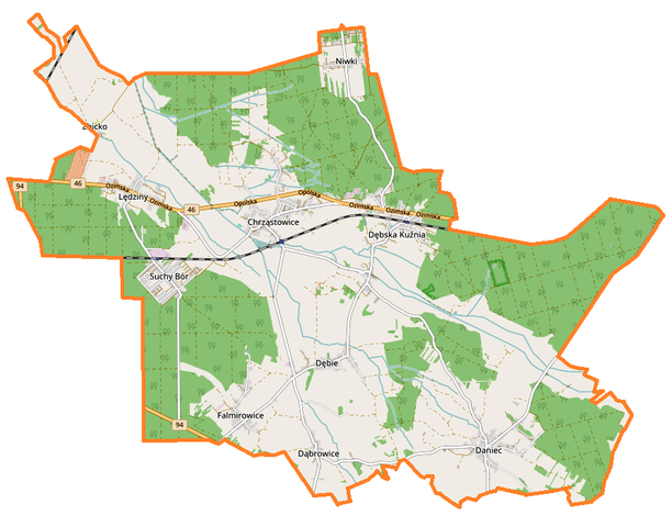
Polski: Mapa gminy Chrząstowice, Polska
English: Map of Chrząstowice (gmina), Poland |
|||||||||
| Date | ||||||||||
| Source | You may find a page on the OpenStreetMap wiki page for Chrząstowice (gmina) | |||||||||
| Creator |
OpenStreetMap contributors OpenStreetMap contributors |
|||||||||
| Permission (Reusing this file) |
OpenStreetMap data is available under the Open Database License (details). Map tiles are licensed under the Creative Commons Attribution-ShareAlike 2.0 license (CC-BY-SA 2.0).
This file is licensed under the Creative Commons Attribution-Share Alike 2.0 Generic license.
|
|||||||||
| Geotemporal data | ||||||||||
| Bounding box |
|
|||||||||
| Georeferencing | If inappropriate please set warp_status = skip to hide. | |||||||||
Licensing
[edit]_location_map.png&action=edit§ion=2)
| This work contains information from OpenStreetMap, which is made available under the Open Database License (ODbL).
The ODbL does not require any particular license for maps produced from ODbL data. Prior to 1 August 2020, map tiles produced by the OpenStreetMap Foundation were licensed under the CC-BY-SA-2.0 license. Maps produced by other people may be subject to other licences. |
File history
Click on a date/time to view the file as it appeared at that time.
| Date/Time | Thumbnail | Dimensions | User | Comment | |
|---|---|---|---|---|---|
| current | 19:07, 27 February 2017 | | 892 × 700 (187 KB) | Smat (talk | contribs) | User created page with UploadWizard |
You cannot overwrite this file.
File usage on Commons
There are no pages that use this file.
File usage on other wikis
The following other wikis use this file:
- Usage on fi.wikipedia.org
- Usage on pl.wikipedia.org
- Daniec
- Dębska Kuźnia
- Falmirowice
- Suchy Bór (województwo opolskie)
- Chrząstowice (województwo opolskie)
- Dąbrowice (województwo opolskie)
- Dębie (województwo opolskie)
- Lędziny (województwo opolskie)
- Niwki (powiat opolski)
- Dębska Kuźnia (przystanek kolejowy)
- Chrząstowice (stacja kolejowa)
- Suchy Bór Opolski
- Parafia Niepokalanego Poczęcia Najświętszej Maryi Panny w Chrząstowicach
- Zbicko
- Kamionka (gmina Chrząstowice)
- Parafia św. Anny i św. Jadwigi Śląskiej w Dębskiej Kuźni
- Kościół Niepokalanego Poczęcia Najświętszej Maryi Panny w Chrząstowicach
- Kościół Matki Bożej Wspomożenia Wiernych w Lędzinach
- Kościół św. Anny i św. Jadwigi Śląskiej w Dębskiej Kuźni
- Parafia Narodzenia Najświętszej Maryi Panny w Dębiu
- Kościół Narodzenia Najświętszej Maryi Panny w Dębiu
- Kościół św. Józefa Robotnika w Dańcu
- Moduł:Mapa/dane/Chrząstowice (gmina)
- Rezerwat przyrody Srebrne Źródła
- Parafia Podwyższenia Krzyża Świętego w Suchym Borze
- Usage on pl.wikibooks.org
_location_map.png&oldid=858212727)