File:Cimaron 2006-10-29 0500Z (cropped).jpg

原始檔案 (6,000 × 6,000 像素,檔案大小:4.18 MB,MIME 類型:image/jpeg)
說明
說明
摘要
[編輯]| 描述 |
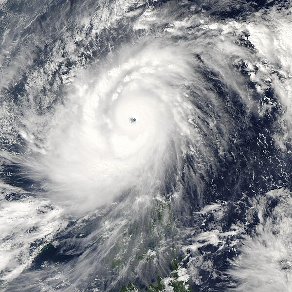
Super Typhoon Cimaron struck the northernmost large island in the Philippines, Luzon, on October 29, 2006. According to BBC News Service, the typhoon was the most powerful to strike the island chain since 1998, lashing Luzon with 200-kilometer-an-hour (125-mile-per-hour) winds and torrential rain. As of October 30, 13 deaths directly attributable to the storm had been reported. This photo-like image was acquired by the Moderate Resolution Imaging Spectroradiometer (MODIS) on the Aqua satellite on October 29, 2006, at 1:00 p.m. local time (5:00 UTC). Super Typhoon Cimaron was a tightly wound ball of clouds just hours from landfall on Luzon. Winds were around 255 kilometers per hour (160 miles per hour) at the time of this image, according to Weather Underground’s Hurricane Archive. As the storm came ashore, it eased off these Category 5-strength winds, but it still struck the mountainous islands with Category 4 winds hours after this satellite image was taken. The high-resolution image provided above is at MODIS’ full spatial resolution (level of detail) of 250 meters per pixel. The MODIS Rapid Response System provides this image at additional resolutions. |
|||||
| 日期 | ||||||
| 來源 | http://earthobservatory.nasa.gov/NaturalHazards/natural_hazards_v2.php3?img_id=13946 | |||||
| 作者 | NASA image by Jeff Schmaltz, MODIS Rapid Response Team, Goddard Space Flight Center. | |||||
| 授權許可 (重用此檔案) |
|
|||||
| 其他版本 | Image:Super Typhoon Cimaron 29 oct 2006 0500Z.jpg |

.jpg&action=edit§ion=1)
檔案歷史
點選日期/時間以檢視該時間的檔案版本。
| 日期/時間 | 縮圖 | 尺寸 | 使用者 | 備註 | |
|---|---|---|---|---|---|
| 目前 | 2006年11月2日 (四) 03:39 | | 6,000 × 6,000(4.18 MB) | Good kitty(留言 | 貢獻) | larger version |
| 2006年10月30日 (一) 20:04 |  | 5,000 × 5,000(6.53 MB) | Coredesat(留言 | 貢獻) | {{Information |Description=250m resolution MODIS image of Typhoon Cimaron (2006) near peak intensity, just prior to landfall over Luzon in the Philippines. |Source=[http://rapidfire.sci.gsfc.nasa.gov/gallery/ MODIS Rapid Response Gallery], [http://rapidfi |
無法覆蓋此檔案。
檔案用途
下列頁面有用到此檔案:
- File:TY Cimaron 2006 peak.jpg (檔案重新導向)
全域檔案使用狀況
以下其他 wiki 使用了這個檔案:
- de.wikipedia.org 的使用狀況
- en.wikipedia.org 的使用狀況
- en.wikinews.org 的使用狀況
- ja.wikipedia.org 的使用狀況
- ko.wikipedia.org 的使用狀況
- nl.wikipedia.org 的使用狀況
- pt.wikipedia.org 的使用狀況
- vi.wikipedia.org 的使用狀況
- zh.wikipedia.org 的使用狀況
.jpg&oldid=860897080)