File:CisleitaniaTransleitaniaYBosniaHercegovina.svg
跳去導覽
跳去搵嘢

呢個「SVG」檔案嘅呢個「PNG」預覽嘅大細:776 × 600 像素。 第啲解像度:311 × 240 像素 | 621 × 480 像素 | 994 × 768 像素 | 1,280 × 989 像素 | 2,560 × 1,978 像素 | 783 × 605 像素。
原本檔案 (SVG檔案,表面大細: 783 × 605 像素,檔案大細:676 KB)
Captions
Captions
Add a one-line explanation of what this file represents
| 描述 |
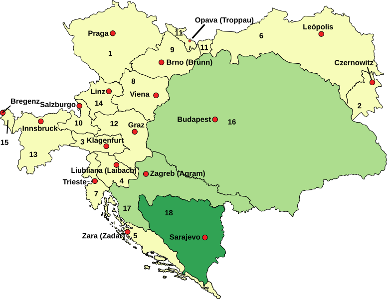
English: Austria–Hungary: Empire of Austria (Cisleithania): 1. Bohemia, 2. Bukovina, 3. Carinthia, 4. Carniola, 5. Dalmatia, 6. Galicia, 7. Küstenland, 8. Lower Austria, 9. Moravia, 10. Salzburg, 11. Silesia, 12. Styria, 13. Tyrol, 14. Upper Austria, 15. Vorarlberg; Kingdom of Hungary (Transleithania): 16. Hungary proper 17. Croatia-Slavonia; Austrian-Hungarian Co-dominion: 18. Bosnia and Herzegovina Deutsch: Österreich-Ungarn 1910: Cisleithanien: 1. Böhmen, 2. Bukowina, 3. Kärnten, 4. Krain, 5. Dalmatien, 6. Galizien, 7. Küstenland, 8. Österreich unter der Enns, 9. Mähren, 10. Salzburg, 11. Schlesien, 12. Steiermark, 13. Tirol, 14. Österreich ob der Enns, 15. Vorarlberg; Transleithanien: 16. Ungarn, 17. Kroatien und Slawonien; 18. Bosnien und Herzegowina Español: Austria–Hungría con sus dos unidades, Cisletitania y Transleitania y la provincia compartida de Bosnia.: Imperio Austriaco (Cisleitania): 1. Bohemia, 2. Bucovina, 3. Carintia, 4. Carniola, 5. Dalmacia, 6. Galicia, 7. Provincia costera 8. Baja Austria, 9. Moravia, 10. Salzburgo, 11. Silesia, 12. Estiria, 13. Tirol, 14. Alta Austria, 15. Vorarlberg; Reino de Hungría (Transleitania): 16. Hungría 17. Croacia-Eslavonia; Condomio austro-magiar: 18. Bosnia y Hercegovina |
| 日期 | (UTC) |
| 來源 | |
| 作者 |
|
| This is a retouched picture, which means that it has been digitally altered from its original version. Modifications: colours changed to show the 2 Imperial units and Bosnia. The original can be viewed here: Austria-Hungary map ES.svg:
|
呢個檔案用共享創意 姓名標示-非商業性-相同方式分享3.0 未本地化版本條款授權。
- 你可以:
- 去分享 – 複製、發佈同傳播呢個作品
- 再改 – 創作演繹作品
- 要遵照下面嘅條件:
- 署名 – 你一定要畀合適嘅表彰、畀返指向呢個授權條款嘅連結,同埋寫明有無改過嚟。你可以用任何合理方式去做,但唔可以用任何方式暗示授權人認可咗你或者你嘅使用方式。
- 相同方式分享 – 如果你用任何方式改過呢個作品,你必須要用返原本或者相似嘅條款發佈。
Original upload log[編輯]
This image is a derivative work of the following images:
- File:Austria-Hungary_map_ES.svg licensed with PD-user-w
- 2010-02-11T17:35:58Z Rowanwindwhistler 783x605 (346541 Bytes) {{Information |Description={{en| '''Austria–Hungary''':'''Empire of Austria (Cisleithania)''': 1. Bohemia, 2. Bukovina, 3. Carinthia, 4. Carniola, 5. Dalmatia, 6. Galicia, 7. Küstenland, 8. Lower Austria, 9. Moravia, 10. S
Uploaded with derivativeFX
檔案歷史
撳個日期/時間去睇響嗰個時間出現過嘅檔案。
| 日期/時間 | 縮圖 | 尺寸 | 用戶 | 註解 | |
|---|---|---|---|---|---|
| 現時 | 2017年7月29號 (六) 09:22 | | 783 × 605(676 KB) | Rowanwindwhistler(傾偈 | 貢獻) | Minor correction in text |
| 2017年7月14號 (五) 11:48 |  | 783 × 605(620 KB) | Rowanwindwhistler(傾偈 | 貢獻) | Lighter colours, hopefully easier to read. | |
| 2016年11月11號 (五) 15:59 |  | 783 × 605(620 KB) | Rowanwindwhistler(傾偈 | 貢獻) | Leópolis. Fake text added | |
| 2010年11月1號 (一) 00:39 |  | 783 × 605(223 KB) | Rowanwindwhistler(傾偈 | 貢獻) | {{Information |Description={{en| <br>'''<u>Austria–Hungary</u>''':<br>'''Empire of Austria (Cisleithania)''': 1. Bohemia, 2. Bukovina, 3. Carinthia, 4. Carniola, 5. Dalmatia, 6. Galicia, 7. Küstenland, 8. Lower Austria, 9. Moravia, 10. Salzburg, 11. Si |
你無得衾咗個檔案。
檔案用途
以下嘅3版用到呢個檔:
全域檔案使用情況
下面嘅維基都用緊呢個檔案:
- es.wikipedia.org嘅使用情況
- Imperio austrohúngaro
- Moravia
- Compromiso austrohúngaro
- Transleitania
- Cisleitania
- Reino de Croacia-Eslavonia
- Ducado de Carintia
- Hungría durante el periodo del Compromiso austrohúngaro
- Marca de Moravia
- Austria-Hungría durante la Primera Guerra Mundial
- Organización territorial del Imperio austrohúngaro
- zh-yue.wikipedia.org嘅使用情況