File:Claudia crater, Vesta IOTD-298.jpg

Изворна податотека (2.350 × 1.300 пиксели, големина: 812 КБ, MIME-тип: image/jpeg)
Описи
Описи
Опис[уреди]
| Опис |
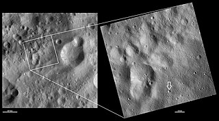
Claudia crater, Vesta. An arrow has been added to the image to point out the crater, which is quite small (equal to the width of the arrow). Original caption: HAMO and LAMO images of Claudia crater Download Image › Full Size September 4, 2012 These Dawn framing camera (FC) images of Vesta show Claudia crater at both HAMO (high-altitude mapping orbit) and LAMO (low-altitude mapping orbit) resolutions. The left image is the HAMO image and the right image is the LAMO image. To find Claudia crater use the two relatively large degraded craters that form the figure of eight shape in the bottom left of the LAMO image. On the middle right rim of these craters there is a small crater. About 3 kilometers (1.9 miles) to the bottom right of this crater is Claudia, which is 0.7 kilometers (0.4 miles) in diameter. The LAMO image is approximately three times better spatial resolution than the HAMO image. In images with higher spatial resolutions smaller objects can be better distinguished. Claudia was chosen to anchor the coordinate system for Vesta that is used in the scientific investigations of the Dawn team. Claudia was chosen for this because it is a small crater, which is reasonably easy to find, near Vesta’s equator. These images are located in Vesta’s Oppia quadrangle, just south of Vesta’s equator. NASA’s Dawn spacecraft obtained the left image with its framing camera on Oct. 25, 2011. This image was taken through the camera’s clear filter. The distance to the surface of Vesta is 700 kilometers (435 miles) and the image has a resolution of about 63 meters (207 feet) per pixel. This image was acquired during the HAMO (high-altitude mapping orbit) phase of the mission. NASA’s Dawn spacecraft obtained the right image with its framing camera on April 1, 2012. This image was taken through the camera’s clear filter. The distance to the surface of Vesta is 272 kilometers (169 miles) and the image has a resolution of about 19 meters (62 feet) per pixel. This image was acquired during the LAMO (low-altitude mapping orbit) phase of the mission. |
| Датум | |
| Извор | http://dawn.jpl.nasa.gov/multimedia/imageoftheday/image.asp?date=20120904 |
| Автор | NASA/JPL |
Лиценцирање[уреди]
| Оваа податотека е во јавна сопственост бидејќи нејзин создавач е НАСА. Правилата за авторски права на НАСА велат: „Материјалот на НАСА не е заштитен со авторски права освен ако не е поинаку нагласено“. (Правилата за авторски дела на НАСА или правила за користење на слики од Лабораторијата за реактивен погон (JPL)). | ||
 |
Предупредувања:
|
Изворна евиденција за подигањето[уреди]
| Датум/време | Димензии | Корисник | Коментар |
|---|---|---|---|
| 2012-09-15 22:30:47 | 2350× 1300× | Kwamikagami | Uploading a public-domain item using [[Wikipedia:File_Upload_Wizard|File Upload Wizard]] |
Историја на податотеката
Стиснете на датум/време за да ја видите податотеката како изгледала тогаш.
| Датум/време | Минијатура | Димензии | Корисник | Коментар | |
|---|---|---|---|---|---|
| тековна | 20:28, 5 ноември 2016 | | 2.350 × 1.300 (812 КБ) | Zppix (разговор | придонеси) | Transferred from en.wikipedia (MTC!) |
Не можете да презапишете врз податотекава.
Употреба на податотеката
Нема страници што ја користат оваа податотека.
Глобална употреба на податотеката
Оваа податотека ја користат и следниве викија:
- Употреба на en.wikipedia.org
- Употреба на en.wikiversity.org
- Употреба на es.wikipedia.org
- Употреба на et.wikipedia.org
- Употреба на mk.wikipedia.org
- Употреба на ro.wikipedia.org
- Употреба на uk.wikipedia.org